Le Breil-sur-Mérize
| Le Breil-sur-Mérize | |
|---|---|
|
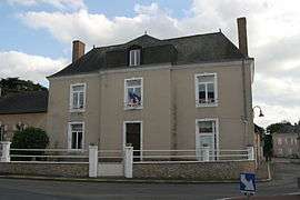
The school | |
 Le Breil-sur-Mérize | |
|
Location within Pays de la Loire region  Le Breil-sur-Mérize | |
| Coordinates: 48°00′27″N 0°28′38″E / 48.0075°N 0.4772°ECoordinates: 48°00′27″N 0°28′38″E / 48.0075°N 0.4772°E | |
| Country | France |
| Region | Pays de la Loire |
| Department | Sarthe |
| Arrondissement | Mamers |
| Canton | Montfort-le-Gesnois |
| Intercommunality | Communauté de communes du Pays des Brières et du Gesnois |
| Government | |
| • Mayor (2008–2014) | Jean-Paul Hubert |
| Area1 | 18.4 km2 (7.1 sq mi) |
| Population (2006[1])2 | 1,355 |
| • Density | 74/km2 (190/sq mi) |
| Time zone | CET (UTC+1) |
| • Summer (DST) | CEST (UTC+2) |
| INSEE/Postal code | 72046 / 72370 |
| Elevation | 86–157 m (282–515 ft) |
|
1 French Land Register data, which excludes lakes, ponds, glaciers > 1 km² (0.386 sq mi or 247 acres) and river estuaries. 2 Population without double counting: residents of multiple communes (e.g., students and military personnel) only counted once. | |
Le Breil-sur-Mérize is a commune in the Sarthe department in the region of Pays-de-la-Loire in north-western France.
See also
References
| Wikimedia Commons has media related to Le Breil-sur-Mérize. |
This article is issued from Wikipedia - version of the 7/11/2016. The text is available under the Creative Commons Attribution/Share Alike but additional terms may apply for the media files.