Gesnes-le-Gandelin
| Gesnes-le-Gandelin | ||
|---|---|---|
|
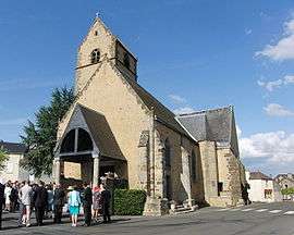
L'église Saint-Pierre | ||
| ||
 Gesnes-le-Gandelin | ||
|
Location within Pays de la Loire region  Gesnes-le-Gandelin | ||
| Coordinates: 48°21′00″N 0°01′00″E / 48.35°N 0.01670°ECoordinates: 48°21′00″N 0°01′00″E / 48.35°N 0.01670°E | ||
| Country | France | |
| Region | Pays de la Loire | |
| Department | Sarthe | |
| Arrondissement | Mamers | |
| Canton | Saint-Paterne | |
| Intercommunality | Communauté de communes des Portes du Maine Normand | |
| Government | ||
| • Mayor (2014–2020) | Michel Lajoinie | |
| Area1 | 12.88 km2 (4.97 sq mi) | |
| Population (2012)2 | 971 | |
| • Density | 75/km2 (200/sq mi) | |
| Time zone | CET (UTC+1) | |
| • Summer (DST) | CEST (UTC+2) | |
| INSEE/Postal code | 72141 / 72130 | |
| Elevation | 114–200 m (374–656 ft) | |
|
1 French Land Register data, which excludes lakes, ponds, glaciers > 1 km² (0.386 sq mi or 247 acres) and river estuaries. 2 Population without double counting: residents of multiple communes (e.g., students and military personnel) only counted once. | ||

Gesnes-le-Gandelin is a commune in the Sarthe department in the region of Pays-de-la-Loire in north-western France.
See also
References
| Wikimedia Commons has media related to Gesnes-le-Gandelin. |
This article is issued from Wikipedia - version of the 3/15/2016. The text is available under the Creative Commons Attribution/Share Alike but additional terms may apply for the media files.