Krumvíř
| Krumvíř | |||
| Village | |||
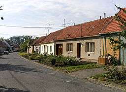 North part of Krumvíř village | |||
|
|||
| Country | Czech Republic | ||
|---|---|---|---|
| Region | South Moravian | ||
| District | Břeclav | ||
| Commune | Hustopeče | ||
| Municipality | Klobouky u Brna | ||
| Elevation | 184 m (604 ft) | ||
| Coordinates | CZ 48°59′14″N 16°54′41″E / 48.98722°N 16.91139°ECoordinates: CZ 48°59′14″N 16°54′41″E / 48.98722°N 16.91139°E | ||
| Area | 10.11 km2 (3.90 sq mi) | ||
| Population | 1,144 (2012) | ||
| Density | 113/km2 (293/sq mi) | ||
| Timezone | CET (UTC+1) | ||
| - summer (DST) | CEST (UTC+2) | ||
| Postal code | 691 73 | ||
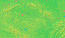  Location in the Czech Republic | |||
| Wikimedia Commons: Krumvíř | |||
| Website: www.krumvir.cz | |||

Krumvíř is a village in Břeclav District, South Moravian Region, Czech Republic. It has a population of 1,152 (2011). It lies in the traditional wine region.
External links
- (Czech) Official website
This article is issued from Wikipedia - version of the 6/12/2016. The text is available under the Creative Commons Attribution/Share Alike but additional terms may apply for the media files.