Dolní Dunajovice
| Dolní Dunajovice | |||
| Village | |||
|
|||
| Country | Czech Republic | ||
|---|---|---|---|
| Region | South Moravian | ||
| District | Břeclav | ||
| Elevation | 183 m (600 ft) | ||
| Coordinates | CZ 48°51′13″N 16°34′58″E / 48.85361°N 16.58278°ECoordinates: CZ 48°51′13″N 16°34′58″E / 48.85361°N 16.58278°E | ||
| Area | 17.87 km2 (7 sq mi) | ||
| - land | 15.64 km2 (6 sq mi) | ||
| - water | 2.23 km2 (1 sq mi) | ||
| Population | 1,693 (December 31, 2009[1]) | ||
| Density | 95/km2 (246/sq mi) | ||
| First Mentioned | 1183 | ||
| Mayor | Josef Hasník | ||
| Timezone | CET (UTC+1) | ||
| - summer (DST) | CEST (UTC+2) | ||
| Postal code | 691 85 | ||
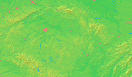  Location in the Czech Republic
| |||
| Statistics: www.statnisprava.cz, CZSO Public database | |||
| Website: http://www.dolni-dunajovice.cz/ | |||


Dolní Dunajovice (German: Unter-Tannowitz) is a village in Břeclav District of the South Moravian Region in the Czech Republic. It is located about 7 km (4.3 mi) northwest of Mikulov. The municipality has a population of 1,693 (2008).[1]
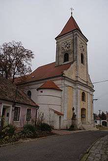
Church of St Giles
The settlement was first mentioned as Donavicz in an 1183 deed. In 1249 the Moravian margrave Přemysl Ottokar II granted it together with the Lordship of Mikulov to the Austrian noble Henry I of Liechtenstein.
Notable people
- Karl Renner (1870-1950), Austrian chancellor and president
External links
- (Czech) Official website
References
- 1 2 "Vybrané statistické údaje za obec" (in Czech). Czech Statistical Office. Retrieved August 3, 2009.
| Wikimedia Commons has media related to Dolní Dunajovice. |
This article is issued from Wikipedia - version of the 10/8/2016. The text is available under the Creative Commons Attribution/Share Alike but additional terms may apply for the media files.