Kebnekaise
- See Kebnekajse for the Swedish band.
| Kebnekaise | |
|---|---|
 Eastern slopes of Kebnekaise as seen from the Tarfala Valley | |
| Highest point | |
| Elevation | 2,099 m (6,886 ft) [1] |
| Prominence | 1,750 m (5,740 ft) [2] |
| Isolation | 757 kilometres (470 mi) |
| Listing |
Country high point Ultra |
| Coordinates | 67°54′00″N 18°31′00″E / 67.90000°N 18.51667°ECoordinates: 67°54′00″N 18°31′00″E / 67.90000°N 18.51667°E |
| Geography | |
 Kebnekaise | |
| Parent range | Scandinavian Mountains |
| Climbing | |
| First ascent | 1883 by Charles Rabot |
| Easiest route | rock/ice walk; most popular route includes simple scrambling |
Kebnekaise (Swedish pronunciation: [ˈkɛbnəˈkaisə];[3] from Sami Giebmegáisi or Giebnegáisi, "Cauldron Crest") is the highest mountain in Sweden. The Kebnekaise massif, which is part of the Scandinavian Mountains, has two peaks, of which the southern, glaciated one is highest at 2,097.5 metres (6,882 ft) above sea level as of August 2014. The northern peak is 2,096.8 metres (6,879 ft) and free of ice.[1] Kebnekaise lies in Sapmi, about 150 kilometres (ca. 90 miles) north of the Arctic Circle and west of Kiruna near the popular Kungsleden hiking trail between Abisko and Nikkaluokta.
The glacier which covers the southern peak has shrunk, and therefore the summit is not as high as earlier. The top is traditionally said to be 2,111 metres (6,926 ft), and higher in the oldest measurement, i.e. 2,117 metres (6,946 ft). If the melting continues at the same rate, the south peak will sink below the north peak (which is the highest fixed point in Sweden) within a few years' time.[4][5] However, as of July 2015, Tarfala Research Station reports that the glacier has grown by 4.5m to 2,102 - from its lowest measurement of 2097.5m the previous year.[6]
Routes
Kebnekaise mountain lodge (Kebnekaise fjällstation) is located at the foot of Kebnekaise, ca. 19 km, 6–7 hours from Nikkaluokta. It is the starting point for an ascent via the western route (västra leden, ca. 18 km, 5-7 hours to the summit) or the eastern route (östra leden, ca. 10 km, 3–5 hours to the summit). The western route leads over scree slopes and the intermediate peak Vierranvárri to the glaciated summit. Most of this route to the top is pure hiking, but there is a short exposed part that could possibly count as scrambling (YDS grade 2). The eastern route leads over glaciers and rocks and offers exposure (YDS grade 4). It is however equipped with fixed steel cables for protection, similar to a via ferrata.
There is also a third, more uncommon route only marked with cairns - "Durlings led", which branches off Kungsleden a few kilometers north of Singi, goes about two kilometers into the southern side of Singivagge, and then turns north into the valley between Kuopertjåkka and Singipakte (peak 1614). Some people, such as those with acrophobia or wanting to summit with heavy backpacks, may see benefits with this route as not a single point on it is exposed. "Durlings led" eventually merges with the western route close to the summit.
About 300 altitude meters below the top, one encounters the peak cabins. After the cabins, the trail continues through a rocky landscape and the slope progressively ceases. The peak glacier is a small top, merely tens of meters high, in a nearly flat landscape as seen from the trail.
To approach the actual mountain top on the peak glacier, crampons or other means of enhancing traction might at times be required. The glacier should be walked upon with great caution; fatal accidents have occurred with people sliding off into the huge void on the eastern side.[7] This danger might not always be apparent, especially not in times of bad weather and visibility.
Due to the harsh subarctic climate at the location, Kebnekaise sees the vast majority of climbers during the summer months (late June to early September). Even so, early in this season, snow can sometimes make a summit bid tedious. In Europe there are no higher mountains further north. During clear weather, a vast area can be seen from the summit, according to some sources as much as 10% of Sweden.[8]
Norwegian plane crash
On 15 March 2012 a Lockheed Martin C-130 Hercules military aircraft crashed into the western snowy mountain side a short distance below the ridge that runs between the mountain's two highest peaks. Five Norwegian officers were killed.
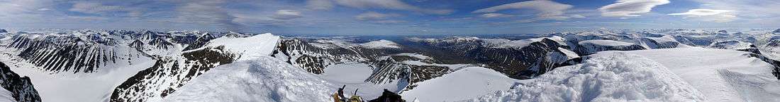
Panorama
See also
Gallery
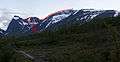 The western route marked with red dots.
 The oldest of the cabins close to the peak; standing at an 1880-meter altitude, built in 1924.[9]
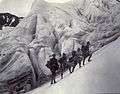 Mountaineers on Kebnekaise, early 20th century.
 The peak glacier seen from the trail, rising from a nearly flat plateau.
References
- 1 2 "Tarfala forskningsstation" (in Swedish). Stockholm University. Archived from the original on 21 October 2014. Retrieved 9 December 2014.
- ↑ "Mountains I have climbed and remember.". uib.no.
- ↑ "Word: Kebnekaise: Pronunciation in Swedish". Forvo: All the words of the world. Pronounced. Retrieved 29 January 2014.
- ↑ Malin Olofsson, "Toppskifte på Kebnekaise", Sveriges Radio, 15 June 2007, retrieved 27 March 2012 (Swedish)
- ↑ Kebnekaises sydtopp – högst i Sverige?, fjallklubben.org (broken link)
- ↑ Emil Östlund, "Sydtoppen växer på Kebnekaise", Sveriges Radio 23 July 2015, retrieved 27 October 2015 (Swedish)
- ↑ "Fjällvandrare föll 400 meter". Aftonbladet.
- ↑ "Reportage". swedenoffroad.com.
- ↑ "Toppstugorna > Boende > Kebnekaise". kebnekaise.nu.
External links
| Wikimedia Commons has media related to Kebnekaise. |
- Find out adventurous activities to be done at Kebnekaise Mountain
- Photo gallery on Marco Klüber Photography
- Ski touring reports from Swedish mountains, including Kebnekaise (English)