Beerenberg
| Beerenberg | |
|---|---|
 Beerenberg, July 2011 | |
| Highest point | |
| Elevation | 2,277 m (7,470 ft) |
| Prominence | 2,277 m (7,470 ft) |
| Listing | Ultra |
| Coordinates | 71°4′36″N 8°9′52″W / 71.07667°N 8.16444°WCoordinates: 71°4′36″N 8°9′52″W / 71.07667°N 8.16444°W |
| Geography | |
| Geology | |
| Mountain type | Stratovolcano |
| Last eruption | January 1985 |
| Climbing | |
| First ascent | 1921 Wordie, Mercanton and Lethbridge[1] |
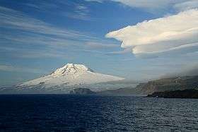
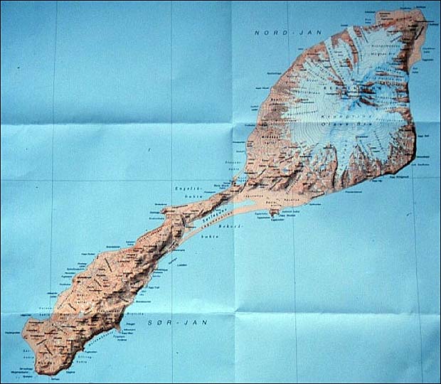
Beerenberg is a 2,277 m (7,470 ft) stratovolcano which forms the northeastern end of the Norwegian island of Jan Mayen.[2] It is the world's northernmost subaerial active volcano.[3] The volcano is topped by a mostly ice-filled crater about 1 km (0.6 mi) wide,[4] with numerous peaks along its rim including the highest summit, Haakon VII Toppen, on its western side.
The upper slopes of the volcano are largely ice-covered, with several major glaciers including five which reach the sea.[5] The longest of the glaciers is the Weyprecht Glacier, which flows from the summit crater via a breach through the northwestern portion of the crater rim, and extends about 6 km (4 mi) down to the sea.
Beerenberg is composed primarily of basaltic lava flows with minor amounts of tephra. Numerous cinder cones have been formed along flank fissures.
Its most recent eruptions took place in 1985 and 1970[6] both of which were flank eruptions from fissures on the northeast side of the mountain. Other eruptions with historical records occurred in 1732, 1818, and 1851.[4]
Its name means "Bear Mountain" in Dutch, and it takes its name from the polar bears seen there by Dutch whalers in the early 17th century.[7]
See also
References
- ↑ Chetwode, Philip; et al. (1939). "The Imperial College Expedition to Jan Mayen Island: Discussion". The Geographical Journal. 94 (2): 131–134. doi:10.2307/1787248. JSTOR 1787248.
- ↑ "Jan Mayen: volcano in the freezer". Volcanocafe.org. 25 Aug 2015. Retrieved 31 May 2016.
- ↑ "Jan Mayen Expedition 1997 European Volcanological Society". Retrieved 4 May 2015.
- 1 2 "Jan Mayen". Global Volcanism Program. Smithsonian Institution.
- ↑ Jan Mayen Topographic Map
- ↑ Sylvester, Arthur Gibbs. "Seismic Search for Magma Chambers Beneath Jan Mayen and Field Inspection of the 1970 Beerenberg Eruption Area". University of California. Retrieved 31 May 2016.
- ↑ James Gordon Hayes, The Conquest of the North Pole: Recent Arctic Exploration, p. 222, Taylor & Francis, 1934
External links
| Wikimedia Commons has media related to Beerenberg. |
- Jan Mayen Homepage, including general info, photos, blog, and webcam
- Beerenberg Expedition 2008 Pictures
- Pictures and a map of Beerenberg
- 1970 Beerenberg volcanic eruption captured on film