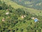
Karaputar
| Karaputar करापुटार नगरपालिका | |
|---|---|
| Municipality | |
 | |
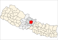
 Karaputar Location in Nepal | |
| Coordinates: 28°12′N 84°14′E / 28.20°N 84.24°ECoordinates: 28°12′N 84°14′E / 28.20°N 84.24°E | |
| Country |
|
| Zone | Gandaki |
| District | Lamjung District |
| Population (2011) | |
| • Total | 10,836 |
| Time zone | NST (UTC+5:45) |
| Area code(s) | 066 |
.jpg)
Karaputar[1] is a municipality of Lamjung District in Gandaki Zone of central Nepal. The municipality was established on 19 September 2015 by merging the existing Bangre, Bhorletar, Isaneshwor and Karapu village development committees (VDCs).[2][3] The center of the municipality is establish in former VDC Office of Karapu Bazaar. After merging the four VDCs population it had a total population of 10,836 according to 2011 Nepal census.[4] After the government decision the number of municipalities has reached 217 in Nepal.[5]
Municipality
The Government announced additional 26 municipalities. With this announcement Karaputar has been upgraded as one of the municipalities of Nepal, previously it was proposed municipality. Adjoining Bangre, Bhorletar, Isaneshwor and Karapu VDC was merged with Karaputar to upgrade it to the municipality.
References
- ↑ "Govt declares 26 new municipalities". EKantipur. 19 September 2015.
- ↑ "26 new Municipalities announced". The Rising Nepal. Retrieved 2015-09-18.
- ↑ "Govt announces 26 municipalities" (PDF). The Kathmandu Post. Retrieved 2015-09-18.
- ↑ Central Bureau of Statistics of Nepal: National Population and Housing Census 2011
- ↑ "Govt adds 26 municipalities, 1 sub metropolis". Setopati. Retrieved 18 September 2015.