Duradanda
| Duradanda दुराडाँडा | |
|---|---|
| Village development committee | |
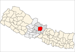
 Duradanda Location in Nepal | |
| Coordinates: 28°10′N 84°22′E / 28.16°N 84.37°ECoordinates: 28°10′N 84°22′E / 28.16°N 84.37°E | |
| Country |
|
| Zone | Gandaki Zone |
| District | Lamjung District |
| Population (1991) | |
| • Total | 2,135 |
| Time zone | Nepal Time (UTC+5:45) |
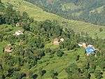
Duradanda is a village development committee in Lamjung District in the Gandaki Zone of northern-central Nepal. At the time of the 1991 Nepal census Facing east, it lies between river Kirenche in the east and Paudi river in the south, Chadreswar Village in west .There is only high school named Sanskriti Sadan at village Archalyani .Duradanda had a population of 2135 people living in 430 individual households. It is three hour walk form the Sundarbazar. There are nine ward in Duradanda VDC and among them Puranadehi known as Tiwari Gaun is the most prominent village for the literacy level, political revolution and increasing population rate of Dura.[1]
References
- ↑ "Nepal Census 2001", Nepal's Village Development Committees, Digital Himalaya, retrieved 15 November 2009.
External links
This article is issued from Wikipedia - version of the 5/7/2016. The text is available under the Creative Commons Attribution/Share Alike but additional terms may apply for the media files.