Archalbot
| Archalbot अर्चलबोट | |
|---|---|
| Village development committee | |
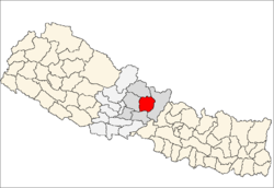
 Archalbot Location in Nepal | |
| Coordinates: 28°14′4″N 83°58′59″E / 28.23444°N 83.98306°ECoordinates: 28°14′4″N 83°58′59″E / 28.23444°N 83.98306°E | |
| Country |
|
| Zone | Gandaki Zone |
| District | Lamjung District |
| Population (2011) | |
| • Total | 4,765 |
| Time zone | Nepal Time (UTC+5:45) |
| Area code(s) | 066 |
Archalbot is a village development committee in Lamjung District in the Gandaki Zone of northern-central Nepal. At the time of the 1991 Nepal census it had a population of 1650 people living in 333 individual households.[1]
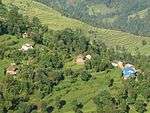
The paddy fields for rice farming and the terraces are a characteristic of the village area. Nearby is the Tamang community of Phurano Dobar, which was recently installed with a clean water system. Surrounding the VDC are rhododendron forests, which give view to the Himalayan peaks from the Annapurnas in the west to Manaslu to the Langtang area in the east.[2]
References
- ↑ "Nepal Census 2001". Nepal's Village Development Committees. Digital Himalaya. Archived from the original on 12 October 2008. Retrieved 15 November 2009..
- ↑ "Manaslu Trek". Skyline Treks and Expedition.
External links
This article is issued from Wikipedia - version of the 10/17/2016. The text is available under the Creative Commons Attribution/Share Alike but additional terms may apply for the media files.