Irwin, Missouri
| Irwin, Missouri | |
|---|---|
| Census-designated place & unincorporated community | |
 Irwin Location of Irwin, Missouri | |
| Coordinates: 37°35′19″N 94°17′08″W / 37.58861°N 94.28556°WCoordinates: 37°35′19″N 94°17′08″W / 37.58861°N 94.28556°W | |
| Country | United States |
| State | Missouri |
| Counties | Barton |
| Area | |
| • Total | 0.30 sq mi (0.78 km2) |
| • Land | 0.29 sq mi (0.76 km2) |
| • Water | 0.008 sq mi (0.02 km2) |
| Elevation | 974 ft (297 m) |
| Population (2010) | |
| • Total | 69 |
| • Density | 233/sq mi (89.9/km2) |
| Time zone | Central (CST) (UTC-6) |
| • Summer (DST) | CDT (UTC-5) |
| ZIP code | 64759 |
| Area code(s) | 417 |
| FIPS code | 29-35486[1] |
| GNIS feature ID | 0720173[2] |
Irwin is an unincorporated community and census-designated place in northern Barton County, Missouri, United States. As of the 2010 census it had a population of 69.[3]
History
Irwin was platted in 1884.[4] The community has the name of the Irwin family of settlers.[5] A post office called Irwin was established in 1884, and remained in operation until 1981.[6]
Geography
Irwin is located at 37°35′19″N 94°17′7″W / 37.58861°N 94.28528°W,[7] halfway between Lamar and Sheldon on U.S. Route 71 (Interstate 49). Mail is from Lamar.
According to the United States Census Bureau, the CDP has a total area of 0.30 square miles (0.78 km2), of which 0.0077 square miles (0.02 km2), or 2.00%, is water.[3]
References
- ↑ "American FactFinder". United States Census Bureau. Retrieved 2008-01-31.
- ↑ "US Board on Geographic Names". United States Geological Survey. 2007-10-25. Retrieved 2008-01-31.
- 1 2 "Geographic Identifiers: 2010 Demographic Profile Data (G001): Irwin CDP, Missouri". U.S. Census Bureau, American Factfinder. Retrieved January 23, 2014.
- ↑ Eaton, David Wolfe (1916). How Missouri Counties, Towns and Streams Were Named. The State Historical Society of Missouri. p. 207.
- ↑ "Barton County Place Names, 1928-1945 (archived)". The State Historical Society of Missouri. Retrieved 31 August 2016.
- ↑ "Post Offices". Jim Forte Postal History. Retrieved 27 August 2016.
- ↑ "US Gazetteer files: 2010, 2000, and 1990". United States Census Bureau. 2011-02-12. Retrieved 2011-04-23.
Municipalities and communities of Barton County, Missouri, United States | ||
|---|---|---|
| Cities | 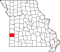 | |
| Villages | ||
| Townships | ||
| CDP | ||
| Other unincorporated communities | ||
| Ghost towns | ||
This article is issued from Wikipedia - version of the 10/25/2016. The text is available under the Creative Commons Attribution/Share Alike but additional terms may apply for the media files.