Imnajbu
| Imnajbu | |
|---|---|
| Barangay | |
 | |
| Coordinates: 20°23′14″N 121°57′40″E / 20.38722°N 121.96111°ECoordinates: 20°23′14″N 121°57′40″E / 20.38722°N 121.96111°E | |
| Country: |
|
| Region: | Cagayan Valley |
| Province: | Batanes |
| Municipality: | Uyugan |
| Congressional District | Lone District of Batanes |
| Date Established | May 20, 1909 |
| Government | |
| • Type | Barangay Council (2010-2013) |
| • Brgy. Chairman | Exequiel V. Valiente |
| • Brgy. Councilors |
List
|
| • SK Chairman | Jomar C. Anay |
| Area | |
| • Land | 5.1 km2 (2.0 sq mi) |
| Population (2010) | |
| • Total | 159 |
| • Density | 27.3/km2 (71/sq mi) |
| Time zone | PHT (UTC+8) |
| Postal Code | 3903 |
| Area code(s) | 78 |
| PSGC | 020906002 |
Imnajbu is one of the four barangays (political subdivisions) that comprise the municipality of Uyugan in the province of Batanes, Philippines. It is also one of the smallest barangays in all of Batanes and in the Philippines with a population of around a couple of hundred people. Located in the southeast corner of Batan Island (mainland Batanes), it is bounded by Itbud to the southeast, Uyugan to the southwest, Ivana and Mount Matarem to the west, Mahatao to the north, and the Philippine Sea/Pacific Ocean to the east.
Geography
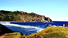
Imnajbu is rugged country. A range of rocky hills stretches from Itbud to the south and Mahatao to the north. This mountain range cuts the territory or barangay/district in half. West of this range are the low-lying hills, and to the east are the foothills and rugged coastlines. Nestled in the foothills is the village settlement or the "Borough of Imnajbu" as Imnajbians call it. In Ivatan (the local language), "Imnajbu" means the resettlement to the lowland or downhill, and it goes back to Spanish colonization. It is seven kilometres from the town proper of Uyugan and twenty-five kilometres from Basco (the provincial capital) through the main coastal highway (Mahatao-Ivana-Uyugan) but fifteen kilometres away through the Interior Road (Mahatao-Imnajbu).
The climate ranges from humid oceanic to sub-tropic. The Philippine Sea/Pacific Ocean to the east moderate the climate -- cooling summers. It's coldest in February and warmest in May. February temperatures average 20 degrees Celsius. May average temperatures range from 30 degrees Celsius to 35 degrees Celsius. The average (mean) annual air temperature is less than 10 degrees Celsius in February, but it's much more changeable in the northwest (foothills of Mount Matarem).
Precipitation is heaviest during the non-summer months brought in by the typhoons that frequent the area. Imnajbu's annual rainful varies, but is highest in the northwest and lowest in the southeast. The heaviest rainfuls happen in a belt lying inland from Mount Vatuhayao in the central highlands to Mount Mayvatek in the north central region.
The weather is foggy at the onset of the colder months, caused by the cold front or polar air from the north (Continental Asia/Siberia) meeting warm moist air from the south.
History
Thousands of years before Spanish colonization, about a hundred people lived on a fortified cliff and hilltop a kilometre uphill from present day Imnajbu. The fortified settlement was called "Idiang" and derived from the Ivatan word "Idi" or "Idian" which meant home or hometown. They belonged to the Ivatan tribes and spoke the same Ivatan language but with a southern accent. Today the locals call the old settlement 'Nakavahayan' which is now partly cut in half by the Interior Road (next to Chinteb Pass)!
The Ivatan tribe who called the place home farmed, where soil permitted, and fished. They were also a boat-making and seafaring people and they trade with neighbouring tribes and with Taiwan to the North and Cagayan to the South.
The Nakavahayan settlement was like any other Ivatan tribal settlement that had a de facto tribal government, not very much different from that of tribal governments in the earlier stages of human evolution. The tribal settlement was headed by a chieftain with a deputy. Inter-tribal hostilities (Arap du Tukon) were common in those days but for men only. Common law prohibited the harming of womenfolk who were the main providers of food in wartime.
Imnajbu - The Birthplace of Christianity in Batanes

According to church records, the first mass and baptism in the islands was celebrated in what is now Imnajbu. Fr. Mateo Gonzales, OP, Apostle of Batanes, first landed in Imnajbu in 1682 A.D. when he came to survey the prospects of evangelization in the Batanes Archipelago. It was in the village of Imnajbu where the first holy mass on Ivatan soil was celebrated and the first baptism administered, making Imnajbu the birthplace of Christianity in Batanes. Today, Imnajbu is a barangay of the municipality of Uyugan, its patron saint is the first canonized Filipino saint, San Lorenzo Ruiz de Manila.
Little America on Ivatan soil
.jpg)
The Americans followed the Spaniards to Batanes after the Spanish naval defeat at Manila Bay in 1898. The USS Princeton (PG-13) that joined the Asiatic Fleet in April 1899 took formal possession of Batanes in January 1900. American public school system was introduced and general health and sanitation campaign was launched. In the 1930s, the Americans built a better road system that replaced the road system (El Camino Real) built during the Spanish period.

In the early 1950s a USCG LORAN Station was built a kilometre south of Imnajbutown in Payapay Commons next to Madangay Falls (water flow altered and water falls during the rainy season was destroyed by the Interior Road) and near Imnajbu Point (Alapad Pass and the famed Dead Man's Curve). The Americans left in the early 1970s as satellite communications made the Loran System redundant, but during the 2 decades of American occupation, it was a place unlike any place in Batanes at the time. It was the near equivalent of "middle class" America on Ivatan soil, and it was known as "Little America" to the locals.
Demographics
The population has not changed much since its founding as a barangay. Its population was 159 in 2010. This is around a tenth of Uyugan's and a per cent of Batanes' population. All the people, except one or two, speak Ivatan as their first language, while most of the people speak Tagalog or Filipino and English (or the mix called Taglish) as their second language. The barangay or municipal district has a main street and a public square as the core of the people's socio-economic life.
Economy
The Imnajbu economy is mainly agriculture, fishing and services (structural change from goods-producing to service-producing).
- Agriculture
- Farming in Imnajbu began long before the arrival of the Spaniards. The Imnajbians loved the land and cultivated many plants for food. Imnajbian farmers started with root crops, but when the Spaniards arrived, they learned to grow other crops, while introducing livestock and vegetables. Farming meant growing root crops -- often just enough to feed the farmer's family. Camoté and other root crops became Imnajbu's most hardy and widely grown crops, but in the 1950s, livestock became more important than root crops on Imnajbu farms. The government brought breeding bulls and the farmers moved to "mixed" farming on a small scale. Imnajbu's farms are not scientific, but government agricultural extension workers give direction and support to farming methods. The farmers seldom have problems like plant and animal diseases and pests. Today's Imnajbian farmer still could barely feed his family due to antiquated methods of farming dictated mainly by the topography of the land that at best is unsuitable to agriculture. Nevertheless, Imnajbu was a leading producer of beef cattle and garlic prior to the global economy. Camoté is now mainly produced as feed for the hog industry.
- Fishing
- Fishing continues to play an important role in partly meeting the fish requirements of the community. The prevailing fishing methods are hook and line and cast nets but slowly advancing to more modern fishing methods. Situated near Imnajbu is Madi Bay in Mahatao and one of the richest fishing grounds in all of mainland Batanes, where Imnajbians along with other Ivatans engaged in coastal fishing.
- Service Sector
- Services account for most of the paid employment in Imnajbu, and more significantly, most jobs creation were in the service sector, but it still comprise a tiny share of the economic output. The most important service industry is government or public administration. It plays a vital role in the local economy.
External links
| Wikimedia Commons has media related to Imnajbu, Batanes. |
- Imnajbu, Batanes website
- Barangay Officials of Batanes
- Senator Legarda: EarthLink Batanes
- SEAIR and the Fields and Hills of Mainland Batanes
- The Philippines moves forward