Igrejinha
| Município de Igrejinha | |||
|---|---|---|---|
|
| |||
| |||
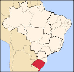
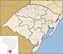 Location in Rio Grande do Sul, Brazil | |||
| Coordinates: 29°34′26″S 50°47′24″W / 29.57389°S 50.79000°WCoordinates: 29°34′26″S 50°47′24″W / 29.57389°S 50.79000°W | |||
| Country | Brazil | ||
| Region | South | ||
| State | Rio Grande do Sul | ||
| Emanciped | 1964-06-01 | ||
| Government | |||
| • Mayor | Elir Domingo Girardi (PTB) | ||
| Area[1] | |||
| • Total | 136.816 km2 (52.825 sq mi) | ||
| Elevation | 18 m (59 ft) | ||
| Population (2006 est.)[1] | |||
| • Total | 31,389 | ||
| • Density | 229.4/km2 (594/sq mi) | ||
| Time zone | UTC-3 (UTC-3) | ||
| • Summer (DST) | UTC-2 (UTC-2) | ||
| Website | igrejinha.rs.gov.br | ||


Igrejinha is a municipality located in the Serra Gaúcha of Rio Grande do Sul, Brazil. The city has approximately 31,000 inhabitants and sits about 82 km (about 51 miles) from the capital city of the state, Porto Alegre.
Oktoberfest

Igrejinha Oktoberfest 2007
Each year, the citizens of Igrejinha and visitors from the region celebrate Oktoberfest. The city has a large population of German-Brazilians. Thousands turn out each year for the Oktoberfest celebration.
The most significant period for tourism is during Oktoberfest, a traditional Bavarian beer festival, which sold 186,000 tickets at its pavilions in 2005—at which 209,561 liters of beer were drunk.
Town partnership
External links
- (Portuguese) Igrejinha Hall website
- Igrejinha Oktoberfest site functions a few months before October only
More photos of Igrejinha
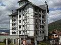 Building
 Oktoberfest
 Route RS 115
 Oktoberfest
References
- 1 2 (Portuguese) Cidades@, Brazilian Institute of Geography and Statistics, Accessed on 2007-09-25.
- ↑ http://www.simmern.de/de/stadtsimmern_partnerschaften_Partnerstadt_Igrejinha.html?q=Igrejinha
This article is issued from Wikipedia - version of the 5/22/2016. The text is available under the Creative Commons Attribution/Share Alike but additional terms may apply for the media files.