Arroio do Padre
| Arroio do Padre | |
|---|---|
 | |
 Location in Rio Grande do Sul, Brazil | |
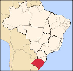
 Arroio do Padre Location in Brazil | |
| Coordinates: 31°26′34″S 52°25′19″W / 31.44278°S 52.42194°WCoordinates: 31°26′34″S 52°25′19″W / 31.44278°S 52.42194°W | |
| Country | Brazil |
| Region | South |
| State | Rio Grande do Sul |
| Founded | 1996 |
| 1996 (city) | |
| Government | |
| • Mayor | Jaime Starke (PP) |
| Area | |
| • Total | 124.321 km2 (48.001 sq mi) |
| Elevation | 290 m (950 ft) |
| Population (2009 est.) | |
| • Total | 2,882 |
| • Density | 22.03/km2 (57.1/sq mi) |
| Time zone | UTC-3 (UTC-3) |
| • Summer (DST) | UTC-2 (UTC-2) |
| Website | Prefeitura de Arroio do Padre |
Arroio do Padre (Portuguese pronunciation: [aˈʁoju du ˈpadɾi], Portuguese meaning Priest's Stream) is a Brazilian municipality in the southeastern part of the state of Rio Grande do Sul. Its 2009 population was 2,882.
Much of the population have Pomeranian origin and are Evangelical Lutheran.
External links
This article is issued from Wikipedia - version of the 5/15/2016. The text is available under the Creative Commons Attribution/Share Alike but additional terms may apply for the media files.