Eugênio de Castro
For the Portuguese writer, see Eugénio de Castro.
| Eugênio de Castro | |
|---|---|
| Municipality | |
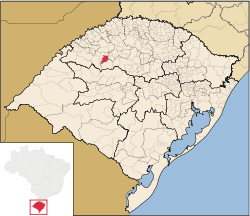 Location in Rio Grande do Sul state | |
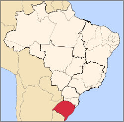
 Eugênio de Castro Location in Brazil | |
| Coordinates: 28°21′30″S 54°8′56″W / 28.35833°S 54.14889°WCoordinates: 28°21′30″S 54°8′56″W / 28.35833°S 54.14889°W | |
| Country |
|
| State | Rio Grande do Sul |
| Micro-region | Santo Ângelo |
| Area | |
| • Total | 419.32 km2 (161.90 sq mi) |
| Population (2015) | |
| • Total | 2,744 |
| • Density | 6.5/km2 (17/sq mi) |
| Time zone | BRT (UTC-3) |
| • Summer (DST) | BRST (UTC-2) |
| Website |
www |
Eugênio de Castro is a municipality of the northern part of the state of Rio Grande do Sul, Brazil. The population is 2,744 (2015 est.) in an area of 419.32 km².[1] It is located 435 km west of the state capital of Porto Alegre, northeast of Alegrete.
Bounding municipalities
References
External links
- http://www.citybrazil.com.br/rs/eugeniodecastro/ (Portuguese)
This article is issued from Wikipedia - version of the 5/15/2016. The text is available under the Creative Commons Attribution/Share Alike but additional terms may apply for the media files.