Homolje mountains
| Homolje mountains | |
|---|---|
 | |
| Highest point | |
| Elevation | 940 m (3,080 ft) [1] |
| Coordinates | 44°21′31″N 21°37′45″E / 44.35861°N 21.62917°ECoordinates: 44°21′31″N 21°37′45″E / 44.35861°N 21.62917°E |
| Geography | |
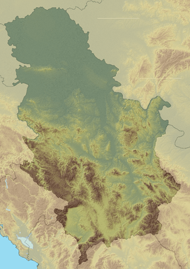 Homolje mountains Location in Serbia | |
| Location | Eastern Serbia |
| Parent range | Serbian Carpathians |
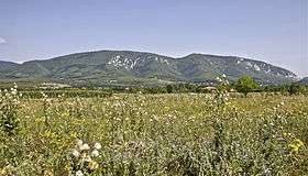
Homolje mountains (Serbian: Хомољске планине, Homoljske planine) is a mountain range in eastern Serbia. The region they are in is also known as Homolje and located between towns of Žagubica in the south and Kučevo in the north.
Their highest peaks are Štubej (940 m) and Vranj (884 m). Hidden in the mountains is the Orthodox monastery of Vitovnica.[2]
The region of Homolje is sparsely populated, with ethnic Vlachs of Serbia making a majority of residents in some areas thereof, and because of the small population its nature is unspoilt. One of its attractions is a vast forest called Trest.
References
- ↑ Jovan Đokić. "Katalog planina Srbije". PSD Kopaonik Beograd.
- ↑ Manastir Vitovnica (in Serbian)
External links
This article is issued from Wikipedia - version of the 7/21/2015. The text is available under the Creative Commons Attribution/Share Alike but additional terms may apply for the media files.