Homestead, New Mexico
| Homestead, New Mexico | |
|---|---|
| Census-designated place | |
 Homestead | |
| Coordinates: 34°08′56″N 107°52′55″W / 34.14889°N 107.88194°WCoordinates: 34°08′56″N 107°52′55″W / 34.14889°N 107.88194°W | |
| Country | United States |
| State | New Mexico |
| County | Catron |
| Area[1] | |
| • Total | 1.172 sq mi (3.04 km2) |
| • Land | 1.171 sq mi (3.03 km2) |
| • Water | 0.001 sq mi (0.003 km2) |
| Elevation | 7,664 ft (2,336 m) |
| Population (2010)[1] | |
| • Total | 47 |
| • Density | 40/sq mi (15/km2) |
| Time zone | Mountain (MST) (UTC-7) |
| • Summer (DST) | MDT (UTC-6) |
| Area code(s) | 575 |
| GNIS feature ID | 2584113[2] |
Homestead is a census-designated place in Catron County, New Mexico, United States. Its population was 47 as of the 2010 census.[1]
Geography
Homestead is located at 34°08′43″N 107°52′40″W / 34.145226°N 107.877703°W. According to the U.S. Census Bureau, the community has an area of 1.172 square miles (3.04 km2); 1.171 square miles (3.03 km2) of its area is land, and 0.001 square miles (0.0026 km2) of it is water.[1]
References
Municipalities and communities of Catron County, New Mexico, United States | ||
|---|---|---|
| Village | 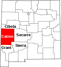 | |
| CDPs | ||
| Other unincorporated communities | ||
| Ghost towns |
| |
This article is issued from Wikipedia - version of the 10/16/2014. The text is available under the Creative Commons Attribution/Share Alike but additional terms may apply for the media files.