Aragon, New Mexico
| Aragon, New Mexico | |
|---|---|
| Census-designated place | |
 Aragon Location within the state of New Mexico | |
| Coordinates: 33°52′48″N 108°32′24″W / 33.88000°N 108.54000°WCoordinates: 33°52′48″N 108°32′24″W / 33.88000°N 108.54000°W[1] | |
| Country | United States |
| State | New Mexico |
| County | Catron |
| Area | |
| • Total | 8.5 sq mi (21.9 km2) |
| • Land | 8.5 sq mi (21.9 km2) |
| • Water | 0 sq mi (0 km2) |
| Population (2010) | |
| • Total | 94 |
| • Density | 11/sq mi (4.3/km2) |
| Time zone | Mountain (MST) (UTC-5) |
| • Summer (DST) | MDT (UTC) |
| ZIP code | 87820[2] |
| Area code(s) | 575 |
Aragon is an unincorporated community and census-designated place on the Tularosa River in Catron County, New Mexico, United States. As of the 2010 census it had a population of 94.[3] It is located at an altitude of 7,135 feet (2,175 m), 7 miles (11 km) northeast of Apache Creek.
The latitude is 33.88 N, longitude 108.54 W.
History
Fort Tularosa
Aragon is on the site of former Fort Tularosa 33°52′52″N 108°32′18″W / 33.88111°N 108.53833°W, which was built in 1872 to protect the Apache Indian Agency from the Ojo Caliente Band of Apaches. The fort was abandoned when the tribe was moved back to the Ojo Caliente reservation in 1874. A stockade was built on the site of the earlier fort in 1880 by Buffalo Soldiers led by Sergeant George Jordan. Jordan eventually received the Medal of Honor for leading 25 men to repulse a force of more than 100 Indians in the Battle of Fort Tularosa.
The only remaining evidence of the fort is a burial ground for soldiers who served in the Arizona Territory.[4] ,[5]
The town
The town was known as "Joseph" from 1887 to 1898 and 1901 to 1906. Since 1906 it has been known as "Aragon", named for an old Spanish family who still lives in the area. Near Aragon, on the north side of Tularosa Canyon, a cave was occupied from 400 B.C. to A.D. 1100, containing pits and later masonry rooms.[6]
-

River
-
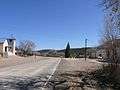
Road
-
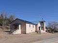
Santo Niño church
References
- ↑ U.S. Geological Survey Geographic Names Information System: Aragon, New Mexico
- ↑ "87820 Map". Retrieved 2016-08-03.
- ↑ "Geographic Identifiers: 2010 Demographic Profile Data (G001): Aragon CDP, New Mexico". U.S. Census Bureau, American Factfinder. Retrieved October 16, 2014.
- ↑ Catron County New Mexico: Aragon Cemetery. Archived September 8, 2008, at the Wayback Machine.
- ↑ Billington,Monroe Lee,Univ.Press of CO,1991, New Mexico's Buffalo Soldiers
- ↑ Banks, P.H. (nd) Cruzville, Apache Creek, Aragon and Old Horse Springs — NM Hwy12 from Reserve to Datil Archived June 8, 2007, at the Wayback Machine.. SouthernNewMexico.com. Retrieved 6/13/07.
External links
- Fort Tularosa from the New Mexico Office of the State Historian.
| Wikimedia Commons has media related to Aragon, New Mexico. |
Municipalities and communities of Catron County, New Mexico, United States | ||
|---|---|---|
| Village | 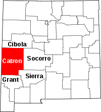 | |
| CDPs | ||
| Other unincorporated communities | ||
| Ghost towns |
| |