Hatfield, Pennsylvania
| Borough of Hatfield | |
| Borough | |
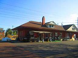 Former Reading station | |
| Country | United States |
|---|---|
| State | Pennsylvania |
| County | Montgomery |
| Elevation | 335 ft (102.1 m) |
| Coordinates | 40°16′41″N 75°17′56″W / 40.27806°N 75.29889°WCoordinates: 40°16′41″N 75°17′56″W / 40.27806°N 75.29889°W |
| Area | 0.6 sq mi (1.6 km2) |
| - land | 0.6 sq mi (2 km2) |
| - water | 0.0 sq mi (0 km2), 0% |
| Population | 3,290 (2010) |
| Density | 4,102.7/sq mi (1,584.1/km2) |
| Government | Council-manager |
| Mayor | Robert L. Kaler |
| Timezone | EST (UTC-5) |
| - summer (DST) | EDT (UTC-4) |
| ZIP Code | 19440 |
| Area code | 215 and 267 |
 Location of Hatfield in Montgomery County | |
 Location of Hatfield in Pennsylvania | |
 Location of Pennsylvania in the United States | |
| Website: http://www.hatfieldborough.com | |
Hatfield is a borough in Montgomery County, Pennsylvania, United States. The population was 3,290 at the time of the 2010 census. It is part of the North Penn Valley region that is centered around the borough of Lansdale.
Geography
According to the United States Census Bureau, the borough has a total area of 0.6 square miles (1.6 km2), all of it land.
Demographics
| Historical population | |||
|---|---|---|---|
| Census | Pop. | %± | |
| 1900 | 528 | — | |
| 1910 | 705 | 33.5% | |
| 1920 | 830 | 17.7% | |
| 1930 | 1,149 | 38.4% | |
| 1940 | 1,301 | 13.2% | |
| 1950 | 1,624 | 24.8% | |
| 1960 | 1,941 | 19.5% | |
| 1970 | 2,385 | 22.9% | |
| 1980 | 2,533 | 6.2% | |
| 1990 | 2,650 | 4.6% | |
| 2000 | 2,605 | −1.7% | |
| 2010 | 3,290 | 26.3% | |
| Est. 2015 | 3,306 | [1] | 0.5% |
| Sources:[2][3][4] | |||
As of the 2010 census, the borough was 66.6% White, 4.1% Black or African American, 0.1% Native American, 23.5% Asian, and 2.9% were two or more races. 6.8% of the population were of Hispanic or Latino ancestry [5]
As of the census[3] of 2000, there were 2,605 people, 1,106 households, and 650 families residing in the borough. The population density was 4,102.7 people per square mile (1,596.5/km2). There were 1,139 housing units at an average density of 1,793.9 per square mile (698.0/km2). The racial makeup of the borough was 82.19% White, 1.77% African American, 0.31% Native American, 12.05% Asian, 0.04% Pacific Islander, 1.42% from other races, and 2.23% from two or more races. Hispanic or Latino of any race were 3.34% of the population.
There were 1,106 households, out of which 30.5% had children under the age of 18 living with them, 46.5% were married couples living together, 8.8% had a female householder with no husband present, and 41.2% were non-families. 35.0% of all households were made up of individuals, and 7.8% had someone living alone who was 65 years of age or older. The average household size was 2.31 and the average family size was 3.03.
In the borough the population was spread out, with 23.2% under the age of 18, 8.2% from 18 to 24, 37.1% from 25 to 44, 19.9% from 45 to 64, and 11.7% who were 65 years of age or older. The median age was 35 years. For every 100 females there were 95.6 males. For every 100 females age 18 and over, there were 92.0 males.
The median income for a household in the borough was $45,975, and the median income for a family was $52,743. Males had a median income of $38,939 versus $30,775 for females. The per capita income for the borough was $21,133. About 4.2% of families and 5.5% of the population were below the poverty line, including 6.5% of those under age 18 and 8.1% of those age 65 or over.
Politics and government
Hatfield has a city manager form of government with a mayor and a five-member borough council. The mayor is Robert L. Kaler.
The borough is part of the United States House of Representatives Pennsylvania District 8 (represented by Rep. Mike Fitzpatrick).[6] Pennsylvania's 53rd Representative District (represented by Rep. Robert Godshall) and the 12th State Senate District (represented by Sen. Stewart Greenleaf).
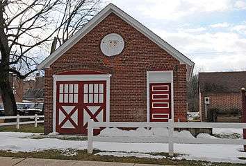 Former Electrical Substation, Jailhouse & Firehouse
 NPWA Pumphouse
| Year | Republican | Democratic |
|---|---|---|
| 2012 | 39.4% 500 | 58.6% 743 |
| 2008 | 37.7% 493 | 60.6% 793 |
| 2004 | 47.7% 595 | 51.6% 643 |
| 2000 | 51.8% 439 | 43.8% 371 |
Notable people
- Jim Molinaro, professional football player, Dallas Cowboys.
- Brandon McManus, professional football player, Denver Broncos.
Transportation
Historically, a rail line which was formally Reading Company's Bethlehem Branch runs north-south through Hatfield connecting to Souderton, Perkasie, Quakertown, and Bethlehem to the north and Lansdale to the south. The line was used by the SEPTA Bethlehem Line until 1981. The tracks are still used for the transport of freight between Lansdale and Quakertown, and beyond. The line is used for occasional scenic rail trips, and resumption of passenger service to Quakertown is being considered.
References
- ↑ "Annual Estimates of the Resident Population for Incorporated Places: April 1, 2010 to July 1, 2015". Retrieved July 2, 2016.
- ↑ "Census of Population and Housing". U.S. Census Bureau. Retrieved 11 December 2013.
- 1 2 "American FactFinder". United States Census Bureau. Retrieved 2008-01-31.
- ↑ "Incorporated Places and Minor Civil Divisions Datasets: Subcounty Resident Population Estimates: April 1, 2010 to July 1, 2012". Population Estimates. U.S. Census Bureau. Retrieved 11 December 2013.
- ↑
- ↑ Congressional Redistricting Legislation as Enacted by the General Assembly and Signed by The Governor