Sumneytown, Pennsylvania
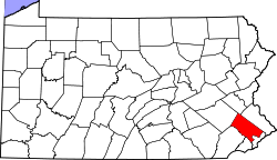
Sumneytown is an unincorporated community on Route 63 in Marlborough Township, Montgomery County, Pennsylvania, United States.[2] The Unami Creek forms its natural SE boundary with Salford and Upper Salford Townships and flows SW into the Perkiomen Creek. The historic Kings Highway passed through Sumneytown and the portion from there north to the Lehigh County line is named Geryville Pike today. 63 starts just to the NW in Green Lane and proceeds SE to the Lansdale/North Wales area as Sumneytown Pike. In 1848 the Sumneytown and Spring House Turnpike was opened to Marlborough and resulted in an influx of tourism from the wealthy families of Philadelphia.[3] This route is 63 to Kulpsville today. While Sumneytown has its own box post office with the zip code of 18084, some residents are served by the Green Lane PO with the zip of 18054.[4]
Notes