Upper Providence Township, Montgomery County, Pennsylvania
| Upper Providence Township | |
|---|---|
| Township | |
|
Black Rock Bridge over the Schuylkill River | |
 Location of Upper Providence Township in Montgomery County | |
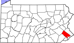
 Upper Providence Township Pennsylvania | |
| Coordinates: 40°07′24″N 75°27′29″W / 40.12333°N 75.45806°WCoordinates: 40°07′24″N 75°27′29″W / 40.12333°N 75.45806°W | |
| Country | United States |
| State | Pennsylvania |
| County | Montgomery |
| Area | |
| • Total | 18.2 sq mi (47 km2) |
| • Land | 17.8 sq mi (46 km2) |
| • Water | 0.4 sq mi (1 km2) |
| Elevation | 105 ft (32 m) |
| Population (2010) | |
| • Total | 21,219 |
| • Density | 1,200/sq mi (450/km2) |
| Time zone | EST (UTC-5) |
| • Summer (DST) | EDT (UTC-4) |
| Area code(s) | 610 |
| Website | http://www.uprov-montco.org |

Upper Providence Township is a township in Montgomery County, Pennsylvania, United States. As of the 2010 census, the township population was 21,219.
History
William Penn originally owned the land that is now Upper Providence. After selling off most of the land, he kept a large tract on the east side of the Schuylkill River, which included Upper and Lower Providence and parts of Perkiomen and Worchester. William Penn named the land “The Manor of Gilberts” after his mother’s maiden name.
The first person to settle in this area was Edward Lane, who bought 2,500 acres of land from William Penn in 1701. Edward and his wife established the Episcopal church in Lower Providence. In 1717 John Jacob Schrack came to the township from Germany. Schrack was able to convince Rev. Henry Melchior Muhlenberg to relocate to this area.[1] Muhlenberg was the founder of the Lutheran church in the United States. The first of which was founded in Trappe.
In March 1725 the farmers living on this land petitioned to form a new township called Providence. This land included Upper and Lower Providence.
Upper Providence Township was established in 1805 by the division of the former Providence Township along the Perkiomen Creek.[2] In 1896, the Boroughs of Collegeville and Trappe were created from northeastern portions of the township, yielding the present township boundaries.
The town of Trappe is the oldest village in the township. Samuel Seely bought 150 acres of land in 1762 and divided it into town lots. Seely named the town “Landau”.[3] The town was better known by a hotel called “The Trap” and when the town incorporated it selected Trappe over Landau..
Schuylkill Canal
The Schuylkill canal was built to help navigate past rapids on the Schuylkill river between Norristown and Pottstown. It was completed in 1825 and was about 5 miles long, extending from Black Rock dam (Lock 60) to Pawlings dam at the Perkiomen creek in Oaks (Lock 61). In the 1830s Lock 60 was doubled in size and again in 1840s the locks were expanded to handle wider boats.[4]
The river traffic helped the surrounding area grow. The settlement of Quincyville started at Lock 60 and the settlement of Lumberville grew at Lock 61. Lumberville thrived with stables for mules, and a general store for boat supplies. In the 1840s these towns changed names with Quincyville becoming Mont Clare and Lunberville becoming Port Providence, which are their current names.[4]
With the coming of railroads in the late 1800s, boat traffic died off. However it was supplemented by recreational boating in the 1920s. Pleasure boats ran between Philadelphia to Reading. In the 1950s the Army Corp of Engineers dredged the Schuylkill river to remove coal silt from upriver. The lower part of the canal was used as a holding basin for the silt.[4]
Railroads
The Philadelphia and Reading railroad ran through Upper Providence taking passengers from Philadelphia and Norristown to Pottstown, Reading and finally Pottsville. Before the railroad this trip had to be taken on stagecoaches or by horse. The railroad was constructed starting in Reading and down to Pottstown which opened in 1939. The last section between Bridgeport and Philadelphia was completed in 1842.[5] This rail line is still in use for freight only.
The Perkiomen Railroad was a second railroad passed through Upper Providence running from Oaks to Collegeville and then to Allentown. It was opened in 1868. This railroad was closed and it now part of the Perkiomen trail converted through the Rails to Trails initiative.
The Black Rock Bridge and Schuylkill Navigation Canal, Oakes Reach Section were listed on the National Register of Historic Places in 1988.[6]
Geography
According to the United States Census Bureau, the township has a total area of 18.2 square miles (47.2 km2), of which, 17.8 square miles (46.2 km2) of it is land and 0.4 square miles (1.0 km2) of it (2.09%) is water. Upper Providence is bordered to the northwest by Royersford Borough and Limerick Township; to the northeast by Perkiomen Township, Trappe Borough, and Collegeville Borough; to the southeast, separated by the Perkiomen Creek, is Lower Providence Township; and to the southwest, separated by the Schuylkill River, is Chester County.
Demographics
| Historical population | |||
|---|---|---|---|
| Census | Pop. | %± | |
| 1930 | 3,628 | — | |
| 1940 | 3,895 | 7.4% | |
| 1950 | 4,486 | 15.2% | |
| 1960 | 5,607 | 25.0% | |
| 1970 | 6,202 | 10.6% | |
| 1980 | 9,551 | 54.0% | |
| 1990 | 9,682 | 1.4% | |
| 2000 | 15,398 | 59.0% | |
| 2010 | 21,219 | 37.8% | |
| http://www.dvrpc.org/data/databull/rdb/db82/appedixa.xls. | |||
As of the 2010 census, the township was 86.6% White, 3.5% Black or African American, 0.1% Native American, 7.9% Asian, and 1.5% were two or more races. 2.2% of the population were of Hispanic or Latino ancestry .
As of the census[7] of 2000, there were 15,398 people, 5,355 households, and 4,101 families residing in the township. The population density was 862.9 people per square mile (333.3/km2). There were 5,545 housing units at an average density of 310.7/sq mi (120.0/km2). The racial makeup of the township was 93.51% White, 2.57% African American, 0.10% Native American, 2.77% Asian, 0.03% Pacific Islander, 0.27% from other races, and 0.76% from two or more races. Hispanic or Latino of any race were 1.34% of the population.
There were 5,355 households, out of which 42.2% had children under the age of 18 living with them, 65.6% were married couples living together, 8.4% had a female householder with no husband present, and 23.4% were non-families. 18.7% of all households were made up of individuals, and 4.1% had someone living alone who was 65 years of age or older. The average household size was 2.77 and the average family size was 3.20.
In the township the population was spread out, with 28.1% under the age of 18, 4.8% from 18 to 24, 37.5% from 25 to 44, 19.7% from 45 to 64, and 9.9% who were 65 years of age or older. The median age was 35 years. For every 100 females there were 90.8 males. For every 100 females age 18 and over, there were 87.4 males.
The median income for a household in the township was $75,789, and the median income for a family was $85,660. Males had a median income of $54,764 versus $37,193 for females. The per capita income for the township was $31,251. About 1.1% of families and 1.5% of the population were below the poverty line, including 1.6% of those under age 18 and 0.7% of those age 65 or over.
Government and politics
| Year | Republican | Democrat |
|---|---|---|
| 2012 | 50.7% 5,280 | 48.0% 4,993 |
| 2008 | 45.7% 4,681 | 53.5% 5,480 |
| 2004 | 53.6% 4,590 | 45.9% 3,928 |
| 2000 | 51.9% 3,198 | 45.0% 2,770 |
| 1996 | 45.1% 1,980 | 41.0% 1,802 |
| 1992 | 40.2% 1,682 | 35.7% 1,495 |
Upper Providence Township elects three supervisors at-large. The November 8, 2016 ballot included a question for residents on whether or not the Board-of-Supervisors should be expanded to a total of five members providing a better representation of the townships rapidly expanding population and demographics. The results of the ballot question are: YES - 4,560 (51%) and NO - 4,382 (49%) [8] resulting in the Board-of-Supervisors being expanded to five members.
- Philip Barker, Chairman
- Lisa Mossie, Vice-Chair
- Albert Vagnozzi
Communities
The following are unincorporated communities within Upper Providence.
Education
Upper Providence Township is a member of the Spring-Ford Area School District.
Economy
The Providence Town Center, an open-air lifestyle center, is located in Upper Providence Township at the interchange between U.S. Route 422 and Pennsylvania Route 29.
References
- ↑ "History of Potsgrove, Upper Lower and West Providence, Plymouth and Whitemarsh, Pa.". history.rays-place.com. Retrieved 2015-10-10.
- ↑ Bean, Theodore W., ed. (1884). HISTORY OF MONTGOMERY COUNTY PENNSYLVANIA, ILLUSTRATED, 1884. Philadelphia: Everts & Peck. p. 1056.
- ↑ "Full text of "History of Montgomery County, Pennsylvania"". archive.org. Retrieved 2015-10-10.
- 1 2 3 "Schuylkill Canal Association - The Canal's Past". schuylkillcanal.org. Retrieved 2015-10-10.
- ↑ Bean, Theodore Weber (1884-01-01). History of Montgomery County, Pennsylvania. Windmill Pub.
- ↑ National Park Service (2010-07-09). "National Register Information System". National Register of Historic Places. National Park Service.
- ↑ "American FactFinder". United States Census Bureau. Retrieved 2008-01-31.
- ↑ https://electionresults.montcopa.org/#/list?town=82&cview=ts
External links
- Upper Providence Township (official website)
- Upper Providence Township, CHAPTER LXXII, BEAN'S HISTORY OF MONTGOMERY COUNTY, PENNSYLVANIA, 1884
- 1871 Map of Upper Providence Township