Greenville, New Hampshire
| Greenville, New Hampshire | |
|---|---|
| Town | |
|
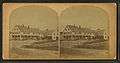
East Main Street in 1919 | |
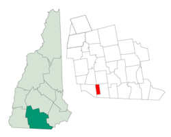 Location in Hillsborough County, New Hampshire | |
| Coordinates: 42°46′02″N 71°48′44″W / 42.76722°N 71.81222°WCoordinates: 42°46′02″N 71°48′44″W / 42.76722°N 71.81222°W | |
| Country | United States |
| State | New Hampshire |
| County | Hillsborough |
| Incorporated | 1872 |
| Government | |
| • Board of Selectmen |
Carla C. Mary Douglas A. Reardon Steve Spratt |
| • Town Administrator | Kelley Collins |
| Area | |
| • Total | 6.9 sq mi (17.8 km2) |
| • Land | 6.9 sq mi (17.8 km2) |
| • Water | 0.0 sq mi (0.0 km2) |
| Elevation | 830 ft (253 m) |
| Population (2010) | |
| • Total | 2,105 |
| • Density | 310/sq mi (120/km2) |
| Time zone | Eastern (UTC-5) |
| • Summer (DST) | Eastern (UTC-4) |
| ZIP code | 03048 |
| Area code(s) | 603 |
| FIPS code | 33-31940 |
| GNIS feature ID | 0873613 |
| Website | www.greenvillenh.org |

Greenville is a town in Hillsborough County, New Hampshire, United States. The population was 2,105 at the 2010 census.[1] It is located at the junction of New Hampshire routes 31, 45, and 123.
History
Once a part of Mason called Mason Village, Greenville is one of the state's newest and smallest towns, incorporated in 1872.[2] It is located at the High Falls on the Souhegan River, whose plentiful water power provided the mill town with the state's first industries, making cotton and woolen goods. Because of the falls, Greenville was always a manufacturing center. The Columbian Manufacturing Company was established in 1826 to make textiles in both Greenville and New Ipswich.[3] The Columbian is long gone, but its fine brick buildings still dominate the village, kept company by Queen Anne style houses on side streets. The mills are now used for other businesses and storage, and one has been converted into housing for the elderly.
Greenville once had a Boston & Maine Railroad trestle. Before it was dismantled for safety reasons, local residents turned out one sunny afternoon to watch Bronson Potter, Mason resident and inventor, fly a private airplane underneath the span on a wager. The railroad depot, which still stands, was once an important landmark that put the tiny towns of Mason and Greenville "on the map." It has since been turned into a Chinese restaurant and lounge.
 Columbian Hotel c. 1880
.jpg) Greenville in 1886
Greenville in 1886 View of the mills in 1886
 B. & M. trestle c. 1915
Geography
According to the United States Census Bureau, the town has a total area of 6.9 square miles (18 km2). The town center, or CDP, has an area of 3.4 sq mi (8.8 km2).
Greenville's highest point is Barrett Hill, with an elevation of 1,270 feet (390 m) above sea level. The town is drained by the Souhegan River. Greenville lies fully within the Merrimack River watershed.[4]
Greenville is bordered by New Ipswich to the west, Temple and Wilton to the north, and Mason to the east and south.
Roadways
Three state highways traverse Greenville. NH Route 31 enters the state in Mason from Ashby, Massachusetts, on MA Route 31. NH 31 intersects NH 124 before entering Greenville. NH 31 runs north-south for the entire length of the town before entering Wilton to the north. The highway shares a right-of-way with NH Route 123 which intersects it and runs north to Pleasant Street. Pleasant Street is the main access road to downtown Greenville from NH 31, aside from Mill Street, Old Mason Center Road, and Old Wilton Road. NH 123 continues on a left turn in downtown Greenville and runs south to New Ipswich and NH 124. Further down Main Street in Greenville is the beginning of NH Route 45, which runs northwest to Temple, ending at NH Route 101.
Demographics
| Historical population | |||
|---|---|---|---|
| Census | Pop. | %± | |
| 1880 | 1,072 | — | |
| 1890 | 1,255 | 17.1% | |
| 1900 | 1,608 | 28.1% | |
| 1910 | 1,374 | −14.6% | |
| 1920 | 1,346 | −2.0% | |
| 1930 | 1,319 | −2.0% | |
| 1940 | 1,236 | −6.3% | |
| 1950 | 1,280 | 3.6% | |
| 1960 | 1,385 | 8.2% | |
| 1970 | 1,587 | 14.6% | |
| 1980 | 1,988 | 25.3% | |
| 1990 | 2,231 | 12.2% | |
| 2000 | 2,224 | −0.3% | |
| 2010 | 2,105 | −5.4% | |
| Est. 2015 | 2,082 | [5] | −1.1% |
As of the census of 2000, there were 2,224 people, 879 households, and 556 families residing in the town. The population density was 323.8 people per square mile (125.0/km²). There were 918 housing units at an average density of 51.6 persons/km² (133.6 persons/sq mi). The racial makeup of the town was 97.84% White, 0.27% African American, 0.18% Native American, 0.36% Asian, 0.04% Pacific Islander, 0.13% from other races, and 1.17% from two or more races. 0.63% of the population were Hispanic or Latino of any race.
There were 879 households out of which 32.9% had children under the age of 18 living with them, 49.1% were married couples living together, 9.6% have a woman whose husband does not live with her, and 36.7% were non-families. 29.4% of all households were made up of individuals and 10.7% had someone living alone who was 65 years of age or older. The average household size was 2.53 and the average family size was 3.16.
In the town the population was spread out with 27.4% under the age of 18, 6.7% from 18 to 24, 32.1% from 25 to 44, 22.8% from 45 to 64, and 11.1% who were 65 years of age or older. The median age was 36 years. For every 100 females there were 102.0 males. For every 100 females age 18 and over, there were 104.6 males.
The median income for a household in the town was $39,545, and the median income for a family was $48,750. Males had a median income of $34,792 versus $26,295 for females. The per capita income for the town was $17,901. 7.4% of the population and 2.9% of families were below the poverty line. Out of the total people living in poverty, 5.7% are under the age of 18 and 18.5% are 65 or older.
Town center
As of the census of 2000, there were 1,131 people, 465 households, and 279 families residing in the central settlement (CDP). The population density was 333.7 people per square mile (128.8/km²). There were 487 housing units at an average density of 55.5 persons/km² (143.7 persons/sq mi). The racial makeup of the town was 98.14% White, 0.27% African American, 0.27% Native American, 0.35% Asian, 0.09% Pacific Islander, 0.09% from other races, and 0.80% from two or more races. 0.35% of the population were Hispanic or Latino of any race.
There were 465 households out of which 31.6% had children under the age of 18 living with them, 47.3% were married couples living together, 8.8% have a woman whose husband does not live with her, and 39.8% were non-families. 34.2% of all households were made up of individuals and 15.9% had someone living alone who was 65 years of age or older. The average household size was 2.43 and the average family size was 3.15.
In the CDP the population was spread out with 26.1% under the age of 18, 7.4% from 18 to 24, 31.2% from 25 to 44, 21.0% from 45 to 64, and 14.2% who were 65 years of age or older. The median age was 37 years. For every 100 females there were 98.1 males. For every 100 females age 18 and over, there were 101.4 males.
The median income for a household is $42,917, and the median income for a family was $48,889. Males had a median income of $38,875 versus $23,472 for females. The per capita income for the town was $17,850. 5.0% of the population and 1.4% of families were below the poverty line. Out of the total people living in poverty, 3.4% are under the age of 18 and 17.7% are 65 or older.
Notable people
- Brian Viglione, drummer for The Dresden Dolls
References
- ↑ United States Census Bureau, American FactFinder, 2010 Census figures. Retrieved March 23, 2011.
- ↑ New Hampshire Economic and Labor Market Information Bureau Profile
- ↑ Coolidge, Austin J.; John B. Mansfield (1859). A History and Description of New England. Boston, Massachusetts. pp. 574–575.
- ↑ Foster, Debra H.; Batorfalvy, Tatianna N.; Medalie, Laura (1995). Water Use in New Hampshire: An Activities Guide for Teachers. U.S. Department of the Interior and U.S. Geological Survey.
- ↑ "Annual Estimates of the Resident Population for Incorporated Places: April 1, 2010 to July 1, 2015". Retrieved July 2, 2016.
- ↑ "Census of Population and Housing". Census.gov. Retrieved June 4, 2016.
External links
- Town of Greenville official website
- Chamberlin Free Public Library
- New Hampshire Economic and Labor Market Information Bureau Profile
Municipalities and communities of Hillsborough County, New Hampshire, United States | ||
|---|---|---|
| Cities | 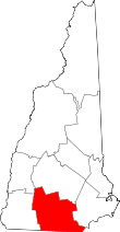 | |
| Towns | ||
| CDPs | ||
| Other villages | ||