Pelham, New Hampshire
| Pelham, New Hampshire | ||
|---|---|---|
| Town | ||
|
The Congregational church in the town center | ||
| ||
 Location in Hillsborough County, New Hampshire | ||
| Coordinates: 42°44′04″N 71°19′28″W / 42.73444°N 71.32444°WCoordinates: 42°44′04″N 71°19′28″W / 42.73444°N 71.32444°W | ||
| Country | United States | |
| State | New Hampshire | |
| County | Hillsborough | |
| Incorporated | 1746 | |
| Government | ||
| • Board of Selectmen |
Douglas Viger, Chair Harold Lynde William McDevitt Paul Leonard Amy Spencer | |
| • Town Administrator | Brian McCarthy | |
| Area | ||
| • Total | 27.0 sq mi (69.8 km2) | |
| • Land | 26.4 sq mi (68.5 km2) | |
| • Water | 0.5 sq mi (1.3 km2) 1.93% | |
| Elevation | 154 ft (47 m) | |
| Population (2010) | ||
| • Total | 12,897 | |
| • Density | 480/sq mi (180/km2) | |
| Time zone | Eastern (UTC-5) | |
| • Summer (DST) | Eastern (UTC-4) | |
| ZIP code | 03076 | |
| Area code(s) | 603 | |
| FIPS code | 33-59940 | |
| GNIS feature ID | 0873695 | |
| Website |
www | |

Pelham /ˈpɛləm/ is a town in Hillsborough County, New Hampshire, United States. The population was 12,897 at the 2010 census.[1]
History
Pelham was split from Old Dunstable in 1741, when the border between Massachusetts and New Hampshire was settled. It was incorporated in 1746. The town is named after Thomas Pelham-Holles, 1st Duke of Newcastle.[2]
Geography
According to the United States Census Bureau, the town has a total area of 27.0 square miles (69.9 km2), of which 26.4 sq mi (68.4 km2) is land and 0.5 sq mi (1.3 km2) is water, comprising 1.93% of the town. The highest point in Pelham is Jeremy Hill, at 577 feet (176 m) above sea level. The town contains the southernmost point in the state of New Hampshire, at 42°41′49″N 71°17′40″W / 42.69694°N 71.29444°W, a location known as the "Old Boundary Pine", named for a pine tree that marked the difference in definition of the northern boundary of Massachusetts. This point is 3 miles due north of Pawtucket Falls, and marks the point where the straight-line border to the west meets the 3 mile buffer defined by the Merrimack River.[3]
Demographics
| Historical population | |||
|---|---|---|---|
| Census | Pop. | %± | |
| 1790 | 791 | — | |
| 1800 | 918 | 16.1% | |
| 1810 | 998 | 8.7% | |
| 1820 | 1,040 | 4.2% | |
| 1830 | 1,070 | 2.9% | |
| 1840 | 1,003 | −6.3% | |
| 1850 | 1,071 | 6.8% | |
| 1860 | 944 | −11.9% | |
| 1870 | 861 | −8.8% | |
| 1880 | 848 | −1.5% | |
| 1890 | 791 | −6.7% | |
| 1900 | 875 | 10.6% | |
| 1910 | 826 | −5.6% | |
| 1920 | 974 | 17.9% | |
| 1930 | 814 | −16.4% | |
| 1940 | 979 | 20.3% | |
| 1950 | 1,317 | 34.5% | |
| 1960 | 2,605 | 97.8% | |
| 1970 | 5,408 | 107.6% | |
| 1980 | 8,090 | 49.6% | |
| 1990 | 9,408 | 16.3% | |
| 2000 | 10,914 | 16.0% | |
| 2010 | 12,897 | 18.2% | |
| Est. 2015 | 13,303 | [4] | 3.1% |
The earliest census data shows the town of Pelham having a population of 543 residents in 1767.[6]
As of the census[7] of 2000, there were 10,914 people, 3,606 households, and 2,982 families residing in the town. The population density was 412.9 people per square mile (159.4/km²). There were 3,740 housing units at an average density of 141.5 per square mile (54.6/km²). The racial makeup of the town was:
- 97.34% White (U.S. average: 75.1%)
- 0.44% African American (U.S. average: 12.3%)
- 0.22% Native American (U.S. average: 0.1%)
- 1.04% Asian (U.S. average: 3.6%)
- 0.25% from other races (U.S. average: 5.5%)
- 0.71% from two or more races (U.S. average: 2.4%)
Hispanic or Latino of any race were 0.96% of the population. (U.S. average: 12.5%)
In 2000, there were 3,606 households, with an average household size of 3.03 and an average family size of 3.33.
- 43.6% of households had children under the age of 18 living with them. (U.S. average: 32.8%)
- 71.8% were married couples living together. (U.S. average: 51.7%)
- 7.5% had a female householder with no husband present. (U.S. average: 12.2%)
- 17.3% were non-families. (U.S. average: 31.9%)
- 12.9% of all households were made up of individuals. (U.S. average: 25.8%)
- 5.7% had someone living alone who was 65 years of age or older. (U.S. average: 9.2%)
In 2000, the town's population had a median age of 36 years (U.S. average: 35.3).
- 28.9% under the age of 18
- 6.1% from 18 to 24
- 34.0% from 25 to 44
- 23.2% from 45 to 64
- 7.8% who were 65 years of age or older
For every 100 females there were 98.8 males. For every 100 females age 18 and over, there were 99.3 males.
The median income for a household in the town was $68,608. (U.S. average: $41,994). The median income for a family was $73,365. (U.S. average: $50,046). Males had a median income of $47,685 versus $33,375 for females. The per capita income for the town was $25,158. About 1.6% of families (U.S. average: 9.2%) and 3.0% of the population (U.S. average: 12.4%) were below the poverty line, including 3.1% of those under age 18 and 4.7% of those age 65 or over.
School system

- Pelham Elementary School
- Pelham Memorial School
- Pelham High School
- St. Patrick School (private) (former parochial school)
- E. G. Sherburne School (former elementary school)
Transportation
Pelham is crossed by three New Hampshire state routes:
- NH 38 enters the town from the south at the Massachusetts border, and curves to the northeast, exiting the town into Salem. It follows Bridge Street through town, and serves as the commercial hub of Pelham.
- NH 111A begins at a junction with NH 128 just north of the Massachusetts border, going primarily northeast, exiting the town into Windham. It is known as Marsh Road and Windham Road within Pelham.
- NH 128 is part of the larger Mammoth Road which connects Lowell, Massachusetts to Hooksett, New Hampshire. It enters the town from Massachusetts border, and goes due north, along the western edge of the town, before exiting the town into Windham.
Pelham has no air or rail transport within the town limits. The nearest commercial airport is Manchester–Boston Regional Airport along the border of Londonderry and Manchester. The nearest rail service is the Lowell Line of the MBTA Commuter Rail which can be accessed at the Charles A. Gallagher Transit Terminal in Lowell, Massachusetts. The nearest Amtrak stations are Boston's North Station or South Station.
Parks
Muldoon Park
The park is located northwest of the center of Pelham at 305 Mammoth Road (NH 128), just north of Nashua Road. The park's land area is surrounded by NH 128, two roads that branch off it, and a minor road which intersects NH 111A.
Muldoon Park offers many short walking trails, four variously sized baseball fields (ranging from t-ball to official), a soccer field, and a play area. Most of the trails lead to the park's two ponds, local roads and houses or to Beaver Brook, a small river. The town of Pelham completed an 18-hole disc golf course here, stretching over a quarter-mile, in September 2007.[8]
The Pelham Parks and Recreation department has recently added two non-official sized baseball fields to the southwest corner of the park. Construction is complete on one field with the exception of dugouts, and the other field is still under construction, as of September 2013.
There is now an 18-hole disc golf course at this park. Many players from surrounding towns enjoy a round of disc golf set in the woods adjacent to the sport fields.
Notable people
- Josiah Butler (1779–1854), US congressman[9]
- Sean Caisse (1986-), stock car driver
- Ray Fox, crew chief and owner with NASCAR
- Daniel Gage (1828–1901), the "Ice King of Lowell"; family for whom Gage Hill is named
- Nick Groff (1980-), paranormal investigator; graduate of Pelham High School (1999)
- Gary Hoey, surfer-rock musician
- Richard M. Linnehan, astronaut (NASA); graduate of Pelham High School (1975)
See also
References
- ↑ United States Census Bureau, American FactFinder, 2010 Census figures. Retrieved March 23, 2011.
- ↑ "Profile for Pelham, New Hampshire". ePodunk. Retrieved 2010-04-25.
- ↑ U.S. Geological Survey. "Lowell, Massachusetts—New Hampshire" 7.5 x 15 minute quadrangle. 1987.
- ↑ "Annual Estimates of the Resident Population for Incorporated Places: April 1, 2010 to July 1, 2015". Retrieved July 2, 2016.
- ↑ "Census of Population and Housing". Census.gov. Retrieved June 4, 2016.
- ↑ http://www.nh.gov/oep/programs/DataCenter/Population/1767-820.htm#hillsborough
- ↑ "American FactFinder". United States Census Bureau. Retrieved 2008-01-31.
- ↑ The Eagle-Tribune, October 15, 2007
- ↑ The twentieth century biographical dictionary of notable Americans ... edited by Rossiter Johnson, John Ho
External links
- Town website
- New Hampshire Economic and Labor Market Information Bureau Profile
- Pelham Police Department
Municipalities and communities of Hillsborough County, New Hampshire, United States | ||
|---|---|---|
| Cities | 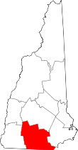 | |
| Towns | ||
| CDPs | ||
| Other villages | ||