Granvinsvatnet
| Granvinsvatnet | |
|---|---|
| Location | Granvin, Hordaland |
| Coordinates | 60°33′08″N 6°42′52″E / 60.5523°N 6.7145°ECoordinates: 60°33′08″N 6°42′52″E / 60.5523°N 6.7145°E |
| Basin countries | Norway |
| Max. length | 4.4 kilometres (2.7 mi) |
| Max. width | 1.2 kilometres (0.75 mi) |
| Surface area | 4.05 km2 (1.56 sq mi) |
| Shore length1 | 10.97 kilometres (6.82 mi) |
| Surface elevation | 24 metres (79 ft) |
| References | NVE |
| 1 Shore length is not a well-defined measure. | |
Granvinsvatnet is a lake in the municipality of Granvin in Hordaland county, Norway. The 4.05-square-kilometre (1.56 sq mi) lake sits just north of the municipal centre of Eide in the central part of the municipality.
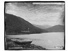
View of the lake and Granvin Church
The Norwegian National Road 13 exits the Tunsberg Tunnel just northwest of the lake and then runs along the northern and eastern shores of the lake before entering the Vallavik Tunnel just off the southeastern tip of the lake. The planned Joberg Tunnel is scheduled to be built along the northern part of this lake. The old Hardanger Line railway used to run along the west side of the lake. Granvin Church lies along the eastern shore of the lake.[1]
See also
References
- ↑ Store norske leksikon. "Granvinvatnet" (in Norwegian). Retrieved 2014-05-20.
This article is issued from Wikipedia - version of the 5/21/2014. The text is available under the Creative Commons Attribution/Share Alike but additional terms may apply for the media files.