Storakersvatnet
| Storakersvatnet | |
|---|---|
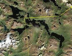 Satellite view of Storakersvatnet (upper left lake) | |
| Location | Rana, Nordland |
| Coordinates | 66°10′23″N 14°24′48″E / 66.17306°N 14.41333°E / 66.17306; 14.41333Coordinates: 66°10′23″N 14°24′48″E / 66.17306°N 14.41333°E / 66.17306; 14.41333 |
| Basin countries | Norway |
| Surface area | 42.30 km2 (16.33 sq mi) |
| Shore length1 | 78.60 km (48.84 mi) |
| Surface elevation | 523 m (1,716 ft) |
| References | NVE |
| 1 Shore length is not a well-defined measure. | |
Storakersvatnet is a lake in the municipality of Rana in Nordland county, Norway. The lake lies about 15 kilometres (9.3 mi) south of the town of Mo i Rana and less than 900 metres (3,000 ft) from the border with Sweden. The original lake was only 15.9 square kilometres (6.1 sq mi), but a dam was built at the northern end so that it can serve as a reservoir for the Rana power station. This dam has caused the lake to enlarge to an area of 42.3 square kilometres (16.3 sq mi).[1]
See also
References
- ↑ Store norske leksikon. "Store Akersvatn" (in Norwegian). Retrieved 2011-12-15.
This article is issued from Wikipedia - version of the 9/4/2015. The text is available under the Creative Commons Attribution/Share Alike but additional terms may apply for the media files.