Grant, Nebraska
| Grant, Nebraska | |
|---|---|
| City | |
|
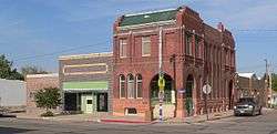
The Grant Commercial Historic District is listed in the National Register of Historic Places.[2] | |
 Location within Perkins County and Nebraska | |
| Coordinates: 40°50′40″N 101°43′34″W / 40.84444°N 101.72611°WCoordinates: 40°50′40″N 101°43′34″W / 40.84444°N 101.72611°W | |
| Country | United States |
| State | Nebraska |
| County | Perkins |
| Area[3] | |
| • Total | 0.73 sq mi (1.89 km2) |
| • Land | 0.73 sq mi (1.89 km2) |
| • Water | 0 sq mi (0 km2) |
| Elevation | 3,412 ft (1,040 m) |
| Population (2010)[4] | |
| • Total | 1,165 |
| • Estimate (2012[5]) | 1,148 |
| • Density | 1,600/sq mi (620/km2) |
| Time zone | Mountain (MST) (UTC-7) |
| • Summer (DST) | MDT (UTC-6) |
| ZIP code | 69140 |
| Area code(s) | 308 |
| FIPS code | 31-19910 [6] |
| GNIS feature ID | 0829641 [7] |
| Website | grantnebraska.com |
Grant is a city and county seat of Perkins County, Nebraska, United States.[8] The population was 1,165 at the 2010 census.
History
Grant was platted in 1886 when the Chicago, Burlington and Quincy Railroad was extended to that point.[9][10] The city is named for Ulysses S. Grant, 18th President of the United States.[11]
Geography
Grant is located at 40°50′40″N 101°43′34″W / 40.84444°N 101.72611°W (40.844405, -101.726109).[12] According to the United States Census Bureau, the city has a total area of 0.73 square miles (1.89 km2), all of it land.[3]
Demographics
| Historical population | |||
|---|---|---|---|
| Census | Pop. | %± | |
| 1890 | 315 | — | |
| 1900 | 162 | −48.6% | |
| 1910 | 358 | 121.0% | |
| 1920 | 585 | 63.4% | |
| 1930 | 798 | 36.4% | |
| 1940 | 897 | 12.4% | |
| 1950 | 1,091 | 21.6% | |
| 1960 | 1,166 | 6.9% | |
| 1970 | 1,099 | −5.7% | |
| 1980 | 1,270 | 15.6% | |
| 1990 | 1,239 | −2.4% | |
| 2000 | 1,225 | −1.1% | |
| 2010 | 1,165 | −4.9% | |
| Est. 2015 | 1,133 | [13] | −2.7% |
| U.S. Decennial Census | |||
2010 census
As of the census[4] of 2010, there were 1,165 people, 520 households, and 317 families residing in the city. The population density was 1,595.9 inhabitants per square mile (616.2/km2). There were 588 housing units at an average density of 805.5 per square mile (311.0/km2). The racial makeup of the city was 97.7% White, 0.1% African American, 0.4% Native American, 0.4% Asian, 1.0% from other races, and 0.3% from two or more races. Hispanic or Latino of any race were 2.7% of the population.
There were 520 households of which 26.2% had children under the age of 18 living with them, 53.5% were married couples living together, 4.8% had a female householder with no husband present, 2.7% had a male householder with no wife present, and 39.0% were non-families. 36.5% of all households were made up of individuals and 21.2% had someone living alone who was 65 years of age or older. The average household size was 2.16 and the average family size was 2.79.
The median age in the city was 46.4 years. 23.3% of residents were under the age of 18; 5.6% were between the ages of 18 and 24; 19.9% were from 25 to 44; 26.4% were from 45 to 64; and 24.8% were 65 years of age or older. The gender makeup of the city was 47.6% male and 52.4% female.
2000 census
As of the census[6] of 2000, there were 1,225 people, 535 households, and 331 families residing in the city. The population density was 1,674.6 people per square mile (647.9/km²). There were 591 housing units at an average density of 807.9 per square mile (312.6/km²). The racial makeup of the city was 98.78% White, 0.33% Native American, 0.16% Asian, 0.24% from other races, and 0.49% from two or more races. Hispanic or Latino of any race were 1.22% of the population.
There were 535 households out of which 28.4% had children under the age of 18 living with them, 54.6% were married couples living together, 5.8% had a female householder with no husband present, and 38.1% were non-families. 36.8% of all households were made up of individuals and 25.8% had someone living alone who was 65 years of age or older. The average household size was 2.19 and the average family size was 2.86.
In the city the population was spread out with 23.4% under the age of 18, 4.4% from 18 to 24, 21.6% from 25 to 44, 22.8% from 45 to 64, and 27.8% who were 65 years of age or older. The median age was 45 years. For every 100 females there were 86.5 males. For every 100 females age 18 and over, there were 80.7 males.
As of 2000 the median income for a household in the city was $31,625, and the median income for a family was $42,692. Males had a median income of $30,050 versus $20,673 for females. The per capita income for the city was $18,909. About 6.1% of families and 8.9% of the population were below the poverty line, including 12.2% of those under age 18 and 9.8% of those age 65 or over.
Notable people
- Danielle Anderson, singer, writer, ukulele player; stage name Danielle Ate The Sandwich
- Gary Glick, American football player
- Claire Schreiner, Miss Wyoming USA 2010
References
- ↑ "Nebraska National Register Sites in Perkins County". Nebraska State Historical Society. Retrieved 2012-09-20.
- ↑ "Nebraska National Register Sites in Perkins County". Nebraska State Historical Society. Retrieved 2012-09-20.
- 1 2 "US Gazetteer files 2010". United States Census Bureau. Retrieved 2012-06-24.
- 1 2 "American FactFinder". United States Census Bureau. Retrieved 2012-06-24.
- ↑ "Population Estimates". United States Census Bureau. Retrieved 2013-05-29.
- 1 2 "American FactFinder". United States Census Bureau. Retrieved 2008-01-31.
- ↑ "US Board on Geographic Names". United States Geological Survey. 2007-10-25. Retrieved 2008-01-31.
- ↑ "Find a County". National Association of Counties. Retrieved 2011-06-07.
- ↑ Burr, George L. (1921). History of Hamilton and Clay Counties, Nebraska, Volume 1. S.J. Clarke Publishing Company. p. 132.
- ↑ "Grant, Perkins County". Center for Advanced Land Management Information Technologies. University of Nebraska. Retrieved 21 August 2014.
- ↑ Gannett, Henry (1905). The Origin of Certain Place Names in the United States. Govt. Print. Off. p. 141.
- ↑ "US Gazetteer files: 2010, 2000, and 1990". United States Census Bureau. 2011-02-12. Retrieved 2011-04-23.
- ↑ "Annual Estimates of the Resident Population for Incorporated Places: April 1, 2010 to July 1, 2015". Retrieved July 2, 2016.
External links
| Wikimedia Commons has media related to Grant, Nebraska. |
Municipalities and communities of Perkins County, Nebraska, United States | ||
|---|---|---|
| City | ||
| Villages | ||
| Unincorporated communities | ||