Grade II* listed buildings in Eden District
There are over 20,000 Grade II* listed buildings in England. This page is a list of these buildings in the district of Eden in Cumbria.
Eden
| Name | Location | Type | Completed [note 1] | Date designated | Grid ref.[note 2] Geo-coordinates |
Entry number [note 3] | Image |
|---|---|---|---|---|---|---|---|
| Byre West of Townhead | Newbiggin, Ainstable, Eden | Bastle | Mid 16th century | 3 August 1984 | NY5628049083 54°50′05″N 2°40′56″W / 54.834653°N 2.682176°W |
1137235 | 
|
| The Old Pele and Rectory Farmhouse and Barn | Croglin, Ainstable, Eden | House | Early 15th century | 3 August 1984 | NY5754147276 54°49′07″N 2°39′44″W / 54.818524°N 2.662279°W |
1327028 |
|
| Clarghyll Hall | Alston Moor, Eden | Bastle | 16th century | 25 September 1951 | NY7257249324 54°50′17″N 2°25′43″W / 54.837979°N 2.428569°W |
1087069 | .jpg) |
| Market Cross | Alston, Alston Moor, Eden | Market Cross | 1764 | 25 September 1951 | NY7188646498 54°48′45″N 2°26′20″W / 54.812546°N 2.438973°W |
1325968 | .jpg) |
| Church of St Michael | Appleby-in-Westmorland, Eden | Church | 13th century | 6 June 1951 | NY6886419885 54°34′24″N 2°28′59″W / 54.573215°N 2.483142°W |
1137750 |  |
| High Cross | Appleby-in-Westmorland, Eden | Column | 17th century | 6 June 1951 | NY6843420137 54°34′32″N 2°29′23″W / 54.575452°N 2.489821°W |
1311978 |  |
| Lamp Post on North Side of High Cross | Appleby-in-Westmorland, Eden | Lamp Post | Late 19th century | 21 March 1985 | NY6843220140 54°34′32″N 2°29′23″W / 54.575479°N 2.489852°W |
1145608 |
|
| Low Cross | Appleby-in-Westmorland, Eden | Column | 18th century | 6 June 1951 | NY6833820391 54°34′40″N 2°29′29″W / 54.577729°N 2.491333°W |
1138035 |  |
| Moot Hall | Appleby-in-Westmorland, Eden | Hall | 1596 | 6 June 1951 | NY6835320347 54°34′38″N 2°29′28″W / 54.577334°N 2.491096°W |
1145607 |  |
| St Anne's Hospital Chapel at St Anne's Hospital | Appleby-in-Westmorland, Eden | House | 1651-53 | 6 June 1951 | NY6843420200 54°34′34″N 2°29′23″W / 54.576019°N 2.489827°W |
1145571 |  |
| The Cloisters | Appleby-in-Westmorland, Eden | Tower | 1811 | 6 June 1951 | NY6833220406 54°34′40″N 2°29′29″W / 54.577863°N 2.491428°W |
1319048 |
|
| 30 Boroughgate | Appleby-in-Westmorland, Eden | House | 1717 | 6 June 1951 | NY6836720280 54°34′36″N 2°29′27″W / 54.576733°N 2.490872°W |
1146473 |
|
| Asby Hall, Area Railings and Central Gate | Great Asby, Asby, Eden | House | 1694 | 6 February 1968 | NY6826713270 54°30′49″N 2°29′30″W / 54.513732°N 2.491661°W |
1144927 |
|
| Gaythorne Hall | Asby, Eden | Country House | 16th century | 6 February 1968 | NY6496113278 54°30′49″N 2°32′34″W / 54.513585°N 2.542724°W |
1137181 | .jpg) |
| Old Rectory | Great Asby, Asby, Eden | House | 1984 | 6 February 1968 | NY6804713154 54°30′46″N 2°29′42″W / 54.512675°N 2.495046°W |
1326996 |
|
| Well to East of Grange Hall | Asby, Eden | Well House | Mediaeval | 12 April 1984 | NY6855310893 54°29′33″N 2°29′13″W / 54.492388°N 2.486989°W |
1144934 |
|
| Church of St Peter | Askham, Eden | Parish Church | Medieval | 6 February 1968 | NY5181823856 54°36′27″N 2°44′51″W / 54.607558°N 2.747452°W |
1145271 | .jpg) |
| Church of St Patrick | Bampton, Eden | Parish Church | Medieval | 6 February 1968 | NY5215718040 54°33′19″N 2°44′29″W / 54.555327°N 2.741254°W |
1145258 |  |
| Barton Church Farmhouse | Barton, Eden | Farmhouse | Late 16th century | 6 February 1968 | NY4852426433 54°37′49″N 2°47′56″W / 54.630388°N 2.798896°W |
1145234 |
|
| Glebe Farmhouse | Barton, Eden | House | 1637 | 6 February 1968 | NY4860726394 54°37′48″N 2°47′51″W / 54.630046°N 2.797604°W |
1336948 |
|
| Bewley Castle | Bolton, Eden | Castle | 6 February 1968 | NY6478421149 54°35′03″N 2°32′47″W / 54.584305°N 2.546403°W |
1065873 |
| |
| Crossrigg Hall | Bolton, Eden | House | c. 1864 | 12 April 1984 | NY6058724148 54°36′39″N 2°36′42″W / 54.610944°N 2.611742°W |
1357502 | .jpg) |
| Church of St Michael | Church Brough, Brough, Eden | Parish Church | 12th century | 12 September 1957 | NY7931513921 54°31′13″N 2°19′16″W / 54.520156°N 2.321063°W |
1144902 |  |
| Alms Table Beside Countess's Pillar | Brougham, Eden | Commemorative Monument | 1656 | 3 September 1987 | NY5461828957 54°39′13″N 2°42′18″W / 54.653655°N 2.704899°W |
1099102 |
|
| Chapel of St Wilfred of Brougham Chapel | Brougham, Eden | Chapel | Medieval | 6 February 1968 | NY5276528401 54°38′55″N 2°44′01″W / 54.648488°N 2.733527°W |
1349045 | .jpg) |
| Countess's Pillar | Brougham, Eden | Sundial | 1654? | 6 February 1968 | NY5461428957 54°39′13″N 2°42′18″W / 54.653655°N 2.704961°W |
1326777 |  |
| Curtain Walls, Gateway Buildings, Stables, and Domestic Ranges Forming Part of Brougham Hall | Brougham, Eden | House | Late 15th century or Early 16th century | 20 May 1975 | NY5279828378 54°38′54″N 2°43′59″W / 54.648285°N 2.733012°W |
1145355 |  |
| Hornby Hall and Barns Adjoining | Brougham, Eden | Farmhouse | Early - mid 16th century | 6 February 1968 | NY5693129930 54°39′45″N 2°40′09″W / 54.662602°N 2.669196°W |
1326775 |
|
| Ruins of Brougham Hall | Brougham, Eden | House | Early 19th century | 20 May 1975 | NY5279428350 54°38′53″N 2°43′59″W / 54.648033°N 2.733069°W |
1099141 |  |
| Church of St Kentigern | Castle Sowerby, Eden | Parish Church | 12th century | 27 December 1967 | NY3799936145 54°42′59″N 2°57′50″W / 54.716469°N 2.963974°W |
1326686 |  |
| The Ashes | Highbridge, Castle Sowerby, Eden | House | Mid 16th century | 27 December 1967 | NY3916242707 54°46′32″N 2°56′50″W / 54.775573°N 2.947299°W |
1319031 |
|
| Church of St John | Newton Reigny, Catterlen, Eden | Sundial | Late 12th century | 27 December 1967 | NY4798431601 54°40′36″N 2°48′29″W / 54.676771°N 2.808182°W |
1145530 |  |
| Church of St Cuthbert | Clifton, Eden | Parish Church | 12th century | 6 February 1968 | NY5319027045 54°38′11″N 2°43′36″W / 54.636343°N 2.726723°W |
1348695 |  |
| Nether Hoff Farmhouse | Colby, Eden | Farmhouse | 1683 | 6 February 1968 | NY6674620043 54°34′28″N 2°30′57″W / 54.574499°N 2.515921°W |
1327000 |
|
| Smardalegill Viaduct over Scandal Beck | Crosby Garrett, Crosby Garrett, Eden | Railway Viaduct | 1860 | 17 December 1984 | NY7268706904 54°27′24″N 2°25′22″W / 54.456781°N 2.422801°W |
1137239 |  |
| The Old Rectory | Crosby Garrett, Eden | House | FROM 1637 | 6 February 1968 | NY7298009621 54°28′52″N 2°25′07″W / 54.481213°N 2.418531°W |
1145022 | .jpg) |
| 2 Summer Houses on Bowling Green Immediately to South of Maulds Meaburn Hall | Maulds Meaburn, Crosby Ravensworth, Eden | Summerhouse | Pre C18? | 6 February 1968 | NY6240017011 54°32′49″N 2°34′58″W / 54.546947°N 2.582757°W |
1145420 |
|
| Flass House | Maulds Meaburn, Crosby Ravensworth, Eden | Villa | c1848-1861 | 6 February 1968 | NY6275215682 54°32′06″N 2°34′38″W / 54.53503°N 2.577147°W |
1145414 |  |
| Garden Walls and Gatepiers to Front of Maulds Meaburn Hall | Maulds Meaburn, Crosby Ravensworth, Eden | Gate Pier | c. 1676 | 6 February 1968 | NY6243917083 54°32′51″N 2°34′56″W / 54.547597°N 2.582163°W |
1157873 |
|
| Holesfoot House | Crosby Ravensworth, Eden | House | c. 1845 | 6 February 1968 | NY6413217351 54°33′00″N 2°33′22″W / 54.550129°N 2.556026°W |
1145441 |
|
| Maulds Meaburn Hall | Maulds Meaburn, Crosby Ravensworth, Eden | House | Late 16th century | 6 February 1968 | NY6239817075 54°32′51″N 2°34′58″W / 54.547522°N 2.582796°W |
1326730 |
|
| Reagill Grange | Reagill, Crosby Ravensworth, Eden | House | Late 16th century | 6 February 1968 | NY6077616990 54°32′48″N 2°36′28″W / 54.546635°N 2.607857°W |
1157943 |
|
| Church of St John | Skirwith, Culgaith, Eden | Parish Church | 1856 | 23 June 1992 | NY6176532565 54°41′12″N 2°35′41″W / 54.686671°N 2.594608°W |
1273399 |
|
| Millrigg and Dwelling Adjoining to North West | Culgaith, Eden | House | 1597 | 27 December 1967 | NY6079428260 54°38′52″N 2°36′33″W / 54.647911°N 2.609089°W |
1107926 |  |
| Skirwith Vicarage and Attached Coach House and Stables | Skirwith, Culgaith, Eden | Vicarage | 1856 | 9 September 1993 | NY6173432456 54°41′08″N 2°35′42″W / 54.68569°N 2.595074°W |
1115119 |
|
| Carved Bear North East of Church of St Andrew | Dacre, Eden | Statue | Medieval | 24 October 1986 | NY4603026656 54°37′56″N 2°50′15″W / 54.632131°N 2.837566°W |
1252583 |  |
| Carved Bear North West of Church of St Andrew | Dacre, Eden | Statue | Medieval | 24 October 1986 | NY4597226649 54°37′55″N 2°50′18″W / 54.632062°N 2.838463°W |
1145532 |  |
| Carved Bear South East of Church of St Andrew | Dacre, Eden | Statue | Medieval | 24 October 1986 | NY4603526631 54°37′55″N 2°50′15″W / 54.631907°N 2.837484°W |
1252582 |  |
| Carved Bear South West of Church of St Andrew | Dacre, Eden | Statue | Medieval | 24 October 1986 | NY4596526608 54°37′54″N 2°50′19″W / 54.631693°N 2.838564°W |
1262197 |  |
| Fort Putnam Farmhouse, Barns, Byres, Cow House, Wall and Gateway | Greystoke, Dacre, Eden | Farmhouse | Late 18th century | 27 December 1967 | NY4519730940 54°40′14″N 2°51′05″W / 54.670536°N 2.851273°W |
1145543 |  |
| Church of St Michael | Glassonby, Eden | Church | Earlier than early 16th century | 27 December 1967 | NY5743538308 54°44′17″N 2°39′45″W / 54.73793°N 2.66261°W |
1144844 |  |
| Outbuilding to East of White House Farmhouse | Glassonby, Eden | Bastle | Late 16th century | 3 August 1984 | NY5774638937 54°44′37″N 2°39′28″W / 54.743608°N 2.657872°W |
1137290 |
|
| Church of St Cuthbert | Great Salkeld, Eden | Altar | Roman | 27 December 1967 | NY5516536764 54°43′26″N 2°41′51″W / 54.723858°N 2.697625°W |
1100260 | 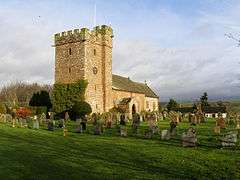 |
| The Rectory | Great Salkeld, Eden | Fortified House | Early 15th century | 27 December 1967 | NY5515636600 54°43′21″N 2°41′52″W / 54.722383°N 2.697739°W |
1100254 |
|
| Church of St Andrew | Greystoke, Eden | Parish Church | 13th century | 27 December 1967 | NY4433530785 54°40′09″N 2°51′53″W / 54.669048°N 2.864607°W |
1210233 |  |
| Greenthwaite Hall Cottage, Greenthwaite Hall Farmhouse | Greystoke, Eden | Farmhouse | Mid 16th century | 27 December 1967 | NY4315430207 54°39′49″N 2°52′58″W / 54.663723°N 2.882804°W |
1145515 |
|
| Greystoke Castle | Greystoke Park, Greystoke, Eden | Castle | Medieval | 27 December 1967 | NY4354330893 54°40′12″N 2°52′37″W / 54.669931°N 2.876907°W |
1290545 |  |
| Johnby Hall | Johnby, Greystoke, Eden | Fortified House | Late 14th century | 27 December 1967 | NY4341832758 54°41′12″N 2°52′45″W / 54.686675°N 2.879207°W |
1326690 |  |
| Watson Farmhouse | Greystoke Gill, Greystoke, Eden | Farmhouse | Late 18th century | 24 October 1986 | NY4447429535 54°39′28″N 2°51′44″W / 54.657832°N 2.862214°W |
1210286 |
|
| Helbeck Hall with Retaining Wall to Rear | Helbeck, Eden | House | 1776 | 21 June 1984 | NY7921215772 54°32′12″N 2°19′22″W / 54.536786°N 2.322785°W |
1327012 |  |
| Armathwaite Castle | Armathwaite, Hesket, Eden | Apartment | 1939-45 | 27 December 1967 | NY5057245873 54°48′19″N 2°46′14″W / 54.805277°N 2.770482°W |
1145496 |  |
| Church of St Mary | High Hesket, Hesket, Eden | Church | Medieval | 27 December 1967 | NY4760644452 54°47′32″N 2°48′59″W / 54.792207°N 2.816362°W |
1326696 |  |
| Southwaite Hall, Copper House and Barns Adjoining | Southwaite, Hesket, Eden | House | Mid 16th century | 24 October 1986 | NY4503845308 54°47′59″N 2°51′23″W / 54.799623°N 2.856458°W |
1210645 |
|
| Bank Barn to North West of Barwise Hall | Hoff, Eden | Bank Barn | 1681 | 6 February 1968 | NY6591817682 54°33′12″N 2°31′42″W / 54.553227°N 2.528454°W |
1144898 |
|
| Barwise Hall and Adjoining Barn and Byre | Hoff, Eden | House | 1676 | 6 February 1968 | NY6592117663 54°33′11″N 2°31′42″W / 54.553056°N 2.528406°W |
1288861 |
|
| Drybeck Hall and Attached Buildings | Drybeck, Hoff, Eden | Kitchen | later than 1679 | 12 April 1984 | NY6694315384 54°31′58″N 2°30′44″W / 54.532644°N 2.512349°W |
1144937 |  |
| Salkeld Hall | Little Salkeld, Hunsonby, Eden | Flats | Earlier | 27 December 1967 | NY5651436124 54°43′06″N 2°40′36″W / 54.718225°N 2.676586°W |
1083594 |  |
| The Watermill, Attached House, Barn and Stables | Little Salkeld, Hunsonby, Eden | Mill House | Mid - Late 18th century | 11 September 1974 | NY5667535980 54°43′01″N 2°40′27″W / 54.716945°N 2.674065°W |
1145340 |  |
| Church of St Stephen | Kirkby Stephen, Eden | Church | 18th century | 6 February 1968 | NY7751708821 54°28′27″N 2°20′54″W / 54.474246°N 2.348448°W |
1136925 |  |
| Church of St Michael | Kirkby Thore, Eden | Parish Church | 12th century | 6 February 1968 | NY6380425945 54°37′38″N 2°33′44″W / 54.627334°N 2.562159°W |
1226012 |  |
| Kirkby Thore Hall | Kirkby Thore, Eden | Farmhouse | 1968 | 6 February 1968 | NY6415425624 54°37′28″N 2°33′24″W / 54.624474°N 2.556699°W |
1226011 |
|
| Bell Tower North-east of Church of St Oswald | Kirkoswald, Eden | Bell Tower | 1743 | 27 December 1967 | NY5554240974 54°45′42″N 2°41′33″W / 54.761722°N 2.692417°W |
1144818 | 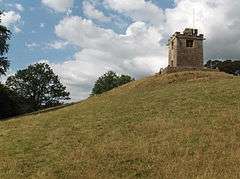 |
| Byre to North of Croglin Low Hall | Kirkoswald, Eden | Barn | Early 16th century | 22 December 1967 | NY5544045033 54°47′53″N 2°41′41″W / 54.798186°N 2.694627°W |
1137444 |
|
| Church of St Oswald | Kirkoswald, Eden | Church | Early 12th century | 27 December 1967 | NY5551440902 54°45′40″N 2°41′34″W / 54.761072°N 2.692841°W |
1327058 |  |
| Croglin Low Hall | Kirkoswald, Eden | Farmhouse | 1984 | 27 December 1967 | NY5543745022 54°47′53″N 2°41′41″W / 54.798087°N 2.694672°W |
1327062 |
|
| Demesne Farmhouse | Kirkoswald, Eden | Farmhouse | 1622 | 27 December 1967 | NY5561241047 54°45′45″N 2°41′29″W / 54.762384°N 2.691341°W |
1144810 |  |
| Nether Haresceugh | Kirkoswald, Eden | Farmhouse | 1612 | 27 December 1967 | NY5770642141 54°46′21″N 2°39′32″W / 54.772396°N 2.658961°W |
1312296 |
|
| Ona Ash | High Bankhill, Kirkoswald, Eden | House | 1693 | 28 June 1983 | NY5602742131 54°46′20″N 2°41′06″W / 54.772161°N 2.685056°W |
1137312 |  |
| Church of St Peter | Langwathby, Eden | Parish Church | 13th century | 3 September 1987 | NY5690433730 54°41′48″N 2°40′13″W / 54.696747°N 2.670177°W |
1145310 |  |
| Strickland Hall and Stables Adjoining | Little Strickland, Eden | Farmhouse | Mid 16th century | 6 February 1968 | NY5636019708 54°34′15″N 2°40′35″W / 54.570697°N 2.676522°W |
1145319 |
|
| Church of St Michael | Lowther, Eden | Parish Church | 12th century | 6 February 1968 | NY5190424454 54°36′47″N 2°44′46″W / 54.612939°N 2.746219°W |
1145328 | 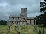 |
| Hackthorpe Hall | Hackthorpe, Lowther, Eden | Farmhouse | Early 17th century | 6 February 1968 | NY5445222838 54°35′55″N 2°42′23″W / 54.598655°N 2.706518°W |
1145324 | 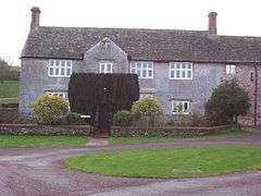 |
| Inner Terrace Wall, Ramps and Steps North of Lowther Castle | Lowther, Eden | Steps | 1806-10 | 3 September 1987 | NY5215323868 54°36′28″N 2°44′32″W / 54.607697°N 2.742268°W |
1343690 |  |
| Lodge North of Lowther Castle | Lowther, Eden | Lodge | 1806-10 | 6 February 1968 | NY5216123937 54°36′30″N 2°44′32″W / 54.608318°N 2.742155°W |
1356111 |
|
| Lowther Castle | Lowther, Eden | Country House | 1806-14 | 6 February 1968 | NY5214823802 54°36′26″N 2°44′32″W / 54.607104°N 2.742334°W |
1068767 | |
| Lowther Cottage | Lowther, Eden | House | 1766-73 | 6 February 1968 | NY5365723586 54°36′19″N 2°43′08″W / 54.605304°N 2.718941°W |
1356573 |
|
| Outer Terrace Wall North of Lowther Castle | Lowther, Eden | Garden Terrace | 1806-10 | 6 February 1968 | NY5221923948 54°36′30″N 2°44′29″W / 54.608422°N 2.741259°W |
1145327 |
|
| Pump and Trough South of Numbers 13-20 | Lowther, Eden | Trough | Late 18th century | 6 February 1968 | NY5362723651 54°36′21″N 2°43′10″W / 54.605885°N 2.719415°W |
1145294 |
|
| Stable Block East of Lowther Castle | Lowther, Eden | Stable | 1806-9 | 6 February 1968 | NY5229823825 54°36′26″N 2°44′24″W / 54.607325°N 2.740016°W |
1145326 |
|
| 1–12 Lowther Village | Lowther, Eden | House | 1776-73 | 6 February 1968 | NY5355723650 54°36′21″N 2°43′14″W / 54.60587°N 2.720499°W |
1145293 |  |
| 23–26 Lowther Village | Lowther Village, Lowther, Eden | Estate Cottage | 1766-73 | 6 February 1968 | NY5362023682 54°36′22″N 2°43′10″W / 54.606163°N 2.719529°W |
1145295 |  |
| 21 and 22 Lowther Village | Lowther Village, Lowther, Eden | Estate Cottage | 1765-73 | 6 February 1968 | NY5360823677 54°36′22″N 2°43′11″W / 54.606117°N 2.719714°W |
1326824 |
|
| 13–20 Lowther Village | Lowther, Eden | House | 1766-1773 | 6 February 1968 | NY5360323646 54°36′21″N 2°43′11″W / 54.605838°N 2.719786°W |
1326823 |  |
| Church of St Martin | Martindale, Eden | Church | Medieval foundations | 6 February 1968 | NY4343818401 54°33′28″N 2°52′34″W / 54.55767°N 2.876119°W |
1326837 |  |
| Lyulph's Tower | Matterdale, Eden | House | c. 1795 | 27 December 1967 | NY4041220196 54°34′24″N 2°55′24″W / 54.573451°N 2.923268°W |
1337015 |  |
| Matterdale Church | Matterdale, Eden | Church | 1573 | 27 December 1967 | NY3944122440 54°35′37″N 2°56′19″W / 54.593499°N 2.938749°W |
1145247 | .jpg) |
| Watermillock House and Adjoining Part of Magnolia Cottage | Watermillock, Matterdale, Eden | House | Late 17th century | 27 December 1967 | NY4459422459 54°35′39″N 2°51′32″W / 54.594262°N 2.859013°W |
1326838 |
|
| Altar Tomb to South East of Chancel of Church of St Laurence | Morland, Eden | Altar Tomb | 15th century | 12 April 1984 | NY5984622553 54°35′48″N 2°37′23″W / 54.596552°N 2.622995°W |
1265986 |
|
| Church of St Kentigern | Mungrisdale, Eden | Parish Church | 1756 | 27 December 1967 | NY3636330440 54°39′54″N 2°59′17″W / 54.665003°N 2.988119°W |
1137800 |  |
| Low Mill Farmhouse and Adjoining Barn/byres | Low Mill, Mungrisdale, Eden | Farmhouse | 1611 | 11 January 1985 | NY3683732442 54°40′59″N 2°58′52″W / 54.683052°N 2.981206°W |
1319016 |
|
| Thwaite Hall | Hutton Roof, Mungrisdale, Eden | House | 1967 | 27 December 1967 | NY3748834998 54°42′22″N 2°58′18″W / 54.706099°N 2.971659°W |
1145616 |
|
| Murton Hall, Adjoining Store and Area Wall to Rear | Murton, Eden | House | 14th century | 12 September 1957 | NY7293421766 54°35′25″N 2°25′13″W / 54.590353°N 2.420361°W |
1312339 |  |
| Newbiggin Hall | Newbiggin, Eden | Tower | 1460s | 6 February 1968 | NY6280228683 54°39′07″N 2°34′41″W / 54.651865°N 2.578027°W |
1265903 |
|
| Memorial to Thomas Lawson and Shelter Against East Wall of Friends Burial Ground (at Ngr Ny 585 215) | Newby, Eden | Shelter | 1691 | 24 June 1987 | NY5852021491 54°35′13″N 2°38′36″W / 54.586902°N 2.643366°W |
1158034 |
|
| Newby Hall and Area Wall to North | , Eden | Apartment | 1968 | 6 February 1968 | NY5902521247 54°35′05″N 2°38′08″W / 54.58475°N 2.635518°W |
1326734 |
|
| Ormside Hall and Adjoining Barns | Great Ormside, Eden | House | Late 17th century | 12 April 1984 | NY7019217594 54°33′10″N 2°27′45″W / 54.552707°N 2.462368°W |
1213776 |  |
| Church of All Saints | Orton, Eden | Parish Church | Late 12th century | 6 February 1968 | NY6221408395 54°28′10″N 2°35′04″W / 54.469506°N 2.584525°W |
1145428 |  |
| Petty Hall | Orton, Eden | House | 1604 | 6 February 1968 | NY6221208130 54°28′02″N 2°35′04″W / 54.467125°N 2.584522°W |
1326736 |
|
| Farm Buildings Attached to Glencoyne | Glenridding, Patterdale, Eden | House | Early 17th century | 12 January 1967 | NY3846618685 54°33′35″N 2°57′11″W / 54.559641°N 2.953048°W |
1245329 |
|
| Tarn House and Stable Adjoining West Return | Ravenstonedale, Eden | House | 1664 | 6 February 1968 | NY7497403396 54°25′31″N 2°23′14″W / 54.425374°N 2.387228°W |
1158397 |
|
| The Lane Cottage with Attached Barn and Stable | Ravenstonedale, Eden | Farmhouse | 1767 | 6 February 1968 | NY6943004178 54°25′56″N 2°28′22″W / 54.432097°N 2.472754°W |
1326761 |
|
| Market Hall | Shap, Eden | Market Hall | c. 1687 | 6 February 1968 | NY5628915150 54°31′47″N 2°40′37″W / 54.529732°N 2.676941°W |
1145382 |  |
| Garden Gate, Piers and Wall Immediately North of Eighteenth Century Wing of High Head Castle | High Head, Skelton, Eden | Gate | 1744-7 | 27 December 1967 | NY4028043369 54°46′54″N 2°55′48″W / 54.781655°N 2.930058°W |
1145452 |
|
| High Head Castle, Eighteenth Century Wing | High Head, Skelton, Eden | Castle | Medieval | 24 October 1986 | NY4027943334 54°46′53″N 2°55′48″W / 54.781341°N 2.930066°W |
1145451 | 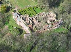 |
| Tudor Wing West of High Head Castle | High Head, Skelton, Eden | Castle | Mid 16th century | 24 October 1986 | NY4026543332 54°46′53″N 2°55′49″W / 54.781321°N 2.930283°W |
1145453 |
|
| Thrimby Hall | Thrimby, Eden | Farmhouse | 1673 | 6 February 1968 | NY5556420464 54°34′39″N 2°41′20″W / 54.577421°N 2.688947°W |
1076978 |
|
| Smardale Hall and Adjoining Buildings | Waitby, Eden | House | C19/C20 | 6 February 1968 | NY7392008096 54°28′03″N 2°24′14″W / 54.467558°N 2.403888°W |
1326959 |  |
| Warcop Hall | Warcop, Eden | House | Late 16th century | 12 September 1957 | NY7471915728 54°32′10″N 2°23′32″W / 54.536185°N 2.392218°W |
1137455 |
|
| Warcop Old Bridge over River Eden to South-west of Eden Gate | Warcop, Eden | Road Bridge | 16th century | 12 September 1957 | NY7432215095 54°31′50″N 2°23′54″W / 54.530476°N 2.398298°W |
1144870 |
|
| Manor House | Winton, Eden | House | 1726 | 12 September 1957 | NY7841110607 54°29′25″N 2°20′05″W / 54.490336°N 2.334784°W |
1144873 |
|
| Mansion House | Eamont Bridge, Yanwath and Eamont Bridge, Eden | House | 1686 | 6 February 1968 | NY5231228584 54°39′00″N 2°44′26″W / 54.65009°N 2.740576°W |
1326789 |
|
| 2 Gate Piers to the Forecourt of the Mansion House | Eden | Gate Pier | 18th century | 24 April 1951 | NY5176830169 54°39′51″N 2°44′57″W / 54.664281°N 2.749268°W |
1145110 |
|
| Abbots Bank | Eden | House | 1820 | 24 April 1951 | NY5181230165 54°39′51″N 2°44′55″W / 54.664249°N 2.748585°W |
1145097 |
|
| Carleton Hall (Cumbria Police Headquarters) | Carleton, Eden | House | Early 18th century | 24 April 1951 | NY5254829208 54°39′21″N 2°44′13″W / 54.65572°N 2.73702°W |
1312133 |  |
| Carleton Hall Farmhouse | Eden | Farmhouse | Early 18th century | 24 April 1951 | NY5286429525 54°39′31″N 2°43′56″W / 54.658598°N 2.732174°W |
1326892 |
|
| Cockell House | Eden | House | 1660 | 24 April 1951 | NY5116630774 54°40′11″N 2°45′31″W / 54.669659°N 2.758702°W |
1326920 |
|
| Corney House | Eden | House | 1777 | 24 April 1951 | NY5148430391 54°39′58″N 2°45′13″W / 54.666249°N 2.753708°W |
1312134 |
|
| Hutton Hall | Penrith, Eden | House | 17th century | 9 February 1983 | NY5180630250 54°39′54″N 2°44′55″W / 54.665012°N 2.748693°W |
1326922 |
|
| Lowther Gardens | Eden | House | 18th century | 24 April 1951 | NY5154630146 54°39′51″N 2°45′10″W / 54.664053°N 2.752706°W |
1137877 |
|
| Malthouse in Grounds of Shepherd's Hill | Eden | Malt House | 18th century | 9 February 1983 | NY5122430492 54°40′02″N 2°45′28″W / 54.667131°N 2.757755°W |
1145062 |
|
| Mansion House | Eden | Mansion House | 1750 | 24 April 1951 | NY5173330219 54°39′53″N 2°44′59″W / 54.664727°N 2.749819°W |
1145109 |
|
| Masonic Hall | Eden | Freemasons Hall | Early 18th century | 24 April 1951 | NY5179430236 54°39′54″N 2°44′56″W / 54.664886°N 2.748876°W |
1312059 |
|
| North Friarage | Eden | House | 1717 | 24 April 1951 | NY5180030127 54°39′50″N 2°44′56″W / 54.663907°N 2.748765°W |
1145096 |
|
| Plague Stone in Grounds of Greengarth Old People's Home | Eden | Cross | Earlier | 24 April 1951 | NY5196329563 54°39′32″N 2°44′46″W / 54.658854°N 2.746146°W |
1137825 |
|
| Shepherd's Hill | Eden | House | Late 18th century | 24 April 1951 | NY5124130506 54°40′02″N 2°45′27″W / 54.667258°N 2.757494°W |
1311922 |
|
| The George Hotel | Eden | House | Early 18th century | 24 April 1951 | NY5157230174 54°39′52″N 2°45′08″W / 54.664307°N 2.752307°W |
1145087 |
|
| Tourist Information Centre | Eden | School | Elizabethan | 24 April 1951 | NY5145530334 54°39′57″N 2°45′15″W / 54.665734°N 2.754148°W |
1311984 |
|
| Tudor Restaurant | Eden | House | 16th century | 24 April 1951 | NY5161730119 54°39′50″N 2°45′06″W / 54.663817°N 2.751601°W |
1145054 |
|
| Two Lions Public House and Integral Stables | Eden | Public House | 17th century | 24 April 1951 | NY5157029970 54°39′45″N 2°45′08″W / 54.662474°N 2.752304°W |
1312062 |
|
| 1 St Andrew's Place | Eden | House | c. 1750 | 24 April 1951 | NY5166030115 54°39′50″N 2°45′03″W / 54.663785°N 2.750933°W |
1138160 |
|
| 17 and 18 Devonshire Street | Eden | House | 18th century | 9 February 1983 | NY5154130203 54°39′52″N 2°45′10″W / 54.664565°N 2.752793°W |
1145086 |
|
| 13, 14 and 15 Sandgate | Eden | House | Earlier | 24 April 1951 | NY5170430348 54°39′57″N 2°45′01″W / 54.665883°N 2.75029°W |
1145056 |
|
| 4 Angel Lane | Eden | House | Earlier | 24 April 1951 | NY5156230074 54°39′48″N 2°45′09″W / 54.663408°N 2.752446°W |
1326903 |
|
| 1, 2 and 3 Bishop Yards | Eden | House | 18th century | 24 April 1951 | NY5173330143 54°39′51″N 2°44′59″W / 54.664044°N 2.749806°W |
1326890 | |
Notes
- ↑ The date given is the date used by Historic England as significant for the initial building or that of an important part in the structure's description.
- ↑ Sometimes known as OSGB36, the grid reference is based on the British national grid reference system used by the Ordnance Survey.
- ↑ The "List Entry Number" is a unique number assigned to each listed building and scheduled monument by Historic England.
External links
![]() Media related to Grade II* listed buildings in Cumbria at Wikimedia Commons
Media related to Grade II* listed buildings in Cumbria at Wikimedia Commons
This article is issued from Wikipedia - version of the 11/6/2016. The text is available under the Creative Commons Attribution/Share Alike but additional terms may apply for the media files.