High Head Castle

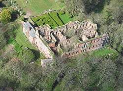
High Head Castle is a large fortified manor house in the English county of Cumbria. It is located between Carlisle and Penrith. The house is now little more than a ruin with just the mere exterior walls and certain foundations surviving. It is currently privately owned, and the owners have now for some time been trying to restore it to its former glory.
The site was originally occupied by the Kings Castle in the Forest of Inglewood. The earliest written record is of the original castle is from 1272. This castle was a medieval square pele tower within a curtain wall.
The first known occupants of the house were the Richmond family who bought and extended the house in the 16th century. Only its western wing remains, with its unmistakable straight headed mullioned windows with round-arched lights under hood moulds, although attached to the south-west corner of this wing is the basement of a square tower which presents evidence of 14th century work.
The house was later sold to the Baron Brougham and Vaux who made some alterations. One member of the family, Henry Richmond Brougham, had a new facade built in 1744-8. It is eleven bays long, with a pedimented three-bay centre, and a walled front garden with coupled Ionic columns. When the Broughams no longer required the house they rented it out for some time. By the mid-19th century and until at least 1909 it was occupied by the Hills family, and the childhood home of the soldier and astronomer Edmond Hills. The only other people known to have rented it were the Cavaghan family (co-founders of Cavaghan & Gray) who lived in the house for around three years during the thirties.
The castle was largely destroyed by fire in 1956, and is now little more than a shell. Both the medieval wing and the principal house are Grade 2 listed. Adjacent is a fine stable quadrangle with heavy rustication, a steep pediment gable and cupola.
See also
External links
| Wikimedia Commons has media related to High Heat Castle. |
Coordinates: 54°46′53″N 2°55′48″W / 54.7813°N 2.9300°W