Gouldsboro, Pennsylvania
| Gouldsboro, Pennsylvania | |
|---|---|
|
Village Census-designated place | |
| Village of Gouldsboro | |
|
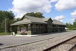
The former Lackawanna Railroad's Gouldsboro Station in Gouldsboro, which has recently been restored. | |
| Nickname(s): Gouldsboro'[1] | |
 Location in Wayne County and the state of Pennsylvania. | |
| Country | United States |
| Commonwealth | Pennsylvania |
| U.S. Congressional Districts |
PA-10 PA-17 |
| School Districts |
North Pocono (Region III) Pocono Mountain (Region III) |
| Counties |
Wayne Monroe |
| Magisterial Districts |
22-3-01[2] 43-3-01[3] |
| Townships |
Lehigh Coolbaugh |
| Settled | 1871 |
| Named for | Jay Gould |
| Area | |
| • Total | 3.004 sq mi (7.783 km2) |
| • Land | 2.596[4] sq mi (6.723 km2) |
| • Water | 0.408[4] sq mi (1.06 km2) |
| Elevation | 1,909[5] ft (582 m) |
| Population (2010) | |
| • Total | 890[6] |
| • Density | 343/sq mi (132/km2) |
| Time zone | Eastern (EST) (UTC-5) |
| • Summer (DST) | Eastern Daylight (EDT) (UTC-4) |
| ZIP code | 18424[7] |
| Area code(s) | 570 |
| GNIS feature IDs |
1175862[5] (Village) 2631315[8] (CDP) |
| FIPS codes |
42-127-42432[9]-30200[5] 42-089-15960[10]-30200[5] |
| Major Roads |
|
| Waterways | Gouldsboro Lake, Larsen Lake,[11] Lake Lehigh,[12] Lehigh River, Lower Klondike Pond,[13] Snag Pond,[14] Lake Watawga,[15] Westend Pond[16] |
Gouldsboro is a village and census-designated place (CDP) in Lehigh Township, Wayne County, and Coolbaugh Township, Monroe County, in Pennsylvania. The CDP's population was 890 at time of the 2010 United States Census.
History

Gouldsboro was named for Jay Gould, one of the 10 richest Americans of all time.[17]
Geography
According to the United States Census Bureau, Gouldsboro has a total area of 3.004 sq mi (7.783 km2), of which 2.596 sq mi (6.723 km2) is land and 0.408 sq mi (1.06 km2), or 5.72%, is water.[4]
Demographics
As of the Census of 2010, there were 890 people, 353 households, and 253 families in Gouldsboro. The CDP's population density was 343 people per square mile (131/km2), and there were 546 housing units at an average density of 182/sq mi (70.2/km2). The racial makeup of the populace was 94.9% White, 1.0% African American, 0.1% Native American, 1.3% Asian, 0.1% Pacific Islander, 1.3% of other races, and 1.1% of two or more races. Hispanics and Latinos of all races made up 4.0% of the population.[4][18]
71.7% of Gouldsboro's households were families, 55.8% were headed by a heterosexual married couple (Pennsylvania did not allow same-sex marriage until May 20, 2014, after the 2010 Census had been completed), and 30.3% included children under the age of 18. 10.8% of households were headed by a female householder with no husband present, 5.1% by a male householder with no wife present, and 28.3% consisted of non-families. 24.1% of all households were made up of individuals, and 13.3% consisted of a person 65 years of age or older living alone. The average household size was 2.52 and the average family size was 2.95.[18]
Gouldsboro's age distribution was 23.9% under the age of 18, 5.2% between the ages of 18 and 24, 19.9% between 25 and 44, 34.7% between 45 and 64, and 16.3% 65 years of age or older. The population's median age was 45.4 years. For every 100 females, there were 98.7 males. For every 100 females age 18 and over, there were 99.7 males in the same age range.[18]
According to American Community Survey (ACS) estimates, the median income for a household in Gouldsboro in 2013 was $45,469, and the median income for a family was $54,000. Males had a median income of $50,000, while females had a median income of $28,750. The per capita income for the CDP was $27,753. 0.0% of families and 1.4% of people were below the Census Bureau's poverty thresholds (different from the federally defined poverty guidelines), including 0.0% of those under age 18 and 4.7% of those age 65 or over.[19][20]
According to self-reported ancestry figures recorded by the ACS, the five largest ancestral groups in Gouldsboro in 2013 were Irish (40.3%), Germans (38.0%), Poles (13.9%), English (13.4%), and Italians (13.3%). Those reporting American ancestry made up 2.5% of the population.[21]
Parks and recreation
Gouldsboro is home to the Gouldsboro State Park.[17] The village is serviced and is within the North Pocono School District.
The area is extremely scenic and popular with hunters and naturalists. Much of Wayne County's water is under special protection.[22]
Education
The majority of Gouldsboro is in Lehigh Township, and is therefore served primarily by the North Pocono School District, in which it is part of Region III. The small part of the CDP which is contained within Coolbaugh Township, however, is in the Pocono Mountain School District, in which it is also part of Region III.
Postal Service
In addition to parts of the aforementioned Lehigh and Coolbaugh Townships, parts of Clifton, Thornhurst, and Covington Townships in Lackawanna County are serviced by the Gouldsboro Post Office, and are also often referred to as "Gouldsboro."
References
- ↑ White, Israel Charles; Dolph, John M. (1881). The Geology of Susquehanna County and Wayne County (Report). 23. Board of Commissioners for the Second Geological Survey of Pennsylvania. p. 12. Retrieved 1 June 2015.
- ↑ "District Magistrate". Wayne County, PA. Wayne County Courthouse. 2015. Retrieved 1 June 2015.
- ↑ "Magisterial District Judges". Monroe County, Pennsylvania. Monroe County, Pennsylvania. 2005. Retrieved 1 June 2015.
- 1 2 3 4 2014 Census National Places Gazetteer File for Pennsylvania (Report). U.S. Department of Commerce. 2014. Retrieved 29 June 2015.
- 1 2 3 4 "Gouldsboro". Geographic Names Information System. United States Geological Survey. 2 August 1979. Retrieved 1 June 2015.
- ↑ "2010 Census Interactive Population Search". Census.gov. U.S. Department of Commerce. 2010. Retrieved 1 June 2015.
- ↑ "Look up a ZIP CodeTM". USPS.COM. USPS. 2015. Retrieved 1 June 2015.
- ↑ "Gouldsboro Census Designated Place". Geographic Names Information System. United States Geological Survey. 30 August 2010. Retrieved 1 June 2015.
- ↑ U.S. Census Bureau. Census 2000. "Census Demographic Profiles, Lehigh Township" (PDF). CenStats Databases. Retrieved 1 June 2015.
- ↑ U.S. Census Bureau. Census 2000. "Census Demographic Profiles, Coolbaugh Township" (PDF). CenStats Databases. Retrieved 1 June 2015.
- ↑ "Larsen Lake". Geographic Names Information System. United States Geological Survey. 30 August 1990. Retrieved 1 June 2015.
- ↑ "Lake Lehigh". Geographic Names Information System. United States Geological Survey. 30 August 1990. Retrieved 1 June 2015.
- ↑ "Lower Klondike Pond". Geographic Names Information System. United States Geological Survey. 2 August 1979. Retrieved 1 June 2015.
- ↑ "Snag Pond". Geographic Names Information System. United States Geological Survey. 2 August 1979. Retrieved 1 June 2015.
- ↑ "Lake Watawga". Geographic Names Information System. United States Geological Survey. 2 August 1979. Retrieved 1 June 2015.
- ↑ "Westend Pond". Geographic Names Information System. United States Geological Survey. 2 August 1979. Retrieved 1 June 2015.
- 1 2 "Gouldsboro State Park". Pennsylvania Department of Conservation and Natural Resources. Commonwealth of Pennsylvania. 2009. Retrieved 5 June 2015.
- 1 2 3 Profile of General Population and Housing Characteristics: 2010 Demographic Profile Data for Gouldsboro, Pennsylvania (Report). U.S. Department of Commerce. 2010. Retrieved 5 June 2015.
- ↑ Selected Economic Characteristics 2009–2013 American Community Survey 5-Year Estimates for Gouldsboro, Pennsylvania (Report). U.S. Department of Commerce. 2013. Retrieved 5 June 2015.
- ↑ Occupation by Sex and Median Earnings in the Past 12 Months (In 2013 Inflation-Adjusted Dollars) For the Civilian Employed Population 16 Years and Over 2009–2013 American Community Survey 5-Year Estimates for Gouldsboro, Pennsylvania (Report). U.S. Department of Commerce. 2013. Retrieved 5 June 2015.
- ↑ Selected Social Characteristics in the United States 2009–2013 American Community Survey 5-Year Estimates for Gouldsboro, Pennsylvania (Report). U.S. Department of Commerce. 2013. Retrieved 29 June 2015.
- ↑ "Special Protection Waters". Wayne County Planning Commission / GIS. Wayne County Courthouse. Retrieved 5 June 2015.
Municipalities and communities of Wayne County, Pennsylvania, United States | ||
|---|---|---|
| Boroughs |  | |
| Townships | ||
| CDPs | ||
| Unincorporated communities | ||
Municipalities and communities of Monroe County, Pennsylvania, United States | ||
|---|---|---|
| Boroughs |  | |
| Townships | ||
| CDPs | ||
| Unincorporated communities |
| |
| Footnotes | ‡This populated place also has portions in an adjacent county | |