Gladstone Township, Henderson County, Illinois
| Gladstone Township | |
|---|---|
| Township | |
|
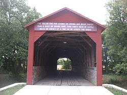
The Oquawka Wagon Bridge, a covered bridge in the township's far north | |
 Location in Henderson County | |
 Henderson County's location in Illinois | |
| Coordinates: 40°50′41″N 90°58′39″W / 40.84472°N 90.97750°WCoordinates: 40°50′41″N 90°58′39″W / 40.84472°N 90.97750°W | |
| Country |
|
| State |
|
| County | Henderson |
| Established | November 6, 1906 |
| Area | |
| • Total | 49.14 sq mi (127.3 km2) |
| • Land | 46.84 sq mi (121.3 km2) |
| • Water | 2.3 sq mi (6 km2) 4.68% |
| Elevation | 548 ft (167 m) |
| Population (2010) | |
| • Total | 962 |
| • Density | 20.5/sq mi (7.9/km2) |
| Time zone | CST (UTC-6) |
| • Summer (DST) | CDT (UTC-5) |
| ZIP codes | 61418, 61425, 61437, 61469 |
| GNIS feature ID | 0429055 |
Gladstone Township is one of eleven townships in Henderson County, Illinois, USA. As of the 2010 census, its population was 962 and it contained 536 housing units.[1]
Geography
According to the 2010 census, the township has a total area of 49.14 square miles (127.3 km2), of which 46.84 square miles (121.3 km2) (or 95.32%) is land and 2.3 square miles (6.0 km2) (or 4.68%) is water.[1]
Cities, towns, villages
Unincorporated towns
(This list is based on USGS data and may include former settlements.)
Cemeteries
The township contains these two cemeteries: Kemp and South Henderson.
Major highways
Lakes
- Crystal Lake
- Dutton Lake
- Gladstone Lake
- Pogue Lake
- Stony Point Lake
Landmarks
- Lock and Dam No. 18
- Oquawka State Wildlife Refuge
School districts
- West Central Community Unit School District 235
Political districts
- Illinois's 17th congressional district
- State House District 94
- State Senate District 47
References
- United States Census Bureau 2008 TIGER/Line Shapefiles
- "Gladstone Township". Geographic Names Information System. United States Geological Survey. Retrieved 2009-09-19.
- United States National Atlas
- 1 2 "Population, Housing Units, Area, and Density: 2010 - County -- County Subdivision and Place -- 2010 Census Summary File 1". United States Census. Retrieved 2013-05-28.
External links
 |
|
Oquawka Township Rozetta Township |
| |
| Tama Township, Des Moines County, Iowa | |
Biggsville Township | ||
| ||||
| | ||||
| Carman Township | Stronghurst Township | Media Township |
Municipalities and communities of Henderson County, Illinois, United States | ||
|---|---|---|
| City | ||
| Villages | ||
| Townships | ||
| Unincorporated communities |
| |
| Footnotes | ‡This populated place also has portions in an adjacent county or counties | |
This article is issued from Wikipedia - version of the 12/24/2013. The text is available under the Creative Commons Attribution/Share Alike but additional terms may apply for the media files.