Georgetown, Ohio
| Georgetown, Ohio | |
|---|---|
| Village | |
|
| |
 Location of Georgetown, Ohio | |
 Location of Georgetown in Brown County | |
| Coordinates: 38°52′1″N 83°54′9″W / 38.86694°N 83.90250°WCoordinates: 38°52′1″N 83°54′9″W / 38.86694°N 83.90250°W | |
| Country | United States |
| State | Ohio |
| County | Brown |
| Township | Pleasant |
| Government | |
| • Mayor | Dale Cahall |
| Area[1] | |
| • Total | 4.04 sq mi (10.46 km2) |
| • Land | 4.04 sq mi (10.46 km2) |
| • Water | 0 sq mi (0 km2) |
| Elevation[2] | 919 ft (280 m) |
| Population (2010)[3] | |
| • Total | 4,331 |
| • Estimate (2012[4]) | 4,466 |
| • Density | 1,072.0/sq mi (413.9/km2) |
| Time zone | Eastern (EST) (UTC-5) |
| • Summer (DST) | EDT (UTC-4) |
| ZIP code | 45121 |
| Area code(s) | 937 |
| FIPS code | 39-29778[5] |
| GNIS feature ID | 1064714[2] |
| Website | http://www.georgetownohio.us/ |
Georgetown is a village in Brown County, Ohio, United States. The population was 4,331 at the 2010 census. It is the county seat of Brown County.[6] Georgetown was the childhood home of Ulysses S. Grant.
History
Georgetown was platted in 1819.[7][8] The village took its name from Georgetown, Kentucky.[9] A post office called Georgetown has been in operation since 1821.[10]
Geography
Georgetown is located at 38°52′1″N 83°54′9″W / 38.86694°N 83.90250°W (38.866926, -83.902590).[11]
According to the United States Census Bureau, the village has a total area of 4.04 square miles (10.46 km2), all land.[1]
Gallery
 Georgetown's north side from the air.
 Georgetown corporation limit sign.
 Looking north on Main Street in Georgetown.
Demographics
| Historical population | |||
|---|---|---|---|
| Census | Pop. | %± | |
| 1850 | 618 | — | |
| 1860 | 723 | 17.0% | |
| 1870 | 1,037 | 43.4% | |
| 1880 | 1,293 | 24.7% | |
| 1890 | 1,473 | 13.9% | |
| 1900 | 1,529 | 3.8% | |
| 1910 | 1,580 | 3.3% | |
| 1920 | 1,670 | 5.7% | |
| 1930 | 1,531 | −8.3% | |
| 1940 | 1,848 | 20.7% | |
| 1950 | 2,200 | 19.0% | |
| 1960 | 2,674 | 21.5% | |
| 1970 | 3,087 | 15.4% | |
| 1980 | 3,467 | 12.3% | |
| 1990 | 3,627 | 4.6% | |
| 2000 | 3,631 | 0.1% | |
| 2010 | 4,331 | 19.3% | |
| Est. 2015 | 4,447 | [12] | 2.7% |
2010 census
As of the census[3] of 2010, there were 4,331 people, 1,722 households, and 1,085 families residing in the village. The population density was 1,072.0 inhabitants per square mile (413.9/km2). There were 1,939 housing units at an average density of 480.0 per square mile (185.3/km2). The racial makeup of the village was 95.5% White, 1.9% African American, 0.3% Native American, 0.5% Asian, 0.2% from other races, and 1.6% from two or more races. Hispanic or Latino of any race were 0.6% of the population.
There were 1,722 households of which 34.6% had children under the age of 18 living with them, 41.6% were married couples living together, 15.7% had a female householder with no husband present, 5.7% had a male householder with no wife present, and 37.0% were non-families. 32.7% of all households were made up of individuals and 14.8% had someone living alone who was 65 years of age or older. The average household size was 2.36 and the average family size was 2.93.
The median age in the village was 38.6 years. 24.5% of residents were under the age of 18; 7.9% were between the ages of 18 and 24; 25.5% were from 25 to 44; 23.2% were from 45 to 64; and 18.7% were 65 years of age or older. The gender makeup of the village was 48.2% male and 51.8% female.
2000 census
As of the census[5] of 2000, there were 3,691 people, 1,565 households, and 996 families residing in the village. The population density was 997.1 people per square mile (385.2/km²). There were 1,702 housing units at an average density of 459.8 per square mile (177.6/km²). The racial makeup of the village was 96.75% White, 2.00% African American, 0.11% Native American, 0.30% Asian, 0.11% from other races, and 0.73% from two or more races. Hispanic or Latino of any race were 0.43% of the population.
There were 1,565 households out of which 33.4% had children under the age of 18 living with them, 43.1% were married couples living together, 15.5% had a female householder with no husband present, and 36.3% were non-families. 32.7% of all households were made up of individuals and 15.4% had someone living alone who was 65 years of age or older. The average household size was 2.30 and the average family size was 2.89.
In the village the population was spread out with 25.3% under the age of 18, 9.4% from 18 to 24, 27.7% from 25 to 44, 21.7% from 45 to 64, and 15.8% who were 65 years of age or older. The median age was 36 years. For every 100 females there were 83.6 males. For every 100 females age 18 and over, there were 80.1 males.
The median income for a household in the village was $29,807, and the median income for a family was $37,371. Males had a median income of $31,897 versus $19,634 for females. The per capita income for the village was $18,112. About 11.7% of families and 14.5% of the population were below the poverty line, including 18.2% of those under age 18 and 17.0% of those age 65 or over.
Places of interest
President Ulysses S. Grant grew up and attended grade school in Georgetown. The school house is still in the town, where the locals refer to it as the Grant Schoolhouse. Also in Georgetown are Grant's childhood home and the tannery that his father owned across the street. All three are stops on the Land of Grant tour.
Being the county seat, Georgetown hosts the large Brown County Fair and parade which brings in thousands of patrons from other towns. The headstone of General Thomas L. Hamer is in the old cemetery located by the Brown County Fair Grounds.
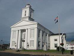
Seventeen acres of the city was listed on the National Register of Historic Places in 1978 as the Georgetown Historic District.[14]
Notable people
- Electra Collins Doren - suffragette, library scientist
- Brian Grant - former professional basketball player
- Ulysses S. Grant - former President of the United States
- Thomas L. Hamer - U.S. Congressman who fought in the Mexican-American War
- Albert Kautz - U.S. Navy Rear Admiral
- Rodney J. McKinley - Chief Master Sergeant of the Air Force
- John Ruthven - wildlife artist
References
- 1 2 "US Gazetteer files 2010". United States Census Bureau. Retrieved 2013-01-06.
- 1 2 "US Board on Geographic Names". United States Geological Survey. 2007-10-25. Retrieved 2008-01-31.
- 1 2 "American FactFinder". United States Census Bureau. Retrieved 2013-01-06.
- ↑ "Population Estimates". United States Census Bureau. Retrieved 2013-06-17.
- 1 2 "American FactFinder". United States Census Bureau. Retrieved 2008-01-31.
- ↑ "Find a County". National Association of Counties. Retrieved 2011-06-07.
- ↑ The History of Brown County, Ohio: Containing a History of the County, Its Townships, Towns, Churches, Schools, Etc. Higginson Book Company. 1883. p. 385.
- ↑ Karle, Tina. "120 Waterfall Hikes Around Cincinnati Ohio". Lulu.com. p. 13. Retrieved 27 November 2013.
- ↑ Overman, William Daniel (1958). Ohio Town Names. Akron, OH: Atlantic Press. p. 50.
- ↑ "Post offices". Jim Forte Postal History. Retrieved 11 June 2016.
- ↑ "US Gazetteer files: 2010, 2000, and 1990". United States Census Bureau. 2011-02-12. Retrieved 2011-04-23.
- ↑ "Annual Estimates of the Resident Population for Incorporated Places: April 1, 2010 to July 1, 2015". Retrieved July 2, 2016.
- ↑ "Census of Population and Housing". Census.gov. Retrieved June 4, 2015.
- ↑ National Park Service (2009-03-13). "National Register Information System". National Register of Historic Places. National Park Service.
External links
Municipalities and communities of Brown County, Ohio, United States | ||
|---|---|---|
| Villages |  | |
| Townships | ||
| CDPs | ||
| Unincorporated communities | ||
| Footnotes | ‡This populated place also has portions in an adjacent county or counties | |