Lake Lorelei, Ohio
| Lake Lorelei, Ohio | |
|---|---|
| Census-designated place | |
 Lake Lorelei | |
| Coordinates: 39°11′19″N 83°58′1″W / 39.18861°N 83.96694°WCoordinates: 39°11′19″N 83°58′1″W / 39.18861°N 83.96694°W | |
| Country | United States |
| State | Ohio |
| County | Brown |
| Area[1] | |
| • Total | 2.45 sq mi (6.35 km2) |
| • Land | 2.20 sq mi (5.70 km2) |
| • Water | 0.25 sq mi (0.65 km2) |
| Elevation[2] | 925 ft (282 m) |
| Population (2010)[1] | |
| • Total | 1,170 |
| • Density | 531/sq mi (205.2/km2) |
| Time zone | Eastern (EST) (UTC-5) |
| • Summer (DST) | EDT (UTC-4) |
| Area code(s) | 513 |
| FIPS code | 39-41419[3] |
| GNIS feature ID | 2628918[2] |
Lake Lorelei is a gated community and census-designated place in Brown County, Ohio, United States, near the village of Fayetteville.[4][5] As of the 2010 census, it had a population of 1,170.[1]
History
Lake Lorelei was started in the late 1960s by property developers as a lakeside planned community.[6]
Geography
Lake Lorelei is located in northern Brown County, in the western part of Perry Township. It consists of a housing development built around Lake Lorelei, a reservoir on Glady Run, a tributary of the Little Miami River.
State Route 131 forms the southern border of the CDP, and U.S. Route 50 touches the community's southeast corner. Lake Lorelei is 3 miles (5 km) west of the village of Fayetteville and 34 miles (55 km) east of downtown Cincinnati.
References
- 1 2 3 "Geographic Identifiers: 2010 Demographic Profile Data (G001): Lake Lorelei CDP, Ohio". U.S. Census Bureau, American Factfinder. Retrieved February 21, 2014.
- 1 2 "US Board on Geographic Names". United States Geological Survey. 2007-10-25. Retrieved 2008-01-31.
- ↑ "American FactFinder". United States Census Bureau. Retrieved 2008-01-31.
- ↑ "Lake Lorelei". Lake Lorelei. Retrieved 2009-06-20.
- ↑ U.S. Geological Survey Geographic Names Information System: Lake Lorelei, Ohio
- ↑ "About Lake Lorelei". LLPOA. Retrieved 21 December 2015.
External links
Municipalities and communities of Brown County, Ohio, United States | ||
|---|---|---|
| Villages | 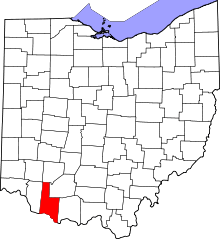 | |
| Townships | ||
| CDPs | ||
| Unincorporated communities | ||
| Footnotes | ‡This populated place also has portions in an adjacent county or counties | |
This article is issued from Wikipedia - version of the 11/26/2016. The text is available under the Creative Commons Attribution/Share Alike but additional terms may apply for the media files.