Gehée
| Gehée | ||
|---|---|---|
|
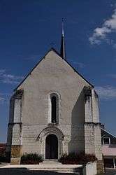
The church of Saint-Etienne, in Géhée | ||
| ||
 Gehée | ||
|
Location within Centre-Val de Loire region  Gehée | ||
| Coordinates: 47°02′51″N 1°30′10″E / 47.0475°N 1.5028°ECoordinates: 47°02′51″N 1°30′10″E / 47.0475°N 1.5028°E | ||
| Country | France | |
| Region | Centre-Val de Loire | |
| Department | Indre | |
| Arrondissement | Châteauroux | |
| Canton | Écueillé | |
| Intercommunality | Pays d'Écueillé | |
| Government | ||
| • Mayor (2008–2014) | Alain Reuillon | |
| Area1 | 22.75 km2 (8.78 sq mi) | |
| Population (2009)2 | 282 | |
| • Density | 12/km2 (32/sq mi) | |
| Time zone | CET (UTC+1) | |
| • Summer (DST) | CEST (UTC+2) | |
| INSEE/Postal code | 36082 / 36240 | |
| Elevation |
112–178 m (367–584 ft) (avg. 200 m or 660 ft) | |
|
1 French Land Register data, which excludes lakes, ponds, glaciers > 1 km² (0.386 sq mi or 247 acres) and river estuaries. 2 Population without double counting: residents of multiple communes (e.g., students and military personnel) only counted once. | ||

Gehée is a commune in the Indre department in central France.
Population
| Historical population | ||
|---|---|---|
| Year | Pop. | ±% |
| 1793 | 534 | — |
| 1800 | 518 | −3.0% |
| 1806 | 523 | +1.0% |
| 1821 | 844 | +61.4% |
| 1831 | 884 | +4.7% |
| 1836 | 903 | +2.1% |
| 1841 | 846 | −6.3% |
| 1846 | 882 | +4.3% |
| 1851 | 886 | +0.5% |
| 1856 | 874 | −1.4% |
| 1861 | 860 | −1.6% |
| 1866 | 953 | +10.8% |
| 1872 | 899 | −5.7% |
| 1876 | 876 | −2.6% |
| 1881 | 901 | +2.9% |
| 1886 | 867 | −3.8% |
| 1891 | 881 | +1.6% |
| 1896 | 834 | −5.3% |
| 1901 | 807 | −3.2% |
| 1906 | 760 | −5.8% |
| 1911 | 781 | +2.8% |
| 1921 | 705 | −9.7% |
| 1926 | 732 | +3.8% |
| 1931 | 670 | −8.5% |
| 1936 | 648 | −3.3% |
| 1946 | 605 | −6.6% |
| 1954 | 580 | −4.1% |
| 1962 | 553 | −4.7% |
| 1968 | 480 | −13.2% |
| 1975 | 439 | −8.5% |
| 1982 | 352 | −19.8% |
| 1990 | 313 | −11.1% |
| 1999 | 301 | −3.8% |
| 2009 | 282 | −6.3% |
See also
References
| Wikimedia Commons has media related to Gehée. |
This article is issued from Wikipedia - version of the 7/20/2016. The text is available under the Creative Commons Attribution/Share Alike but additional terms may apply for the media files.