Vouillon
| Vouillon | |
|---|---|
|
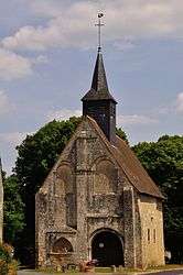
The church of Saint-Saturnin, in Vouillon | |
 Vouillon | |
|
Location within Centre-Val de Loire region  Vouillon | |
| Coordinates: 46°49′21″N 1°55′32″E / 46.8225°N 1.9256°ECoordinates: 46°49′21″N 1°55′32″E / 46.8225°N 1.9256°E | |
| Country | France |
| Region | Centre-Val de Loire |
| Department | Indre |
| Arrondissement | Issoudun |
| Canton | Issoudun-Sud |
| Intercommunality | Champagne berrichonne |
| Government | |
| • Mayor (2008–2014) | Yves Prévot |
| Area1 | 14.98 km2 (5.78 sq mi) |
| Population (2009)2 | 260 |
| • Density | 17/km2 (45/sq mi) |
| Time zone | CET (UTC+1) |
| • Summer (DST) | CEST (UTC+2) |
| INSEE/Postal code | 36248 / 36100 |
| Elevation |
142–171 m (466–561 ft) (avg. 160 m or 520 ft) |
|
1 French Land Register data, which excludes lakes, ponds, glaciers > 1 km² (0.386 sq mi or 247 acres) and river estuaries. 2 Population without double counting: residents of multiple communes (e.g., students and military personnel) only counted once. | |
Vouillon is a commune in the Indre department in central France.
Population
| Historical population | ||
|---|---|---|
| Year | Pop. | ±% |
| 1793 | 420 | — |
| 1800 | 394 | −6.2% |
| 1806 | 397 | +0.8% |
| 1821 | 454 | +14.4% |
| 1831 | 500 | +10.1% |
| 1836 | 506 | +1.2% |
| 1841 | 466 | −7.9% |
| 1846 | 478 | +2.6% |
| 1851 | 523 | +9.4% |
| 1856 | 531 | +1.5% |
| 1861 | 525 | −1.1% |
| 1866 | 521 | −0.8% |
| 1872 | 477 | −8.4% |
| 1876 | 443 | −7.1% |
| 1881 | 464 | +4.7% |
| 1886 | 448 | −3.4% |
| 1891 | 460 | +2.7% |
| 1896 | 407 | −11.5% |
| 1901 | 412 | +1.2% |
| 1906 | 403 | −2.2% |
| 1911 | 373 | −7.4% |
| 1921 | 366 | −1.9% |
| 1926 | 355 | −3.0% |
| 1931 | 373 | +5.1% |
| 1936 | 338 | −9.4% |
| 1946 | 333 | −1.5% |
| 1954 | 307 | −7.8% |
| 1962 | 278 | −9.4% |
| 1968 | 257 | −7.6% |
| 1975 | 228 | −11.3% |
| 1982 | 236 | +3.5% |
| 1990 | 289 | +22.5% |
| 1999 | 250 | −13.5% |
| 2006 | 261 | +4.4% |
| 2009 | 260 | −0.4% |
The inhabitants of the town of Vouillon are called Vouillonnais.[1]
See also
References
| Wikimedia Commons has media related to Vouillon. |
This article is issued from Wikipedia - version of the 2/9/2015. The text is available under the Creative Commons Attribution/Share Alike but additional terms may apply for the media files.