Flat Tops (Colorado)
| The Flat Tops | |
|---|---|
| Flattops | |
|
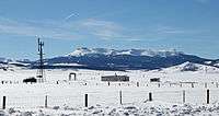
The Flat Tops as seen from State Highway 131 in Routt County | |
| Highest point | |
| Peak | Flat Top Mountain |
| Elevation | 12,361 ft (3,768 m) |
| Coordinates | 39°55′45″N 107°18′17″W / 39.92915°N 107.30478°WCoordinates: 39°55′45″N 107°18′17″W / 39.92915°N 107.30478°W |
| Geography | |
| Country | United States |
| State | Colorado |
| Parent range | Rocky Mountains |
Flat Tops is a mountain range located in Colorado within the Routt and White River National Forests.[1] The area is home to 110 Ponds and Lakes.[2]
Much of the range is within the boundary of the Flat Tops Wilderness Area.
See also
References
External links

This article is issued from Wikipedia - version of the 9/26/2014. The text is available under the Creative Commons Attribution/Share Alike but additional terms may apply for the media files.