Flakstad
| Flakstad kommune | |||
|---|---|---|---|
| Municipality | |||
.jpg) | |||
| |||
 Flakstad within Nordland | |||
| Coordinates: 68°4′45″N 13°16′28″E / 68.07917°N 13.27444°ECoordinates: 68°4′45″N 13°16′28″E / 68.07917°N 13.27444°E | |||
| Country | Norway | ||
| County | Nordland | ||
| District | Lofoten | ||
| Administrative centre | Ramberg | ||
| Government | |||
| • Mayor (2007) | Stein Iversen (Distrikstliste) | ||
| Area | |||
| • Total | 178.14 km2 (68.78 sq mi) | ||
| • Land | 168.81 km2 (65.18 sq mi) | ||
| • Water | 9.33 km2 (3.60 sq mi) | ||
| Area rank | 345 in Norway | ||
| Population (2012) | |||
| • Total | 1,383 | ||
| • Rank | 370 in Norway | ||
| • Density | 8.2/km2 (21/sq mi) | ||
| • Change (10 years) | -10.2 % | ||
| Demonym(s) | Flakstadfjerding[1] | ||
| Time zone | CET (UTC+1) | ||
| • Summer (DST) | CEST (UTC+2) | ||
| ISO 3166 code | NO-1859 | ||
| Official language form | Neutral | ||
| Website |
www | ||
|
| |||

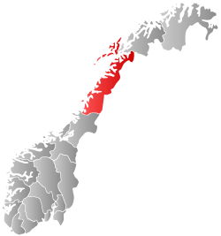
Flakstad is a municipality in Nordland county, Norway. It is part of the traditional district of Lofoten. The administrative centre of the municipality is the village of Ramberg. Other villages include Fredvang and Vareid.
The municipality is located in the Lofoten Islands and comprises the island of Flakstadøya and the northern part of the island of Moskenesøya. The European route E10 highway runs across the whole municipality.
General information

The municipality of Flakstad was established on 1 January 1838 (see formannskapsdistrikt). On 1 July 1916, the southern part of the municipality (population: 1,306) was separated to form the new municipality of Moskenes. This left Flakstad with 1,667 residents.
On 1 January 1964 during a period of municipal mergers, Moskenes (population: 2,001) and Flakstad (population: 2,067) were merged back together. This merger only lasted for twelve years. On 1 January 1976, Moskenes (population: 1,705) and Flakstad (population: 2,007) were divided once again.[2]
Name
The municipality (originally the parish) is named after the old Flakstad farm (Norse Flakstaðir), since the first church (Flakstad Church) was built there. Historically, the name was spelled "Flagstad". The first element could be a Norse nickname (flak meaning "reckless") or it could come from the word flag meaning "rock wall", possibly referring to the large cliff near the church site. The last element is staðir which means "homestead" or "farm".[3][4]
Coat-of-arms
The coat-of-arms is from modern times (1989). The arms show a white fastening device used on boats on a blue background. The fastening device was chosen as a symbol for the community's seafaring history.[5]
Churches
The Church of Norway has one parish (sokn) within the municipality of Flakstad. It is part of the Lofoten deanery in the Diocese of Sør-Hålogaland.
| Parish (Sokn) | Church Name | Location of the Church | Year Built |
|---|---|---|---|
| Flakstad | Flakstad Church | Flakstad | 1780 |
Economy

The municipality's economy is dominated by fishing. The fishing fleet mainly consists of small boats. There are also several fish farm in Flakstad. There is some agriculture in Flakstad, but mostly cattle and sheep farming rather than growing crops.[4]
Government
All municipalities in Norway, including Flakstad, are responsible for primary education (through 10th grade), outpatient health services, senior citizen services, unemployment and other social services, zoning, economic development, and municipal roads. The municipality is governed by a municipal council of elected representatives, which in turn elect a mayor.
Municipal council
The municipal council (Kommunestyre) of Flakstad is made up of 11 representatives that are elected to every four years. Currently, the party breakdown is as follows:[6]
| Party Name | Name in Norwegian | Number of representatives | |
|---|---|---|---|
| Labour Party | Arbeiderpartiet | 2 | |
| Green Party | Miljøpartiet De Grønne | 1 | |
| Centre Party | Senterpartiet | 5 | |
| Local Lists | Lokale lister | 3 | |
| Total number of members: | 11 | ||
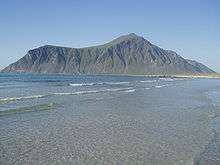
Geography
Located near the southern end of the Lofoten archipelago, Flakstad comprises all of the island of Flakstadøya and the northern part of the island of Moskenesøya. The islands are connected by the Fredvang Bridges and the Kåkern Bridge. The large lake Solbjørnvatnet lies on the northern part of Moskenesøya in Flakstad.
The municipality of Vestvågøy lies to the northeast, the Vestfjorden lies to the southeast, the municipality of Moskenes lies to the southwest, and the Norwegian Sea lies to the northwest.
Climate
| Climate data for Ramberg, Flakstad | |||||||||||||
|---|---|---|---|---|---|---|---|---|---|---|---|---|---|
| Month | Jan | Feb | Mar | Apr | May | Jun | Jul | Aug | Sep | Oct | Nov | Dec | Year |
| Daily mean °C (°F) | −0.3 (31.5) |
−0.5 (31.1) |
0.2 (32.4) |
2.3 (36.1) |
6.3 (43.3) |
9.5 (49.1) |
11.9 (53.4) |
12.0 (53.6) |
8.8 (47.8) |
5.8 (42.4) |
2.6 (36.7) |
0.5 (32.9) |
4.9 (40.8) |
| Average precipitation mm (inches) | 175 (6.89) |
144 (5.67) |
126 (4.96) |
95 (3.74) |
60 (2.36) |
61 (2.4) |
85 (3.35) |
91 (3.58) |
155 (6.1) |
218 (8.58) |
175 (6.89) |
195 (7.68) |
1,580 (62.2) |
| Source: Norwegian Meteorological Institute[7] | |||||||||||||
References
- ↑ "Navn på steder og personer: Innbyggjarnamn" (in Norwegian). Språkrådet. Retrieved 2015-12-01.
- ↑ Jukvam, Dag (1999). "Historisk oversikt over endringer i kommune- og fylkesinndelingen" (PDF) (in Norwegian). Statistisk sentralbyrå.
- ↑ Rygh, Oluf (1905). Norske gaardnavne: Nordlands amt (in Norwegian) (16 ed.). Kristiania, Norge: W. C. Fabritius & sønners bogtrikkeri. p. 347.
- 1 2 Store norske leksikon. "Flakstad" (in Norwegian). Retrieved 2012-06-17.
- ↑ "Kommunevåpenet" (in Norwegian). Flakstad kommune. Retrieved 2008-11-20.
- ↑ "Table: 04813: Members of the local councils, by party/electoral list at the Municipal Council election (M)" (in Norwegian). Statistics Norway. 2015.
- ↑ "eKlima Web Portal". Norwegian Meteorological Institute.
External links
| Wikimedia Commons has media related to Flakstad. |
 Nordland travel guide from Wikivoyage
- Municipal fact sheet from Statistics Norway
