Estanque de Pando
| Estanque de Pando | |
|---|---|
| Suburb of Pando | |
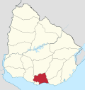
 Estanque de Pando Location in Uruguay | |
| Coordinates: 34°42′0″S 55°58′0″W / 34.70000°S 55.96667°WCoordinates: 34°42′0″S 55°58′0″W / 34.70000°S 55.96667°W | |
| Country |
|
| Department | Canelones Department |
| Population (2011) | |
| • Total | 770 |
| Time zone | UTC -3 |
| Postal code | 91000 |
| Dial plan | +598 2 (+7 digits) |
Estanque de Pando is a northern suburb of Pando in the Canelones Department of southern Uruguay.
Location
It is located on Route 75, about 2 kilometres (1.2 mi) north of Pando. It lies between the suburbs San Bernardo - Viejo Molino and Jardines de Pando.
Population
In 2011 Estanque de Pando had a population of 770.[1]
| Year | Population |
|---|---|
| 1985 | 296 |
| 1996 | 365 |
| 2004 | 641 |
| 2011 | 770 |
Source: Instituto Nacional de Estadística de Uruguay[2]
References
- ↑ "Censos 2011 Canelones (flash plugin needed)". INE. 2012. Retrieved 25 August 2012.
- ↑ "1963–1996 Statistics / E" (DOC). Instituto Nacional de Estadística de Uruguay. 2004. Retrieved 29 June 2011.
External links
Capital: Canelones | ||
| Towns and villages |
|  |
| Resorts of the Ciudad de la Costa | ||
| Sights |
| |
This article is issued from Wikipedia - version of the 11/4/2014. The text is available under the Creative Commons Attribution/Share Alike but additional terms may apply for the media files.