Progreso, Uruguay
| Progreso | |
|---|---|
| City | |
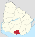
 Progreso Location in Uruguay | |
| Coordinates: 34°39′54″S 56°13′10″W / 34.66500°S 56.21944°WCoordinates: 34°39′54″S 56°13′10″W / 34.66500°S 56.21944°W | |
| Country |
|
| Department | Canelones Department |
| Founded | 1871 |
| Elevation | 70 m (230 ft) |
| Population (2011) | |
| • Total | 16,244 |
| Time zone | UTC -3 |
| Postal code | 90300 |
| Dial plan | +598 2 (+7 digits) |
Progreso is a city in the Canelones Department of southern Uruguay.
Progreso is also the name of the municipality to which the city belongs.
Location
The city is located on the old Route 5 (which runs parallel to the railway track Montevideo - Santa Lucia), about 29 kilometres (18 mi) from the centre of Montevideo. It belongs to the wider metropolitan area of Montevideo.
History
The city was founded on 15 November 1871 under the name of Progreso, the Spanish term for «Progress». However, prior to 1871, the place where the current city is located received the name of Puntas del Canelón Chico or Arroyo del Gigante.[1]
The name Progreso is due to the arrival of the railway in 1871, which was introduced into Uruguay by the English.[1]
The railway system enabled the place to expand itself beyond its original borders and to achieve, at the same time, some sort of economic prosperity. The railway system also resulted in the establishment of some English families near the industrial area of the city. Today the wooded avenue that leads to the railway station is known as the Avenida de los Ingleses, meaning «Avenue of the Englishmen». The neighborhood where this station is located is known as the Villa Inglesa, «English Village».[1]
Its status was elevated to "Pueblo" (village) category on 1 July 1953 by the Act of Ley Nº 11.968,[2] and then on 11 December 1981 to "Ciudad" (city) by the Act of Ley Nº 15.228.[3]
Present-day Progreso, despite its name, ranks high in Uruguay as far as the unemployment rate is concerned.
Population
According to the 2011 census, Progreso had a population of 16,244.[4] In 2010, the Intendencia de Canelones had estimated a population of 19,578 for the municipality during the elections.[5]

| Year | Population |
|---|---|
| 1963 | 7,010 |
| 1975 | 9,612 |
| 1985 | 11,244 |
| 1996 | 14,471 |
| 2004 | 15,775 |
| 2011 | 16,244 |
Source: Instituto Nacional de Estadística de Uruguay[6]
Places of worship
- St. Anthony Mary Claret Parish Church (Roman Catholic, Claretians)[7]
- St. Mary of the Visitation Monastery (Roman Catholic, Visitandines)
Government
The city mayor as of July 2010 is Cristina Castro.[8]
References
- 1 2 3 tacuy.com.uy: Information about the Canelones Department, a brief historical survey (Spanish)
- ↑ "LEY N° 11.968". República Oriental del Uruguay, Poder Legislativo. 1952. Retrieved 8 September 2012.
- ↑ "Ley Nº 15.228". República Oriental del Uruguay, Poder Legislativo. 1981. Retrieved 8 September 2012.
- ↑ "Censos 2011 Cuadros Canelones". INE. 2012. Retrieved 25 August 2012.
- ↑ "ELECCIONES - Canelones". El Observador. Retrieved 2 February 2012.
- ↑ "Statistics of urban localities (1963–2004)" (PDF). INE. 2012. Retrieved 8 September 2012.
- ↑ Claretians in Progreso (Spanish)
- ↑ "MUNICIPIOS DE URUGUAY" at the Intendents' Congress website (Spanish)
External links
- www.progreso.com.uy (Spanish)
- INE map of Progreso
Capital: Canelones | ||
| Towns and villages |
|  |
| Resorts of the Ciudad de la Costa | ||
| Sights |
| |