Villa El Tato
| Villa El Tato | |
|---|---|
| Urban fragment | |
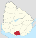
 Villa El Tato Location in Uruguay | |
| Coordinates: 34°46′30″S 55°58′25″W / 34.77500°S 55.97361°WCoordinates: 34°46′30″S 55°58′25″W / 34.77500°S 55.97361°W | |
| Country |
|
| Department | Canelones Department |
| Population (2011) | |
| • Total | 615 |
| Time zone | UTC -3 |
| Postal code | 91001 |
| Dial plan | +598 2 (+7 digits) |
Villa El Tato is an urban fragment (fraccionamiento) in the Canelones Department of southern Uruguay. It is part of the wider metropolitan area of Montevideo.
Location
It is one of several urban fragments that are situated among the city of Pando to the northeast, Joaquín Suárez to the northwest, Colonia Nicolich and the Carrasco International Airport to the southwest and Ciudad de la Costa to the south and southeast. It is located on the street Camino de los Horneros, which is the first parallel east of Route 101.
Population
In 2011 Villa El Tato had a population of 615.[1]
| Year | Population |
|---|---|
| 1985 | 198 |
| 1996 | 406 |
| 2004 | 508 |
| 2011 | 615 |
Source: Instituto Nacional de Estadística de Uruguay[2]
References
- ↑ "Censos 2011 Canelones (flash plugin needed)". INE. 2012. Archived from the original on September 7, 2012. Retrieved 25 August 2012.
- ↑ "1963–1996 Statistics / V" (DOC). Instituto Nacional de Estadística de Uruguay. 2004. Retrieved 13 July 2011.
External links
Capital: Canelones | ||
| Towns and villages |
|  |
| Resorts of the Ciudad de la Costa | ||
| Sights |
| |
This article is issued from Wikipedia - version of the 9/13/2016. The text is available under the Creative Commons Attribution/Share Alike but additional terms may apply for the media files.