Elsterwerda
Elsterwerda (Lower Sorbian: Wikow) is a town in the Elbe-Elster district, in southwestern Brandenburg, Germany. It is situated on the Black Elster river, 48 km northwest of Dresden, and 11 km southeast of Bad Liebenwerda.
Demography
Development of Population since 1875 within the Current Boundaries (Blue Line: Population; Dotted Line: Comparison to Population Development of Brandenburg state; Grey Background: Time of Nazi rule; Red Background: Time of Communist rule)
Recent Population Development (Blue Line) and Forecasts
Elsterwerda:
Population development within the current boundaries (2013)[2]
| Year |
Population |
|---|
| 1875 | 3 193 |
| 1890 | 3 705 |
| 1910 | 7 024 |
| 1925 | 8 359 |
| 1933 | 8 738 |
| 1939 | 9 560 |
| 1946 | 10 966 |
| 1950 | 11 461 |
| 1964 | 11 157 |
| 1971 | 11 443 |
|
|
| Year |
Population |
|---|
| 1981 | 11 572 |
| 1985 | 11 517 |
| 1989 | 11 255 |
| 1990 | 11 033 |
| 1991 | 10 947 |
| 1992 | 10 868 |
| 1993 | 10 793 |
| 1994 | 10 726 |
| 1995 | 10 656 |
| 1996 | 10 538 |
|
|
| Year |
Population |
|---|
| 1997 | 10 442 |
| 1998 | 10 382 |
| 1999 | 10 334 |
| 2000 | 10 234 |
| 2001 | 9 937 |
| 2002 | 9 911 |
| 2003 | 9 804 |
| 2004 | 9 654 |
| 2005 | 9 456 |
| 2006 | 9 249 |
|
|
| Year |
Population |
|---|
| 2007 | 9 096 |
| 2008 | 8 959 |
| 2009 | 8 817 |
| 2010 | 8 694 |
| 2011 | 8 498 |
| 2012 | 8 384 |
| 2013 | 8 287 |
|
|
Gallery
City
Church „St. Katharina“
City hall
Miniature park
Windmill
War memorial
Water tower
Railway station
Notable people

Maria Josepha of Austria 1720
- Maria Josepha of Austria (1699-1757), Austrian princess
- Charles of Saxony, Duke of Courland (1733-1796), Saxon prince,
- Johann Gottlob Theaenus Schneider (1750-1822), classicist and naturalist, spent his childhood in Elsterwerda
- Johannes Gillhoff (1861-1930), teacher and author
- Erich Straube (1887-1971), officer in WW I and WW II
- Bernd Martin (born 1940), historian, grew up in Elsterwerda
- Siegbert Horn (1950-2016), canoeist, Olympic and World Champion
- Ralf Minge (born 1960), football player and coach
References
External links


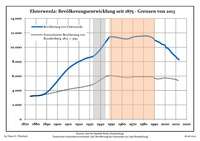 Development of Population since 1875 within the Current Boundaries (Blue Line: Population; Dotted Line: Comparison to Population Development of Brandenburg state; Grey Background: Time of Nazi rule; Red Background: Time of Communist rule)
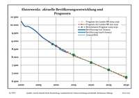 Recent Population Development (Blue Line) and Forecasts
 City
City Church „St. Katharina“
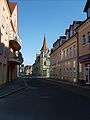 City hall
 Miniature park
 Windmill
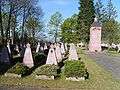 War memorial
 Water tower
 Railway station