Black Elster
| Black Elster | |
|---|---|
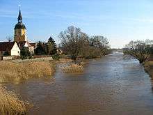 The Black Elster in Schweinitz. | |
| Native name | Schwarze Elster |
| Country | Germany |
| Basin | |
| Main source |
Upper Lusatia 317 m (1,040 ft) |
| River mouth |
Elbe 51°48′59″N 12°49′57″E / 51.81639°N 12.83250°ECoordinates: 51°48′59″N 12°49′57″E / 51.81639°N 12.83250°E |
| Basin size | 5,541 km2 (2,139 sq mi) |
| Physical characteristics | |
| Length | 179 km (111 mi) |
The Black Elster[1][2][3] or Schwarze Elster is a 179-kilometre (111 mi) long river in eastern Germany, in the states Saxony, Brandenburg and Saxony-Anhalt, right tributary of the Elbe. Its source is in the Upper Lusatia region, near Elstra.
The Black Elster flows through the cities Kamenz, Hoyerswerda, Senftenberg, Lauchhammer, Elsterwerda, Bad Liebenwerda, Herzberg and Jessen. It flows into the river Elbe at Elster (Elbe), upstream from Wittenberg.
Geography
The river rises in the Lusatian Highlands (Upper Lusatia) about 1.5 kilometres (0.9 mi) south of the village Kindisch in the borough of Elstra on the eastern flank of the 396-metre (1,299 ft) high Kuppe, a subpeak of the Hochstein. From here the Black Elster flows initially in a northerly direction through Elstra, Kamenz, Milstrich and Wittichenau, from Hoyerswerda it flows in a westwards to Elsterheide. Further downstream, after 63 kilometres (39 mi), it crosses the Saxon-Brandenburg border and flows though Senftenberg, Ruhland and Lauchhammer to Elsterwerda. From here it heads in a northwesterly direction through Bad Liebenwerda, Herzberg and Jessen before emptying into the Elbe in the municipality of Elster (Elbe) (river kilometre 198.5).
The most important tributaries of the Black Elster are the Hoyerswerdaer Schwarzwasser, the Pulsnitz, the Große Röder, the Kleine Elster and the Schweinitzer Fließ.
Tributaries
| Left tributaries | Right tributaries |
|---|---|
|
|
History
Field Marshal Blücher crossed the Elbe River near its confluence with the Black Elster on 3 Oct 1813 on his march to Leipzig.[4]
See also
- There is also a White Elster river in eastern Germany.
References
- ↑ Saxony Archived November 23, 2010, at the Wayback Machine. at 1911 Britannica Encyclopedia. Accessed on 6 Nov 2010.
- ↑ Elbe River Basin by the International Commission for the Protection of the Elbe River. Accessed on 16 Jan 2011.
- ↑ Elbe at waterwiki.net. Accessed on 16 Jan 2011.
- ↑ Wright, George Newenham (1836). A New and Comprehensive Gazetteer, Volume 3, p. 78.