Schlieben
| Schlieben | ||
|---|---|---|
|
General view of Schlieben with the bell tower of historic St Martins Church | ||
| ||
 Schlieben | ||
Location of Schlieben within Elbe-Elster district 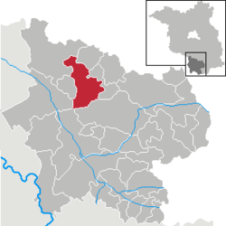 | ||
| Coordinates: 51°43′00″N 13°22′59″E / 51.71667°N 13.38306°ECoordinates: 51°43′00″N 13°22′59″E / 51.71667°N 13.38306°E | ||
| Country | Germany | |
| State | Brandenburg | |
| District | Elbe-Elster | |
| Municipal assoc. | Schlieben | |
| Government | ||
| • Mayor | Helmut Richter (SPD) | |
| Area | ||
| • Total | 78.22 km2 (30.20 sq mi) | |
| Population (2015-12-31)[1] | ||
| • Total | 2,452 | |
| • Density | 31/km2 (81/sq mi) | |
| Time zone | CET/CEST (UTC+1/+2) | |
| Postal codes | 04936 | |
| Dialling codes | 035361 | |
| Vehicle registration | EE | |
| Website | www.schlieben.com | |


Schlieben is a town in the Elbe-Elster district, in southwestern Brandenburg, Germany. It is situated 22 km north of Bad Liebenwerda. Schlieben was the site of a concentration camp during the Holocaust.
Demography
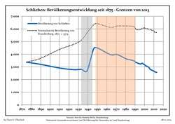
| Schlieben population development within the current boundaries (2013)[2] | ||||||||||||||||||||||||||||||||||||||||||||||||||||||||||||||||||||||||||||||||||||||||||||||||||||||||||||||||||||||
|---|---|---|---|---|---|---|---|---|---|---|---|---|---|---|---|---|---|---|---|---|---|---|---|---|---|---|---|---|---|---|---|---|---|---|---|---|---|---|---|---|---|---|---|---|---|---|---|---|---|---|---|---|---|---|---|---|---|---|---|---|---|---|---|---|---|---|---|---|---|---|---|---|---|---|---|---|---|---|---|---|---|---|---|---|---|---|---|---|---|---|---|---|---|---|---|---|---|---|---|---|---|---|---|---|---|---|---|---|---|---|---|---|---|---|---|---|---|---|
|
| |||||||||||||||||||||||||||||||||||||||||||||||||||||||||||||||||||||||||||||||||||||||||||||||||||||||||||||||||||||
References
- ↑ "Bevölkerung im Land Brandenburg nach amtsfreien Gemeinden, Ämtern und Gemeinden 31. Dezember 2015 (Fortgeschriebene amtliche Einwohnerzahlen auf Grundlage des Zensus 2011)". Amt für Statistik Berlin-Brandenburg (in German). 2016.
- ↑ Detailed data sources are to be found in the Wikimedia Commons.Population Projection Brandenburg at Wikimedia Commons
This article is issued from Wikipedia - version of the 2/9/2016. The text is available under the Creative Commons Attribution/Share Alike but additional terms may apply for the media files.