East Stour, Dorset
| East Stour | |
 East Stour |
|
 East Stour |
|
| Population | 573 [1] |
|---|---|
| OS grid reference | ST |
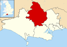
| District | North Dorset |
| Shire county | Dorset |
| Region | South West |
| Country | England |
| Sovereign state | United Kingdom |
| Post town | GILLINGHAM |
| Postcode district | SP8 |
| Dialling code | 01747 |
| Police | Dorset |
| Fire | Dorset and Wiltshire |
| Ambulance | South Western |
| EU Parliament | South West England |
| UK Parliament | North Dorset |
Coordinates: 51°00′19″N 2°17′15″W / 51.0053°N 2.2874°W
East Stour is a village and civil parish in the county of Dorset in southern England. It lies within the North Dorset administrative district, about 2 miles (3.2 km) south of the town of Gillingham. The village is sited half a mile from the east bank of the River Stour in the Blackmore Vale and two miles west of the broadly conical local landmark Duncliffe Hill (210 m). Above the west bank of the river, about a mile away, is the village of West Stour. The A30 London to Penzance road passes through the village. In the 2011 census the civil parish had a population of 573.[1]
History
Part of the shaft of a cross, probably dating from the late 10th or early 11th century, was found in 1939 when a house in the village was demolished. The stone fragment has a cross-section a little under 30 centimetres (12 in) square and is about 70 centimetres (28 in) high; its faces are embellished with vine-scroll, interlace and palmette ornament. It was transferred to the British Museum.[2]
In the Domesday Book of 1086 East Stour and West Stour together were recorded as Stur or Sture,[3] which had 73 households and administratively was in Gillingham Hundred.[4] A 1695 map shows the village name as Stower Estover.
East Stour village was the original settlement in the parish, with study of field boundaries suggesting that encroachment on the "waste" or common land subsequently occurred eastwards, initially immediately east of the village, then further east in post-medieval times. The farms at New House and Cole Street in the northeast of the parish date from settlement in the late 18th century, and in the southeast the waste was enclosed in 1804.[2]
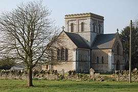
The parish church was rebuilt in 1841–42 near the site of its predecessor, from which the Norman stone font was retrieved.[5]
Governance
East Stour is in the electoral ward called The Stours, which extends southeast as far as East Orchard and in the 2011 census had a population of 1,786.[6] The ward is part of the constituency of North Dorset, and is currently represented in the UK parliament by the Conservative Simon Hoare.[7]
In local government East Stour is governed by Dorset County Council at the county level and North Dorset District Council at the district level.[8] At the parish level East Stour is one of four parishes—the others being Todber, Stour Provost and West Stour—under the governance of The Stours Parish Council, which is a grouped parish council.[9]
Geography
The underlying geology of the parish is Corallian Limestone in the west and Kimmeridge clay in the east, with gault clay around the greensand of Duncliffe Hill.[2] The village is on the limestone.[10]
Demography
In the 2011 census East Stour civil parish had 267 dwellings,[11] 251 households and a population of 573.[1] 26.2% of residents were age 65 or over, compared to 16.4% for England as a whole.[12]
Amenities
East Stour has a village hall[13] and two public houses: The Crown Inn on the B3092 towards Gillingham and The Kings Arms at East Stour Common.[14][15]
Notable residents
The writer and magistrate Henry Fielding (1707—1754), who also founded the Bow Street Runners, lived in the manor house for three years, after inheriting it. During this time he spent his fortune and consequently became a professional writer. The house, sited west of the church, was demolished in 1835, though its mullioned windows were probably incorporated into its replacement, which previously was called Fielding's Farm but in 1919 became Church Farm.[16][17]
References
- 1 2 3 "Area: East Stour (Parish). Key Figures for 2011 Census: Key Statistics". Neighbourhood Statistics. Office for National Statistics. Retrieved 6 July 2014.
- 1 2 3 "'East Stour', An Inventory of the Historical Monuments in Dorset, Volume 4: North (1972), pp. 16–17". British History Online. University of London & History of Parliament Trust. November 2013. Retrieved 6 July 2014.
- ↑ "Dorset S–Z". The Domesday Book Online. domesdaybook.co.uk. Retrieved 7 July 2014.
- ↑ "Place: [East and West] Stour". Open Domesday. domesdaymap.co.uk. Retrieved 8 July 2014.
- ↑ North Dorset District Council, North Dorset District Official Guide, Home Publishing Co. Ltd., c.1983, p33
- ↑ "The Stours". ukcensusdata.com. Retrieved 1 March 2015.
- ↑ "Dorset North Parliamentary constituency". Election 2015. BBC. Retrieved 10 May 2015.
- ↑ "Parish and town councils in North Dorset". dorsetforyou.com. Dorset County Council. 5 March 2015. Retrieved 15 March 2015.
- ↑ "Welcome to The Stours Parish Council Website". The Stours Group Parish Council. Retrieved 15 March 2015.
- ↑ Ralph Wightman (1983). Portrait of Dorset (4 ed.). Robert Hale Ltd. p. 17. ISBN 0-7090-0844-9.
- ↑ "Area: East Stour (Parish). Dwellings, Household Spaces and Accommodation Type, 2011 (KS401EW)". Neighbourhood Statistics. Office for National Statistics. Retrieved 15 March 2015.
- ↑ "Area: East Stour (Parish). Age Structure, 2011 (KS102EW)". Neighbourhood Statistics. Office for National Statistics. Retrieved 15 March 2015.
- ↑ "East Stour Village Hall". Dorset Halls Network. Dorset Village Halls Association. 2012. Retrieved 15 March 2015.
- ↑ "The Crown Inn". pub-explorer.com. Retrieved 15 March 2015.
- ↑ "The Kings Arms". kingsarmseaststour.com. Retrieved 15 March 2015.
- ↑ Hyams, John (1970). Dorset. B T Batsford Ltd. p. 201. ISBN 0-7134-0066-8.
- ↑ White, Steve; Hannay, Clive (November 2011). "From Shaftesbury towards Stalbridge". Dorset Life Magazine. Retrieved 22 September 2015.
External links
| Wikimedia Commons has media related to East Stour, Dorset. |