Eifel
| Eifel | |
|---|---|
 Map of the Eifel | |
| Highest point | |
| Peak | Hohe Acht |
| Elevation | 747 m (2,451 ft) |
| Dimensions | |
| Length | 100 km (62 mi) |
| Area | 5,300 km2 (2,000 sq mi) |
| Geography | |
| Countries | Germany, Belgium and Luxembourg |
| States | Rhineland-Palatinate and North Rhine-Westphalia |
| Range coordinates | 50°23′N 6°52′E / 50.39°N 6.87°ECoordinates: 50°23′N 6°52′E / 50.39°N 6.87°E |
| Parent range | Rhenish Slate Mountains |
| Geology | |
| Orogeny | low mountains |
| Type of rock | slate, limestone, quartzite, sandstone, basalt |


The Eifel (Luxembourgish: Äifel) is a low mountain range in western Germany and eastern Belgium. It occupies parts of southwestern North Rhine-Westphalia, northwestern Rhineland-Palatinate and the south of the German-speaking Community of Belgium.
The Eifel is part of the Rhenish Massif; within its northern portions lies the Eifel National Park.
Geography
Location

The Eifel lies between the cities of Aachen to the north, Trier to the south and Koblenz to the east. It descends in the northeast along a line from Aachen via Düren to Bonn into the Lower Rhine Bay. In the east and south it is bounded by the valleys of the Rhine and the Moselle. To the west it transitions in Belgium and Luxembourg into the geologically related Ardennes and the Luxembourg Ösling. In the north it is limited by the Jülich-Zülpicher Börde. Within Germany it lies within the states of Rhineland-Palatinate and North Rhine-Westphalia; in BeNeLux the area of Eupen, St. Vith and Luxembourg. Its highest point is the volcanic cone of the Hohe Acht (746.9 m). Originally the Carolingian Eifelgau only covered the smaller region roughly around the sources of the rivers Ahr, Kyll, Urft and Erft. Its name was more recently transferred to the entire region.
Topography
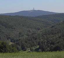
The Eifel belongs to that part of the Rhenish Massif whose rolling plateau is categorised as peneplain highland (Rumpfhochland), which was formed by the erosion of the ancient mountains of the Variscan mountain building phase and subsequent further uplifting. Individual mountain chains, up to 700 m, such as the Schneifel and High Fens, run through the western part of the plateau. In the eastern part, in the High Eifel and Volcanic Eifel, individual cinder cones and basalt kuppen, like the Hohe Acht and the Ernstberg, emerged as a result of volcanicity in the Tertiary and Quaternary periods and rise above the undulating countryside.
The rivers draining into the Moselle, Rhine and Meuse, such as the Our, Kyll, Ahr, Brohl and Rur, have cut deep into the edge of the Eifel and formed larger valleys.
The Eifel covers an area of 5,300 km² and is geographically divided into the North and South Eifel. It is further divided into several natural regional landscapes, some with further subdivisions.
Divisions
There are several distinct chains within the Eifel.
- The northernmost parts are called North Eifel ("Nordeifel") including Rur Eifel the origin of the river Rur, High Fens ("Hohes Venn") and the Limestone Eifel ("Kalkeifel").
- The northeastern part is called Ahr Hills[1] (German: Ahrgebirge) and rise north of the Ahr river in the district of Ahrweiler.
- South of the Ahr is the High Eifel[1] (Hohe Eifel), with the Hohe Acht (747 m) being the highest mountain of the Eifel.
- In the west, on the Belgian border, the hills are known as Schneifel (part of the Schnee-Eifel or "Snowy Eifel"), rising up to 698 m. Also in the west, by the Belgian and Luxembourg border, the region is known as Islek (Aquilania).
- The southern half of the Eifel is lower. It is cut by several rivers running north-south towards the Moselle. The largest of these is the Kyll, and the hills on either side of this river are called the Kyllwald.
- In the south the Eifel is concluded by the Voreifel above the Moselle.
Since 2004 about 110 km² of the Eifel within the German state of North Rhine-Westphalia have been protected as the Eifel National Park nature reserve.
Waterbodies


Due to its moist and mild Atlantic climate, the Eifel bisected by numerous streams and small rivers. Impoundment of these streams, especially in the North Eifel has led to the creation of very large reservoir, such as the Rursee, which is the second largest in Germany by volume, and the Urftsee.
A feature of the Eifel are its natural lakes of volcanic origin. The largest, the Laacher See, is a collapsed, water-filled caldera, whilst the many maars are water-filled volcanic eruption bowls. The largest maar lake is the Pulvermaar. The Meerfelder Maar has an even bigger basin, but three-quarters of it has silted up.
Rivers and streams
The many rivers and streams of the Eifel drain into the North Sea via the great rivers outside of the Eifel: the Rhine (and its tributary, the Moselle) and the Meuse (with its tributaries, the Rur and Ourthe). The rivers and streams within the mountain range, together with their larger tributaries, are as follows:
|
Rhine tributaries:
|
Meuse tributaries: |
Lakes and reservoirs
|
Reservoirs
|
Volcanic lakes
|
 Reservoirs of the Eifel that drain into the Rur |
Geology
The Eifel and its western continuation into Belgium, the Ardennes, are a part of the Variscan mountain belt and belong to the Rhenish Massif (Rheinisches Schiefergebirge).
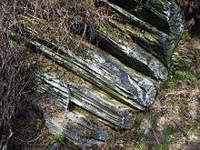
The Eifel consists mainly of Devonian slates, sandstones and limestones, laid down in an ocean south of the Old Red Continent[2] and folded and overthrust in the Variscan orogeny. The Eifel geological structures like main folds and overthrusts can be traced in a SW-NE direction far beyond the Rhine valley.
Eifel volcanic area
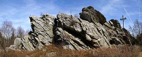
In the Tertiary and Quaternary geological eras, the Eifel was a site of extensive volcanic activity. Some of the hills are volcanic vents. The peculiar circle-shaped lakes (maars) of the volcanic regions formed in volcanic craters. The last volcanic eruptions in the Laacher See volcanic site took place around 10,000 years ago and generated a huge volume of volcanic ash, now found in thin ash layers in contemporaneous sediments throughout Europe. The volcanism of the Eifel is thought to be partly caused by the Eifel hotspot, a place where hot material from deep in the mantle rises to the surface, and partly by melt-ascent at deep fractures in the Earth's crust.[3] Research has shown that the volcanism is still active; the Eifel region is rising by 1–2 mm per year.
Historically, the Eifel volcanoes had inactive phases of 10,000 to 20,000 years between active phases, suggesting there is a possibility of future eruptions.
Castles


Well preserved
- Eltz Castle
- Lissingen Castle
- Satzvey Castle
- Dudeldorf Castle
- Schloss Eicks
19th- and 20th-century rebuilds
- Bollendorf Castle
- Genovevaburg
- Vlatten Castle
- Cochem Castle
Ruins
- Gerolstein Castle
- Gödersheim Castle
- Löwenburg and Philippsburg
- Manderscheid castles
- Monschau Castle
- Nideggen Castle
- Schönecken Castle
- Ulmen castles
- Nürburg Castle
Mountains and hills

The mountains and hills of the Eifel include the following (in order of height in metres above sea level):
- Hohe Acht (747 metres (2,451 ft)), High Eifel
- Ernstberg (or Erresberg) (698.8 metres (2,293 ft)), High Eifel
- Schwarzer Mann (697.3 metres (2,288 ft)), Schnee Eifel
- Signal de Botrange (694 metres (2,277 ft)), High Fens (Hohes Venn, Hautes Fagnes)
- Weißer Stein (692 metres (2,270 ft)), North Eifel
- Scharteberg (691 metres (2,267 ft)), Volcanic Eifel
- Nürburg (678 metres (2,224 ft)), with the castle of the same name (Nürburg Castle), High Eifel
- Prümscheid (675 metres (2,215 ft)), High Eifel
- Raßberg (667 metres (2,188 ft)), High Eifel
- Steling (658 metres (2,159 ft)), High Fens
- Nerother Kopf (647 metres (2,123 ft)), Volcanic Eifel
- Aremberg (623 metres (2,044 ft)), Ahr Hills
- Dietzenley (617 metres (2,024 ft)), Gerolstein / Volcanic Eifel
- Hardtkopf (596 m), South Eifel
- Michelsberg (588 m), Ahr Hills
- Hochsimmer (587.9 m), East Eifel
- Eigart (565 m), North Eifel
- Rockeskyller Kopf (555 m), Volcanic Eifel
- Hoher List (549 m), Volcanic Eifel
- Wildbretshügel (525.3 m), Rur Eifel, Kermeter
- Kalvarienberg (Alendorf) (523 m), North Eifel
- Kirchberg (520 m), North Eifel
- Häuschen (507 m), North Eifel
- Hochthürmen (499.8 m), North Eifel
- Teufelsley (496 m), North Eifel
- Kellerberg (448 m), Meulenwald
- Stockert (435 m), Münstereifel Forest
- Herkelstein (435 m), North Eifel
- Veitskopf (428 m), Volcanic Eifel
- Burgberg (400.5 m), Rur Eifel, North Eifel
- Sonnenberg (393,3 m), Rur Eifel
- Calmont (378 m), Pre-Eifel
- Bausenberg (340 m), North Eifel
- Landskrone (272 m), Ahr Hills
For a list of these and other Eifel mountains and hills see the List of mountains and hills of the Eifel.
Points of interest
- The Nürburgring, one of the world's most famous motor-racing courses. The northern loop (Nordschleife) of the course is known as the Green Hell (Grüne Hölle), because of its long, difficult and dangerous course through the local forest.
- The Eifel Aqueduct, an interesting archeological feature. One of the longest aqueducts of the Roman empire, it provided water to the Roman settlement of Colonia Claudia Ara Agrippinensium (modern-day Cologne).
See also
|
References
External links
| Wikivoyage has a travel guide for Eifel. |
| Wikimedia Commons has media related to Eifel. |
 "Eifel". Encyclopædia Britannica. 9 (11th ed.). 1911.
- Historical Background: The Eifel District

Subdivisions of the Rhenish Massif | ||
|---|---|---|
 | ||