Urft (river)
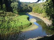 | |
| The Urft near Gemünd in the Urft Reservoir at low water | |
| Location | In the North Eifel; Euskirchen, North Rhine-Westphalia |
|---|---|
| Reference no. | DE: 2822 |
| Length | 46.373 km (28.815 mi) [1] |
| Source | In the North Eifel near Schmidtheim 50°25′05″N 6°30′12″E / 50.41806°N 6.503361°ECoordinates: 50°25′05″N 6°30′12″E / 50.41806°N 6.503361°E |
| Source height | ca. 581 m above sea level (NHN) |
| Mouth | Near Rurberg into the Rur / in the upper basin of the Rur Dam 50°36′08″N 6°25′07″E / 50.602306°N 6.418639°E |
| Mouth height | 279.6 m above sea level (NHN) |
| Descent | ca. 301.4 m |
| Basin | Rhine |
| Progression | Rur → Meuse → Hollands Diep → North Sea |
| Catchment | 372.564 km2 (143.848 sq mi) [1] |
| Right tributaries | Genfbach (for this and others see below) |
| Left tributaries | Olef (for this and others see below) |
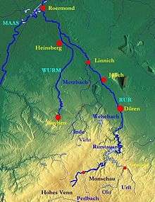 | |
| The Rur inter alia with the courses of the Urft, Inde, Merzbach and Wurm | |
The Urft is a 46.4-kilometre-long (28.8 mi) right-hand tributary of the Rur in the county of Euskirchen in the German state of North Rhine-Westphalia.[1] It flows through the village of Urft in the municipality of Kall. The Urft rises in the North Eifel region of the Eifel Mountains.
Origin of the name
The name of the Urft is derived from Urd-apa.[2] The origin of the word Urd is unknown, but apa is Celtic and means "stream".[2] In 1075, the Urft was called the Urdefa, in 1419 the Orfft and, in 1503, the Oyrfft.[2] The village of Urft takes its name from the river.[2]
Course
The Urft rises in the North Eifel in the High Fens-Eifel Nature Park. Its source is in the Dahlem Forest (Dahlemer Wald), 3.8 km (2.4 mi) west of the Dahlem village of Schmidtheim and 2.3 km (1.4 mi) (both as the crow flies) northwest of Dahlemer Binz Airfield.
The Urft initially flows through Schmidtheim. From there it is accompanied by the Eifel Line and joined by the Dänenbach stream. It then flows through the village of Blankenheim-Wald, where it collects the Wisselbach and is crossed by the B 258 federal highway. In the next section it is joined by more streams including the Treisbach, the Laufbach and the Haubach. At Steinrütsch, which lies in the parish of Nettersheim and where there are the remains of a Roman burgus and castellum (Kleinkastell), it is joined by the Wellenbach in Urft and in Nettersheim the Genfbach. Next the river runs parallel to the Roman Eifel Aqueduct, which begins at the old Gronrecht Mill (Gronrechtsmühle) near the Grüner Pütz, flows through Urft, where it meets the Gillesbach and, below the village, the Kuttenbach. After that the Urft flows through Sötenich and Kall, where it leaves both the Eifel Line and the Eifel Aqueduct and collects the Kallbach, before running along the Olef Valley Railway and through Anstois. Next it passes through Gemünd, where the Olef joins and where the B 265 and B 266 cross the Urft in the village. It then leaves the railway and flows through Malsbenden.
Next the Urft flows into the Urft Reservoir, which channels its waters usually into a tunnel - the Kermeter Gallery - through the Kermeter ridge north of the reservoir and through the turbines of the Heimbach Power Station with its outflow into the compensating basin of the Heimbach Dam and thus eventually into the River Rur. Through this artificial outflow tunnel the mouth of the Urft is near the Heimbach village of Hasenfeld at Rur 111.1 km (69.0 mi).[1] Before the construction of the Urft Dam, the river emptied in a natural way above the Simmerath village of Rurberg roughly at Rur 123.5 km (76.7 mi) into the Rur.[1] Since the second expansion stage of the Rur Reservoir in 1959 the water from the Obersee on the Rur Dam impounds the old lower reaches of the Urft (near its confluence) on the downstream side of the Urft Dam to a depth of around 12 metres (39 ft). From there the reservoir waters flow, at high water, over the spillway of the Urft Dam.[3]
Catchment area and tributaries
The catchment area of the Urft covers 372.564 km2 (143.85 sq mi),[1] and drains via the Rur, Meuse and Hollands Diep into the North Sea.
| Tributaries of the Urft[4] | |||||||||
|---|---|---|---|---|---|---|---|---|---|
| GKZ | Name | Length | Catchment | Direction | Confluence | Confluence | |||
| km | mi | km2 | sqmi | km | mi | location | |||
| 2822112 | N.N. | 1.7 | 1.1 | left | 43.8 | 27.2 | |||
| 2822114 | N.N. | 2.5 | 1.6 | left | 43.6 | 27.1 | |||
| 2822116 | N.N. | 1.9 | 1.2 | right | 43.7 | 27.2 | |||
| 282212 | Dänenbach | 5.7 | 3.5 | 4.784 | 1.847 | left | 40.1 | 24.9 | Schmidtheim |
| 2822132 | Zehnbach | 1.3 | 0.8 | right | 39.5 | 24.5 | |||
| 282214 | Wisselbach | 3.5 | 2.2 | 2.314 | 0.893 | left | 38.3 | 23.8 | Blankenheim-Wald |
| 2822152 | Schäferbach | 1.7 | 1.1 | right | 37.8 | 23.5 | Blankenheim-Wald | ||
| 2822154 | N.N. | 0.9 | 0.6 | right | 37.1 | 23.1 | |||
| 2822156 | Treisbach | 2.8 | 1.7 | left | 36.2 | 22.5 | |||
| 282216 | Haubach | 3.4 | 2.1 | 7.057 | 2.725 | right | 35.2 | 21.9 | |
| 2822172 | Laufbach | 2.2 | 1.4 | left | 34.9 | 21.7 | |||
| 2822174 | Lützertseifen | 1.5 | 0.9 | right | 34.5 | 21.4 | |||
| 2822176 | Gelensiefen | 1.4 | 0.9 | left | 33.3 | 20.7 | |||
| 2822178 | Wellenbach | 2.5 | 1.6 | right | 31.7 | 19.7 | |||
| 282218 | Schleifbach | 3.9 | 2.4 | 3.961 | 1.529 | left | 30.8 | 19.1 | Nettersheim |
| 28222 | Genfbach | 9.6 | 6.0 | 20.102 | 7.761 | right | 29.4 | 18.3 | Nettersheim |
| 28224 | Gillesbach | 6.6 | 4.1 | 15.644 | 6.040 | left | 23.2 | 14.4 | Urft |
| 282252 | Kuttenbach | 5.3 | 3.3 | 4.488 | 1.733 | left | 22.3 | 13.9 | Urft |
| 28226 | Kallbach | 7.2 | 4.5 | 15.007 | 5.794 | left | 18.4 | 11.4 | Kall |
| 282272 | An den Fuchslöchern | 1.7 | 1.1 | right | 16.8 | 10.4 | Kall | ||
| 2822732 | Fahrenbach | 2.8 | 1.7 | left | 16.7 | 10.4 | Kall | ||
| 28227392 | Dränkensief | 1.6 | 1.0 | left | 16.2 | 10.1 | |||
| 282274 | Mastermühle | 1.4 | 0.9 | right | 16.2 | 10.1 | |||
| 282276 | Im Rödchen | 1.4 | 0.9 | left | 15.2 | 9.4 | |||
| 282278 | Mühlenbach | 1.3 | 0.8 | left | 13.1 | 8.1 | |||
| 2822792 | Seelbach | 0.9 | 0.6 | right | 13.1 | 8.1 | Gemünd | ||
| 28228 | Olef | 28.1 | 17.5 | 196.073 | 75.704 | left | 11.7 | 7.3 | Gemünd |
| 2822912 | Lompig | 1.1 | 0.7 | right | 10.5 | 6.5 | Gemünd | ||
| 2822914 | Großer Scheuerbach | 1.1 | 0.7 | right | 11.1 | 6.9 | Gemünd | ||
| 2822918 | Braubach | 3.5 | 2.2 | left | 11.3 | 7.0 | Gemünd | ||
| 2822992 | Horrenbach | 1.8 | 1.1 | left | 9.4 | 5.8 | Gemünd | ||
| 28229936 | Laßbach | 2.3 | 1.4 | left | 8.2 | 5.1 | |||
| 2822994 | Großer Böttenbach | 3.0 | 1.9 | right | 7.1 | 4.4 | |||
| 28229952 | Morsbach | 2.3 | 1.4 | left | 6.3 | 3.9 | |||
| 2822996 | Lorbach | 3.0 | 1.9 | right | 4.9 | 3.0 | |||
| 28229972 | Amselbach | 2.1 | 1.3 | right | 4.8 | 3.0 | |||
| 28229974 | Hohenbach | 1.6 | 1.0 | right | 2.8 | 1.7 | |||
| 2822998 | Vom Walberhof | 2.5 | 1.6 | left | 2.3 | 1.4 | |||
| 28229992 | Haftenbach | 0.6 | 0.4 | left | 0.9 | 0.6 | |||
See also
References
- 1 2 3 4 5 6 Topographic Information Management, Cologne - NRW GEObasis Division (info)
- 1 2 3 4 Hans Peter Schiffer: Das Urfttal in der Eifel. Landschaft, Natur, Geschichte. 2006. p. 6.
- ↑ For more on the confluence of the Urft see Matthias Kufeld, Joachim Lange, Bernd Hausmann. "Das Einzugsgebiet der Rur" (pdf; 10.54 MB) (in German). pp. 57 under (from "Das Wasser aus der Urfttalsperre…"). Retrieved 15 Feb 2014.
- ↑ Hydrographic Directory of the NRW State Office for Nature, the Environment and Consumer Protection (Gewässerverzeichnis des Landesamtes für Natur, Umwelt und Verbraucherschutz NRW 2010) (xls; 4.67 MB)
Literature
- Hans Peter Schiffer: Das Urfttal in der Eifel. Landschaft, Natur, Geschichte. 2nd edn., LandpresseRegio, Weilerswist, 2006.
External links
| Wikimedia Commons has media related to Urft. |