Drinsey Nook
| Drinsey Nook | |
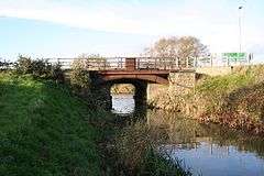 Tom Otter's Bridge |
|
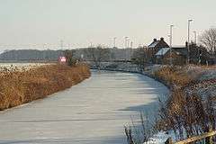 The Foss Dyke, frosted over |
|
 Drinsey Nook |
|
| OS grid reference | SK870743 |
|---|---|
| – London | 153 mi (246 km) S |
| District | West Lindsey |
| Shire county | Lincolnshire |
| Region | East Midlands |
| Country | England |
| Sovereign state | United Kingdom |
| Post town | Lincoln |
| Postcode district | LN1 |
| Police | Lincolnshire |
| Fire | Lincolnshire |
| Ambulance | East Midlands |
| EU Parliament | East Midlands |
| UK Parliament | Gainsborough |
|
|
Coordinates: 53°15′33″N 0°41′47″W / 53.259189°N 0.696325°W
Drinsey Nook is a small village in the West Lindsey district of Lincolnshire, England. It is situated approximately 2 miles (3 km) south-west from Saxilby, close to the county border with Nottinghamshire. The village sits on the bank of the east of Lincoln section of the Foss Dyke, a canal which runs from the River Trent to the River Witham. The population of the village is included in the civil parish of Kettlethorpe.
Drinsey Nook is notable for Tom Otter, a man who murdered his new wife in 1805. Otter, reputedly from Treswell, was already a married when he married his wife, Mary, whom he murdered the same day near the bridge that now bears his name. He was hanged in 1806, and was held in a Gibbet post adjacent to Gibbet Wood.[1][2] Tom Otter lane is the B1190 running south from the village, and Tom Otters Bridge is named after the site of the murder.[3][2]
References
- ↑ The handbook guide to lincoln and business intelligencer (3 ed.). R. E. Leary. 1855. p. 64. Retrieved 23 July 2011.
- 1 2 "Tom Otter - Fact or Fiction?". Saxilby and District History Group. 2013. Retrieved 2013-04-09.
- ↑ Pickering, W (1848). The Gentleman's Magazine (Vol 30 ed.). p. 296.
External links
 Media related to Drinsey Nook at Wikimedia Commons
- The Tale Of Tom Otter
England Portal | |
| Unitary authorities | |
| Boroughs or districts | |
| Major settlements |
|
| Topics | |