Dovedale
Coordinates: 53°03′35″N 1°46′36″W / 53.0597°N 1.7767°W
| Dovedale | |
| Valley | |
 Thorpe Cloud and Stepping Stones, Dovedale | |
| Country | England |
|---|---|
| Regions | Staffordshire, Derbyshire |
| River | River Dove |
| Geology | limestone |
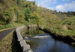
Dovedale is a valley in the Peak District of England.[1] The land is owned by the National Trust, and annually attracts a million visitors.[2] The valley was cut by the River Dove and runs for just over 3 miles (5 km) between Milldale in the north and a wooded ravine near Thorpe Cloud and Bunster Hill in the south.[3] In the wooded ravine, a set of stepping stones cross the river,[4] and there are two caves known as the Dove Holes.
Dovedale's other attractions include rock pillars such as Ilam Rock,[5] Viator's Bridge, and the limestone features Lovers' Leap and Reynard's Cave.[6]
History
The limestone rock that forms the geology of Dovedale is the fossilised remains of sea creatures that lived in a shallow sea over the area during the Carboniferous period, about 350 million years ago. During the two ice ages, the limestone was cut into craggy shapes known as reef limestone by the melting ice, and dry caves such as Dove Holes and Reynard's Kitchen Cave were formed.[7]
The caves were used as shelters by hunters around 13,000 BCE, and Dovedale has seen continuous human activity since. Around 4,500 years ago Neolithic farmers used the caves as tombs. There is evidence from Reynard's Cave of Bronze Age activity and artifacts found there are displayed at Buxton Museum and Art Gallery.[8]
Vikings settled in the area around 800 CE. Local place names such as Thorpe are of Scandinavian origin.[9] These settlements became permanent, and Thorpe is mentioned in the Domesday Book of 1086.[10]
Viator's Bridge, a packhorse bridge in Milldale has been in use since the medieval period when silks and flax were transported from nearby Wetton and Alstonefield.[11]
Tourism started in the 18th century, and Dovedale is now one of the most visited natural tourist sites in Britain.
In July 2014 it was announced that a hoard of Late Iron Age and Roman coins has been discovered in Reynard's Kitchen Cave.[12] The 26 coins discovered, which have been declared as "treasure", included three Roman coins that pre-date the Roman invasion of Britain, and 20 other gold and silver pieces of Late Iron Age date and thought to derive from the Corieltavi tribe. National Trust archaeologist Rachael Hall said: "The coins would suggest a serious amount of wealth and power of the individual who owned them."[13] The coins were scheduled to go on display at Buxton Museum in late 2014.
River Dove

The River Dove is a famous trout stream. Charles Cotton's Fishing House, the inspiration for Izaak Walton's The Compleat Angler,[14] stands in the woods by the river. From Hartington to its confluence with the River Manifold at Ilam the River Dove flows through the scenic limestone valley known as Dove Valley,[15] or Dovedale. From Hartington south to Ilam, a distance of eight miles (13 km), the Dove flows through Beresford Dale, Wolfscote Dale, Milldale, and then Dovedale.
National Trust
Much of the dale is in the ownership of the National Trust's South Peak Estate. Dovedale was acquired in 1934, with successive properties added until 1938, and Wolfscote Dale in 1948.
Dovedale became a National Nature Reserve in 2006 in recognition that it is "one of England's finest wildlife sites" with diverse plant life and interesting rock formations.[16] The National Trust became embroiled in controversy in 2010, when in conjunction with Derbyshire County Council it oversaw the renovation of Dovedale's iconic stepping stones. It involved topping all but one of the stones with layers of mortar and limestone slabs.
Thorpe Cloud
At the southern end of Dovedale, at grid reference SK151510 between the villages of Thorpe and Ilam, stands Thorpe Cloud, 942 ft (287 m), an isolated limestone hill known as a reef knoll. It provides a viewpoint north up the dale and south across the Midlands plain.[17] Its name "cloud" is a derivation of the Old English word clud which means "hill". On the opposite bank, at grid reference SK141516, is the higher but less isolated Bunster Hill, 1,079 ft (329 m), which is also a reef knoll. They were acquired by the National Trust in 1934 for the South Peak Estate.
Milldale
Milldale is a village of stone cottages at the northern end of Dovedale and the main access point to the dale from the north.[18] A corn mill existed until the mid-19th century, its stables are now used as an information hut by the National Trust.[19]
Viator's Bridge

The ancient, narrow packhorse bridge at Milldale originally had no side walls so that horses with panniers could cross the bridge without being impeded. Izaak Walton, who refers to himself as "Viator", which is Latin for "traveller", wrote about it in The Compleat Angler:[20]
"What’s here, the sign of a bridge? Do you travel in wheelbarrows in this country? This bridge was made for nothing else – why a mouse can hardly go over it, tis not two fingers broad!"
From this the bridge acquired the name Viator's Bridge.[21]
The bridge has been in use since the medieval period, for packhorses transporting silks and flax from nearby Wetton and Alstonefield. It is listed as an ancient monument.[22]
Limestone formations

Dovedale is notable for its numerous limestone formations. The most southerly named formation, Dovedale Castle, is a short distance along the river from the stepping stones at Thorpe Cloud. A set of steps accesses the limestone promontory called Lover's Leap. The steps were built by Italian prisoners of war captured in the Second World War and are now maintained by the National Trust and the National Park Authority
At Lover's Leap, a young woman who believed her lover had been killed in the Napoleonic Wars threw herself from the promontory. Her skirt caught in the branches of a tree as she fell and saved her life. When she got home, she heard her lover was alive. There are other similar legends about Lover's Leap, including one that places the same story in World War II.
Opposite Lover's Leap is a limestone formation called the Twelve Apostles. The rock spires have been created from hard reef limestone; they protrude from the valley side, and the river has eroded the rock and soil around them. The National Trust clears plant life to ensure the rock formations are visible.[6]
- Ravenstor
- Pickering Tor
- Tissington Spires
- Dovedale Church
- Reynard's Cave
- Lionshead Rock
- Ilam Rock
- Shepherd's Abbey
- Dove Holes
Natural history

Dovedale is of special ecological interest for its plant life, particularly the calcareous ash woods, which are considered among the best in England.[6] There are unusual plants such as Solomon's seal, lily of the valley, Paris quadrifolia and small and large-leaved lime trees. Birds found here include common kingfisher, grey heron and dipper.
Tourism
Gentry comprised most of the visitors to Dovedale during the 18th and 19th centuries. From 1899 the Ashbourne-Buxton railway line ran to Thorpe Cloud station, above the village of Thorpe, making Dovedale more widely accessible to walkers and hikers of all social classes. Improvements in road transport facilitated travel to the area as well.
In 1931 Ramsay MacDonald's Labour government recommended creating a ‘National Park Authority’ to select natural areas for designation as national parks. Dovedale was one of the areas selected, and it was eventually included within Peak District National Park when it became Britain's first National Park in 1951.
In July 1937, Staffordshire County Council converted the Leek and Manifold Valley Light Railway into a tarmac path now known as Manifold Way. The Ashbourne-Buxton railway line closed in the mid-1960s and was converted into a track known as Tissington Trail.
In a Peak District National Park survey conducted in 1986/87, more than a fifth of visitors said walking was their main reason for visiting. A footpath count on a Sunday in August 1990 recorded 4,421 walkers on the Staffordshire side of the river and 3,597 on the Derbyshire bank.Riverside paths make the valley accessible to walkers.[23]
Fishing has grown in popularity as well, due in part to associations with Izaak Walton's The Compleat Angler. Some fishing rights are held by the Izaak Walton Hotel (part of the Duke of Rutland's estate at the southern end of Dovedale on the Staffordshire bank, SK143508).
Increased popularity has given rise to problems of congestion and erosion.
Literary and cultural associations
Charles Cotton's Fishing House, the inspiration for Izaak Walton's The Compleat Angler, stands in the woods by the River Dove.
Samuel Johnson, Lord Tennyson, John Ruskin and Lord Byron all praised Dovedale's scenery.[24] The last wrote of Dovedale to the poet Thomas Moore, "I can assure you there are things in Derbyshire as noble as Greece or Switzerland."[25]
Elizabeth Bennet and Mr Darcy talk about her travels in Derbyshire, including Dove Dale, after they meet unexpectedly at Pemberley in Jane Austen's Pride and Prejudice.
Dovedale was featured on the 2005 BBC TV programme Seven Natural Wonders as one of the wonders of the Midlands. The area along the river was used in Franco Zeffirelli's 1996 version and the BBC's 2006 version of Jane Eyre,[26] and Dovedale also featured in the 2008 film The Other Boleyn Girl.[27] The Ridley Scott film Robin Hood also used Dovedale as a location, and it can be clearly seen in several scenes towards the end of the movie.
Dovedale Dash
The Dovedale Dash is an annual 4 3⁄4 miles (7.6 km) cross-country race along the banks of the River Dove, along Dovedale, and between the villages of Ilam and Thorpe.[28] First organised in 1953, the race takes place on the first Sunday of November, although previously it was held on the closest Sunday to Guy Fawkes Night. The race has been cancelled on four occasions, most recently in 1998, 2000 and 2004, as a result of bad weather.
References
| Wikimedia Commons has media related to Dovedale. |
Notes
- ↑ "Peak District walk down Dovedale from Alstonefield". www.cressbrook.co.uk. Retrieved 2008-04-04.
- ↑ "Dovedale - Dovedale in Derbyshire and the Peak District". www.derbyshireuk.net. Retrieved 2008-04-04.
- ↑ "Dovedale Derbyshire". www.ashbourne-town.com. Retrieved 2008-04-04.
- ↑ "Discover Derbyshire and the Peak District". www.derbyshire-peakdistrict.co.uk. Retrieved 2008-04-04.
- ↑ "Walks in The Peak District - Dove Dale and Wolfscote Dale walk". www.walkingenglishman.com. Retrieved 2008-04-04.
- 1 2 3 "Ilam Park – Dovedale". National Trust. Archived from the original on 2008-03-17. Retrieved 2008-04-04.
- ↑ "The Peak District National Park - Fact Zone 8. Dovedale and the Dove Valley". www.peakdistrict-education.gov.uk. Retrieved 2008-04-04.
- ↑ "Archaeology_caves". www.thepeakdistrict.info. Retrieved 2008-04-04.
- ↑ Anglo-Saxon and Viking Derbyshire, Richard Bunting, Wye Valley Press (April 1993), ISBN 0-946404-03-8
- ↑ "The Domesday Book Online - Derbyshire S-Z". www.domesdaybook.co.uk. Retrieved 2008-04-05.
- ↑ "Milldale near Alstonefield in the Peak District National Park". www.derbyshireuk.net. Retrieved 2008-04-05.
- ↑ "Visit to site of ancient coin discovery in Derbyshire". BBC News. 7 July 2014. Retrieved 15 June 2016.
- ↑ "Dovedale Roman and Iron Age coins found after 2,000 years". BBC News. 7 July 2014. Retrieved 15 June 2016.
- ↑ "The Philosopher, Fish and the Dove". BBC Radio 4. Retrieved 15 June 2016.
- ↑ "Dovedale and the Dove Valley". peakdistrict-education.gov.uk. Archived from the original on 8 March 2010. Retrieved 15 June 2016.
- ↑ "Natural England celebrates new National Nature Reserve". Natural England. Retrieved 15 June 2016.
- ↑ "Dovedale and Thorpe Cloud". www.cressbrook.co.uk. Retrieved 2008-04-04.
- ↑ "Milldale – Peak District Towns and Villages". www.cressbrook.co.uk. Retrieved 2008-04-06.
- ↑ "Milldale near Alstonefield in the Peak District National Park". www.derbyshireuk.net. Retrieved 2008-04-04.
- ↑ "Discover Derbyshire and the Peak District". www.derbyshire-peakdistrict.co.uk. Retrieved 2008-04-04.
- ↑ "Viators Bridge - Milldale". www.peakdistrictonline.co.uk. Retrieved 2008-04-04.
- ↑ "Local Plan - Peak District National Park Authority". www.peakdistrict.org. Retrieved 2008-04-04.
- ↑ "Discover Derbyshire and the Peak District". www.derbyshire-peakdistrict.co.uk. Retrieved 2008-04-05.
- ↑ "Dovedale - High Peak". Retrieved 22 March 2016.
- ↑ "The Works of Lord Byron: In Verse and Prose. Including His Letters, Journals, Etc. With a Sketch of His Life". A.V. Blake. 1844. p. 110. Retrieved 28 November 2016.
- ↑ "Jane Eyre". Retrieved 22 March 2016.
- ↑ "Visit Peak District Film Locations". visitpeakdistrict.com. Retrieved 19 September 2013.
- ↑ "Dovedale Dash 2006". www.dovedaledash.co.uk. Retrieved 2008-04-04.
Bibliography
- Anglo-Saxon and Viking Derbyshire, Richard Bunting, Wye Valley Press (April 1993), ISBN 0-946404-03-8
- Dovedale Guide, Keith H. Mantell, Derbyshire Countryside Ltd; (February 1991), ISBN 0-85100-095-9
- Dovedale and the Manifold Valley, Brian Spencer and Lindsey Porter, Moorland Publishing (May 1975), ISBN 0-903485-14-1

