Ladybower Reservoir
| Ladybower Reservoir | |
|---|---|
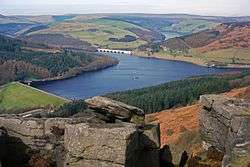 Ladybower Reservoir from Bamford Edge (seen in the foreground); the wall can be seen in the bottom left and the Ashopton Viaduct in the top centre | |
| Location | Upper Derwent Valley, Derbyshire |
| Coordinates | 53°23′N 1°43′W / 53.383°N 1.717°WCoordinates: 53°23′N 1°43′W / 53.383°N 1.717°W |
| Lake type | reservoir |
| Primary inflows | River Ashop, River Derwent |
| Primary outflows | River Derwent |
| Catchment area | 6,364 acres (2,575 ha) |
| Basin countries | United Kingdom |
| Max. length | 2.5 mi (4.0 km) |
| Max. width | 1,950 ft (590 m) |
| Surface area | 210 ha (520 acres)[1] |
| Average depth | 95 ft (29 m) |
| Max. depth | 135 ft (41 m) |
| Water volume | 27,800,000 m3 (6.1×10⁹ imp gal)[1] |
| Shore length1 | 13 mi (21 km) |
| Surface elevation | 668 ft (204 m) |
| References | [2] |
| 1 Shore length is not a well-defined measure. | |
Ladybower Reservoir is a large Y-shaped reservoir, the lowest of three in the Upper Derwent Valley in Derbyshire, England. The River Ashop flows into the reservoir from the west; the River Derwent flows south, initially through Howden Reservoir, then Derwent Reservoir, and finally through Ladybower Reservoir.
The area is now a tourist attraction, with the Fairholmes visitors' centre located at the northern tip of Ladybower.
Design and construction

Ladybower was built between 1935 and 1943 by the Derwent Valley Water Board to supplement the other two reservoirs in supplying the water needs of the East Midlands. It took a further two years to fill (1945). The dam differs from the Howden Reservoir and Derwent Reservoir in that it is a clay-cored earth embankment, and not a solid masonry dam. Below the dam is a cut-off trench 180 feet (55 m) deep and 6 feet (1.8 m) wide filled with concrete, stretching 500 feet (150 m) into the hills each side, to stop water leaking round the dam. The dam wall was built by Richard Baillie and Sons, a Scottish company. The two viaducts, Ashopton and Ladybower, needed to carry the trunk roads over the reservoir were built by the London firm of Holloways, using a steel frame clad in concrete. The project was delayed when the Second World War broke out in 1939, making labour and raw materials scarce. But construction was continued due to the strategic importance of maintaining supplies. King George VI, accompanied by Queen Elizabeth, formally opened the reservoir on 25 September 1945.
During the 1990s the wall was raised and strengthened to reduce the risk of over-topping in a major flood. The original dam wall contains 100,000 tons of concrete, over one million tons of earth and 100,000 tons of clay for the core. The upstream face is stone faced. Materials were brought to the site on the Derwent Valley Water Board's own branch line and their sidings off the main line in the Hope Valley.
The dam's design is unusual in having two totally enclosed bellmouth overflows[3] (locally named the "plugholes") at the side of the wall. These are stone and of 80 feet (24 m) diameter with outlets of 15 feet (4.6 m) diameter. Each discharges via its own valve house at the base of the dam. The overflows originally had walkways around them but they were dismantled many years ago. The bell mouths are often completely out of the water and are only rarely submerged, often after heavy rainfall or flooding.
Water usage

The water is used for river control and to compensate for the water retained by all three dams, along with supply into the drinking water system and hydroelectricity generation.[4] Drinking water must be pumped to treatment works rather than using gravity flow as in the other two reservoirs, increasing costs.[5] The drinking water is treated at Bamford water treatment works by Severn Trent Water. Treated water flows south down the 28 miles (45 km) long Derwent Valley Aqueduct to a covered service reservoir at Ambergate to supply clean water to the cities of Derby and Leicester in the East Midlands of England. The aqueduct passes through the park of Chatsworth House. The path of the aqueduct is marked by a series of valve houses built of stone and domed steel access chambers. A tunnel carries some of the water from the Derwent Valley eastwards through the hill and into the lower of the two Rivelin Dams to supply Sheffield.
Ashopton Village

The building of the reservoir resulted in the 'drowning' of the villages of Ashopton and Derwent (including Derwent Woodlands church and Derwent Hall). Ashopton stood roughly where the road to the Snake Pass met the Snake valley. The buildings in Ashopton were demolished before the reservoir was filled, but much of the structure of Derwent village was still visible during a dry summer some 14 years later. The narrow stone Packhorse Bridge over the Derwent was removed and rebuilt at the head of the Howden reservoir. The clock tower of the church had been left standing and the upper part of it was visible above the water level until 1947, when it was seen as a hazard and demolished with explosives on 15 December.[6]
Gallery
 The reservoir
 Overflow for the Ladybower Reservoir in full flow, May 2006
 Overflow for the Ladybower Reservoir
 View from the Ladybower Wall across the water
 Ladybower Overflow valve-houses
 Layout of the Ladybower Reservoir
References
- 1 2 Harwood, Stephen (September 2000). "Severn Trent Water, The Ladybower Reservoir Dam Refurbishment Scheme" (PDF). Archived from the original (PDF) on 2011-10-04. Retrieved 2013-04-24.
- ↑ Walls across the Valley, Page 254 Table 2
- ↑ Bellmouth in action
- ↑ Dent, Martin. "Severn Trent Water's Hydro Expansion" (PDF). Retrieved 2013-04-24.
- ↑ The Upper Catchment
- ↑ The Story of the lost villages of Derwent and Ashopton: Harry Gill 1947
Further reading
- Robinson, Brian (1993). Walls across the Valley: The building of the Howden and Derwent Dams. Cromford: Scarthin. ISBN 978-0-907758-57-0.
External links
| Wikimedia Commons has media related to Ladybower Reservoir. |
