Tissington Trail
| Access points on the route |
|---|
|
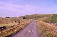
Parsley Hay (where it joins High Peak Trail) |
Feb2006.jpg)


The Tissington Trail is a bridleway and walk/cycle path in Derbyshire, England. Opened in 1971, and now a part of the National Cycle Network, it runs for 13 miles (21 km) from Parsley Hay (53°10′14″N 1°46′58″W / 53.1706°N 1.7828°W) in the north to Ashbourne (53°01′11″N 1°44′23″W / 53.0196°N 1.7397°W) in the south, along part of the trackbed of the former railway line connecting Ashbourne to Buxton. It takes its name from the village of Tissington, which it skirts.
At Parsley Hay, a small settlement to the north-east of Hartington, it is joined by the High Peak Trail, a walk/cycle trail which runs 17 miles (27 km) in total from High Peak Junction near Cromford, Matlock, to Dowlow, near Buxton.
The trail has a firm crushed limestone surface which makes it ideal for cyclists and walkers of all ability, including wheelchair users, assisted by easy level access onto the trail at many points along its route. The elevated nature of the line (at Parsley Hay it is over 1,000 feet (305 m) in height) affords good views, but the trail can also be exposed in poor weather. Although not greatly noticeable, the trail runs gently downhill from Parsley Hay southwards. Note however that about 1⁄4-mile (400 m) north of the cycle hire centre at Mapleton Lane, Ashbourne, the trail dips down and up where a viaduct has been removed; both slopes are about 40 m (130 ft) long with gradients of 1:9.
Hartington signal box, beside the trail, though some distance from the village, has been converted into an Information Centre, open in summer on Saturdays, Sundays and Bank Holidays. The Park Authority operates cycle hire at both ends of the Trail, i.e. at Parsley Hay and Ashbourne.
From Hartington station northwards, the route is also part of the Pennine Bridleway, a 130-mile (209 km) leisure route which includes 73 miles (117 km) through Derbyshire to the South Pennines. The Bridleway has two southern starting points, the other being at Middleton Top, near Cromford, on the High Peak Trail.
Facilities
- At Parsley Hay (map ref: SK146637) there is a car park, toilets, picnic site, visitor information, cafe and cycle hire. There is direct level access to the trail.
- At Hartington Station (map ref: SK149610) there is a car park with toilets and picnic site. There is level access onto the trail.
- At Ruby Wood (map ref: SK149604) there is a car park and a picnic site.
- At Alsop-en-le-Dale Station (map Ref: SK155549) there is a car park with picnic site. There is level access onto the trail.
- At Tissington Station (map ref: SK177520) there is a car park, with toilets and picnic site, with a tea room in the village itself.
- At Thorpe Station (map ref: SK165503) there is a small car park and picnic site, with level access onto the trail.
- At Narlows Lane, near Thorpe (map ref: SK163504) there is a car park.
- At Mapleton Lane, near Ashbourne (map ref: SK175473) there is a car park, toilets, and cycle hire.
History of the route
Built by the LNWR, the line opened in 1899, and linked with the Cromford and High Peak Railway at Parsley Hay, a line completed nearly 70 years earlier to link the Cromford Canal wharf at High Peak Junction with the Peak Forest Canal at Whaley Bridge. It was the last of the railways to be built in the Peak District. Whilst the section from Parsley Hay to Ashbourne was single track (from Parsley Hay north to Buxton it was double) the formation was constructed to allow for doubling if necessary, but this never happened. There were passing loops at Hartington, Alsop-en-le-Dale, Tissington and Thorpe Cloud.
Despite the relatively short length of this branch line, it was deservedly popular with walkers and ramblers, enjoying its heyday in the 1930s. Apart from the elevated views over the Peak itself, a large attraction was that this line passed close to Dovedale. The line for a time also carried a through-service (i.e. without changing carriages) for passengers from London Euston, (via Nuneaton, Uttoxeter and Ashbourne), to Buxton and Manchester. A daily train also transported local milk to London. However, the line suffered from passing through a sparsely populated area, and it was closed to regular passenger traffic in 1954, and all services between Ashbourne and Hartington, including excursion traffic and specials (such as run during bad weather, or Well dressing specials), ceased in October 1963. The route between Hartington and Parsley Hay survived until October 1967.
See also
References
Blakemore, M. & Mosley D., "Railways of the Peak District", Atlantic Publishers, 2003, ISBN 1-902827-09-0
External links
| Wikimedia Commons has media related to Tissington trail. |
Coordinates: 53°05′46″N 1°46′32″W / 53.096°N 1.7755°W