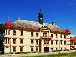
Dolní Rožínka
| Dolní Rožínka | |||
|---|---|---|---|
| Municipality | |||
 | |||
| |||
 Dolní Rožínka | |||
| Coordinates: 49°28′37″N 16°12′29″E / 49.47694°N 16.20806°ECoordinates: 49°28′37″N 16°12′29″E / 49.47694°N 16.20806°E | |||
| Country |
| ||
| Region | Vysočina | ||
| District | Žďár nad Sázavou | ||
| Area | |||
| • Total | 4.46 km2 (1.72 sq mi) | ||
| Elevation | 502 m (1,647 ft) | ||
| Population (1.1.2014) | |||
| • Total | 630 | ||
| • Density | 140/km2 (370/sq mi) | ||
| Postal code | 592 51 | ||
| Website | http://www.dolni-rozinka.cz | ||

Dolní Rožínka is a village and municipality (obec) in Žďár nad Sázavou District in the Vysočina Region of the Czech Republic.
The municipality covers an area of 4.46 square kilometres (1.72 sq mi), and has a population of 630 (as at 1. 1. 2014).
Dolní Rožínka lies approximately 22 kilometres (14 mi) south-east of Žďár nad Sázavou, 46 km (29 mi) east of Jihlava, and 146 km (91 mi) south-east of Prague.
The village hosts the only currently-operational uranium mine and processing mill in the Czech Republic.
References
| Wikimedia Commons has media related to Dolní Rožínka. |
This article is issued from Wikipedia - version of the 4/7/2016. The text is available under the Creative Commons Attribution/Share Alike but additional terms may apply for the media files.