Dégelis
| Dégelis | |
|---|---|
| City | |
 | |
 Location within Témiscouata RCM | |
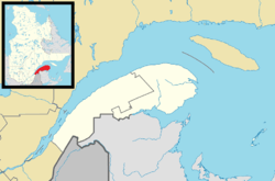 Dégelis Location in eastern Quebec | |
| Coordinates: 47°33′N 68°39′W / 47.55°N 68.65°WCoordinates: 47°33′N 68°39′W / 47.55°N 68.65°W[1] | |
| Country |
|
| Province |
|
| Region | Bas-Saint-Laurent |
| RCM | Témiscouata |
| Settled | 1880 |
| Constituted | December 13, 1969 |
| Government[2] | |
| • Mayor | Claude Lavoie |
| • Federal riding |
Rimouski-Neigette— Témiscouata—Les Basques |
| • Prov. riding | Rivière-du-Loup-Témiscouata |
| Area[2][3] | |
| • Total | 568.00 km2 (219.31 sq mi) |
| • Land | 556.64 km2 (214.92 sq mi) |
| Population (2011)[3] | |
| • Total | 3,051 |
| • Density | 5.5/km2 (14/sq mi) |
| • Pop 2006-2011 |
|
| • Dwellings | 1,517 |
| Time zone | EST (UTC−5) |
| • Summer (DST) | EDT (UTC−4) |
| Postal code(s) | G5T 2G3 |
| Area code(s) | 418 and 581 |
| Highways |
|
| Website |
www |
Dégelis is a city in Témiscouata Regional County Municipality within the Bas-Saint-Laurent region of Quebec. Its population in the Canada 2011 Census was 3,051.[2][3] The Madawaska River flows from Lake Témiscouata, through Degelis, to join the Saint John River at 32 kilometres (20 mi) to the East at Edmundston, New Brunswick.
Toponymy
Located on the banks of the Madawaska River (Saint John River), the city owes its name to a physical phenomenon: a zone of the river located in front the village, that never freezes.[4] A Dégelis, in Old French, means a zone on the water free of ice[5] (which is the phenomenon observed in Dégelis), a local winter thaw (no apparent reason),[6] meaning an opening in the ice during the seasonal thawing.
The area corresponding to Dégelis is named Dégelé (English: thawed) in a report by Joseph Bouchette in 1815. The spelling at the time varies considerably. Clerical and administrative documents dating from 1858 to 1878 refer to the parish under the name Dégely,[7] Ste. Rose Dégely,[8] or (Sainte-Rose-du) Dégeli.[9] Names "Sainte-Rose-du-Dégel" and "Dègelis" were also used for a period.[4]
The mission Catholic founded in 1860 took the name of "Sainte-Rose-du-Dégelé.[4] The choice of Sainte-Rose as a protective was conducted by Langevin, bishop of Rimouski from 1867 to 1891 in honor of Rose Marquis, benefactress of the mission.[10] The parish canonically was erected in 1885 and the municipality of parish was officially created the same year kept the same name.[4] This does not prevent Le Naturaliste Canadien (English: The Canadian Naturalist), a scientific publication, refer to them as the Sainte-Rose-du-Dégelis in 1882. The post office of the place was called Sainte-Rose-du-Dégelé since 1879 and kept it until 1968.[4] In fact, 1967, the name of the municipality was changed to Sainte-Rose-du-Dégelis for lexical considerations.[4] In 1969, the name was shortened to Dégelis when the place received town status.[4]
The gentiles are appointed Dégelisiens and Dégelisiennes.[11]
Geography
The town is situated on Autoroute 85, also known as the Trans-Canada Highway, close to the Quebec-New Brunswick Border.
Dégelis is located on the south slope of St. Lawrence River in 290 kilometres (180 mi) southeast of Quebec and 500 kilometres (310 mi) southwest of Gaspé near the border with New Brunswick. Most important cities near Dégelis are Rivière-du-Loup in 85 kilometres (53 mi) northeast La Pocatière, Quebec in 150 kilometres (93 mi) to west and Edmundston in New Brunswick to 35 kilometres (22 mi) southeast. Dégelis territory covers an area of 562.84 kilometres (349.73 mi).[11]
City Dégelis is in the Témiscouata Regional County Municipality in administrative region of the Bas-Saint-Laurent. Parish Dégelis is part of the Archdiocese of Rimouski.
History
Dégelis was founded in 1885 and its initial name was Sainte-Rose du Dégelé. Before its foundation, it was a military fort used to defend Canada's border with United States. Four families of British soldiers lived in two locations in the territory of the current city from 1814 to 1823 . In 1839, the construction of the fort began on the current city of Dégelis. The small fort was part of a series of forts which included Fort Ingall. Soldiers and settlers inhabited the fort and its surrounding area. Some settlers remained in the region after the Aroostook War.
The catholic mission Sainte-Rose-du-Dégelé was founded in 1860. The foundation's mission coincides with the beginning of colonization of the territory then known as Le Dégely.
Demographics
Population
| Canada census – Dégelis community profile | |||
|---|---|---|---|
| 2011 | 2006 | 2001 | |
| Population: | 3,051 (-4.9% from 2006) | 3,209 (-3.3% from 2001) | 3,317 (-3.5% from 1996) |
| Land area: | 556.64 km2 (214.92 sq mi) | 556.64 km2 (214.92 sq mi) | 556.63 km2 (214.92 sq mi) |
| Population density: | 5.5/km2 (14/sq mi) | 5.8/km2 (15/sq mi) | 6.0/km2 (16/sq mi) |
| Median age: | 49.6 (M: 49.0, F: 50.1) | 45.6 (M: 45.1, F: 46.0) | 40.7 (M: 39.9, F: 41.5) |
| Total private dwellings: | 1,517 | 1,630 | 1,436 |
| Median household income: | $39,682 | $40,360 | $33,690 |
| References: 2011[12] 2006[13] 2001[14] | |||
| Historical Census Data - Dégelis, Quebec[15] | ||
|---|---|---|
| Year | Pop. | ±% |
| 1991 | 3,350 | — |
| 1996 | 3,437 | +2.6% |
| 2001 | 3,317 | −3.5% |
| 2006 | 3,209 | −3.3% |
| 2011 | 3,051 | −4.9% |
Language
The mother tongue of most residents is, and has always been, French.
| Canada Census Mother Tongue - Dégelis, Quebec[15] | ||||||||||||||||||
|---|---|---|---|---|---|---|---|---|---|---|---|---|---|---|---|---|---|---|
| Census | Total | French |
English |
French & English |
Other | |||||||||||||
| Year | Responses | Count | Trend | Pop % | Count | Trend | Pop % | Count | Trend | Pop % | Count | Trend | Pop % | |||||
| 2011 |
2,975 |
2,950 | |
99.16% | 15 | |
0.50% | 5 | |
0.17% | 5 | |
0.17% | |||||
| 2006 |
3,100 |
3,060 | |
98.71% | 20 | |
0.65% | 10 | |
0.32% | 10 | |
0.32% | |||||
| 2001 |
3,235 |
3,195 | |
98.76% | 0 | |
0.00% | 30 | |
0.93% | 10 | |
0.31% | |||||
| 1996 |
3,350 |
3,330 | n/a | 99.40% | 10 | n/a | 0.30% | 10 | n/a | 0.30% | 0 | n/a | 0.00% | |||||
Economy
The economy of Dégelis revolves mainly around the forest industry. The city is home to a sawmill which produces hardwood briquettes of maple, oak, beech, and ash. The municipality has reduced hours of operation.
See also
References
- ↑ Reference number 17393 of the Commission de toponymie du Québec (French)
- 1 2 3 Geographic code 13005 in the official Répertoire des municipalités (French)
- 1 2 3 "(Code 2413005) Census Profile". 2011 census. Statistics Canada. 2012.
- 1 2 3 4 5 6 7 Commission de toponymie du Québec (Quebec Geographical Names Board) - Banque de noms de lieux (Bank of places names) - Toponym: "Dégelis"; page accessed on September 17, 2010
- ↑ Pascal Poirier, Le parler franco-acadien et ses origins (English: The Franco-Acadian talk and its origins), 1928
- ↑ Aubert de la Rue, Le français parlé aux îles St-Pierre et Miquelon (In English: French spoken to St. Pierre and Miquelon), 1944
- ↑ Rapport sur les missions du diocèse de Québec (English: Missions Report of the Diocese of Québec), No. 18, 1868
- ↑ Statement of the public accounts of the province of Quebec and annual report of the auditor of the province, 1878
- ↑ Report on the missions of the diocese of Quebec, number 13, 1859
- ↑ Les noms géographiques de la province de Québec (English: Geographical names of the province of Quebec)
- 1 2 Government of Quebec. "Directory municipalities - Dégelis". Ministère des Affaires municipals (English: Ministry of municipal Affairs), Régions et Occupation du territoire (English: Regions and land occupancy). Retrieved January 31, 2011.
- ↑ "2011 Community Profiles". Canada 2011 Census. Statistics Canada. July 5, 2013. Retrieved 2014-02-20.
- ↑ "2006 Community Profiles". Canada 2006 Census. Statistics Canada. March 30, 2011. Retrieved 2014-02-20.
- ↑ "2001 Community Profiles". Canada 2001 Census. Statistics Canada. February 17, 2012. Retrieved 2014-02-20.
- 1 2 Statistics Canada: 1996, 2001, 2006, 2011 census
External links
| Wikimedia Commons has media related to Dégelis. |
- (French) Official municipality site
 |
Saint-Juste-du-Lac | Auclair / Lejeune | |
|
| Témiscouata-sur-le-Lac / Packington |
|
| ||
| ||||
| | ||||
| Saint-Jean-de-la-Lande | |
| Cities & Towns | |
|---|---|
| Municipalities | |
| Parishes | |
| |